Tzompantepec

Last updated
Tzompantepec
DivinoSalvadorTzompantepec12.JPG
Divino Salvador Church
Coordinates: 19°22′30″N98°5′26″W / 19.37500°N 98.09056°W / 19.37500; -98.09056
CountryFlag of Mexico.svg  Mexico
State Tlaxcala
Municipality founded1822
Government
  Municipal presidentLorena Vazquez Zarate
Area
  Total38.357 km2 (14.810 sq mi)
Elevation
2,460 m (8,070 ft)
Population
 (2010)
  Total14,611 (municipality) 1,869 (seat) [1]
Time zone UTC-6 (Central Standard Time)
  Summer (DST) UTC-5 (Central Daylight Time)
Website Official website

Tzompantepec is a town and municipality located in the eastern portion of the Mexican state of Tlaxcala. It is located in the Central Mexican Plateau, almost entirely on the slopes of the La Malinche Volcano. The area was the earliest to be inhabited in Tlaxcala and it was also the site of the defeat of the Tlaxcallans in the early part of the Spanish Conquest. The municipality is mostly farmland but urban sprawl has limited both natural vegetation and wildlife.

Contents

The town

The town of Tzompantepec is located in eastern Tlaxcala state, 5.5km southwest of Xaloztoc, 9km southeast of Apizaco, and 25km east of the city of Tlaxcala on Highway 119. [2] [3] Although it is the seat of municipality of the same name, it has only about one fifth of the population of the largest community, San Andrés Ahuashuatepec. [1]

The parish church of the town is Divino Salvador (Divine Savior), which was built in the 17th century on a hill overlooking the town. Its facade is heavily decorated with estipite pilasters, gilded images of Saints Anne and Joachim and the Apostles John, Peter and James. The prophets Moses and Elijah appear in the capitals of the columns. [4] [2] The interior was redone in the early 20th century in 19th century style, conserved one painting by Antonio Caro done in 1681 and another by an anonymous painter from the same epoch depicting Jesus as a child accompanied by his parents and grandparents. [4] [3] The atrium in front of the church is still used for burials and is surrounded by a wall with inverted arches, with a clock at the entrance. [4] [3] This church is the focus of the main religious event, the feast of the Divine Savior, celebrated on August 6 and 7th. This event begins at 5 am with the singing of Las Mañanitas accompanied by mariachi, followed by a procession of the image of Jesus. [5] [3] Carnival is also celebrated here, with traditional dance such as the Huehues, danced to various types of music, including current pop songs. These dancers generally wear colorful costumes with religious symbolism as well as wooden masks. [3]

The San Andrés Church is on the main square of the town. Its facade is a mix of brick and glazed tile, a style called Palafox. [4] [2] Its walls are about a meter thick with stone, with the same material used to create the vault that covers the structure. The left side tower has two levels, arches, merlons and a small cupola. The right side tower has one level with arches. The atrium serves as a cemetery. Inside the baptistery is noted for its polychromatic stucco work. [3] [4]

The San Juan Temple dates to the 18th century. [2] [4] It has a simple facade and stone walls up to nearly a meter thick. It is also covered by a vault. The main entrance has an arch and choir window. Above this is a niche with an image of John the Baptist and a cross made of stucco. It has only one tower, with three levels which has arches and merlons. [3] [4]

The municipality

As seat, the town of Tzompantepec serves as the local government for seventeen locations, thirteen of which are populated communities. The largest of these are San Andrés Ahuashuatepec (pop. 10,114), San Juan Quetzalcoapan (pop. 1,262) and Xaltianquisco (pop. 884). The other locations are San Mateo Inophil (pop. 256), Rancho Buena Vista, Rancho Amoltepec, Otongatepec, La Providencia las Huertas, Rancho Cruztitla, El Llano, Mazapa, Fernando Armenta Ramos, Cuayecatl, Lucas Flores, Fraccionamiento del Divino Salvador, San José el Potrero, Imelda Flores Sanchez. [1] [3]

Together, these communities comprise a territory of 38.357km2 and borders the municipalities of Apizaco, Xaloztoc, Cuaxomulco, San José Teacalco, Tocatlán, Huamantla and Santa Cruz Tlaxcala. [6]

The municipal government consists of a municipal president, a syndic and seven representatives called regidors. [3]

Socioeconomics

In the municipality, 57.3% live in poverty, with 8.6% in extreme poverty. Ten percent live in substandard housing and 25% suffer food shortages. [7] However, overall socioeconomic marginalization is considered low because of the availability of social services such as medical attention and schools. [1] [7]

The main economic activities of the municipality are agriculture, livestock and manufacturing. The main handcraft of the municipality is ceramics, especially burnished and red clay pottery. One noted piece is the comal, used for the making of tortillas. The municipality is part of the “Textiles and Center” tourist route, which also promotes the Tzompantzingo Mountain, site of a major confrontation between Tlaxcallan and Spanish forces early in the Conquest. [3]

The average schooling of residents is 9.3 years, above the state average of 8.8. The municipality provides 16 preschools, 11 primary schools, eight middle schools and four high schools. [7]

Traditional dishes are based on local agricultural production and include those made with maguey larvae along with soups made with mushrooms, tortillas, corn, squash flowers, peas, cactus and fava beans, quesadillas with squash flowers and huitlacoche, barbacoa and mixote. [3]

History

The name is derived from Nahuatl and means “hill where the skulls of the sacrifice are stored.” [8] [3]

Tzompantepec is the site of the earliest human settlements in Tlaxcala. The area was first inhabited about 12,000 years ago with agriculture appearing about 8,300 years ago, leading to settlements. Around 1700 or 1600 BCE, various villages in this area into Puebla called the Tzompantepec culture, named after the site in the municipality, which contains the most typical and most complete remains of this culture. In the late phase of this culture, terrace farming appeared as well as houses on raised foundations and irrigation. The ceramics of this culture indicate influence the Tehuacan Valley in Puebla and from the Gulf Coast. [9]

The area remained occupied but not organized into a dominion until the 12th century, when consolidation of the three cultural groups of the state began. This area was part of the Teo Chichimecas, whose influence extended to Lake Texcoco by the 14th century. Another important group for this area are the Otomis, who migrated into Tlaxcala during these centuries. The 14th and 15th centuries were prosperous for the area and the population grew with contacts as far as the Yucatán and Central America, mostly through trade. [9] [3]

In the latter 15th century, the Aztec Empire threatened that of Tlaxcala. It could not conquer the area but blockaded it from its commercial ties, causing hardship. Tzompantepec and the rest of the dominion suffered shortages of goods as well as losses of men to Aztec flower wars, aimed to capture sacrifices for the gods. At the time of the Spanish arrival, the town was an important one in the Tlaxcallan dominion. [9]

In 1519, Hernán Cortés and the Spanish arrived with Totonac allies. In Tzompantepec on September 2 of that year, there was a major battle with the Tlaxcallans. The superior arms of the Spanish gave them victory against the Tlaxcallan force headed by Xicohtencatl. The battle made the Tlaxcallans allies with the Spanish against the Aztecs. [9]

Shortly after the Conquest, Cortés established a battalion here and the Divino Salvador Church was founded by the Franciscans. By the mid 16th century, this church became subordinate to Huamantla and the San Andrés Church was founded. [3] [10]

During the colonial period, the town of Tzompantepec governed an area that included what are now Cuaxomulco, San Francisco Tetlanohcan, San José Teacalco and Huamantla, but by the 19th century, it had become part of the Huamantla district. [10] [3]

In the late Mexican War of Independence, insurgents under Nicolás Bravo were in the area, and the municipality was established in 1822. [3] [11] During the Reform War, Tzompantepec was allied with the Liberals. [12]

The railroad connecting Mexico City with Veracruz reached the municipality in 1873. [12] A station was built in Tzompantepec, which allowed the area to export its grain production to both Mexico City and the Gulf coast. This mostly benefitted large haciendas such as Xaltelulco and Jonecuila. This put pressure on lands still in indigenous hands and for this reason many in the municipality supported the Mexican Revolution. However, only small, guerrilla-style clashes occurred here during the conflict. [3]

Geography

The municipality is located in the Central Mexican Plateau with an average altitude of 2,460 meters above sea level. Almost all of the territory is on the slopes of the La Malinche volcano. About twenty percent of the territory is rugged mountain, mostly in the south and west. Seventy percent is semi flat, mostly in the center and ten percent is flat, concentrated in the northwest. [6] [3] Most of the territory has been modified by humans. 4,812 hectares is dedicated to agricultural production, 85% of which is dedicated to crops and the rest to pasture.

Hydrography

The Apizaco River runs through a small portion for about four km. The smaller Amomolc extends through 4.5 meters, along with a number of seasonal streams. Other water sources include wells. [3]

Climate

The climate is temperate and semi moist. Average annual rainfall is 817.6mm, with most rain falling between April and September. The warmest months are April and May. Prevailing winds are from the northeast and average annual temperatures vary from a low of 4.7C to a high of 22.6C. [6] [3]

Flora and fauna

At the higher elevations there are various types of oak (Quercus laeta, Q. obtusata, Q. crassipes) as well as pines (Pinus leiophylla and Pino pseudostrobus). In the area of the Apizaco River there are trees such as Alnus acuminate, Taxodium mucrunatum, Salix bonplandiana and Fraxinus uhdei. The rest of the territory is farmland or urban areas with secondary vegetation. [3] [6]

Because of urban sprawl, wildlife is limited to smaller species such as rabbits, hares, moles, opossums, reptiles and birds. [3] [6]

Reforestation efforts have includes the planting of over 4,000 trees mostly by school and ecological organizations. [6]

Related Research Articles

<span class="mw-page-title-main">Tlaxcala (city)</span> Municipality in Tlaxcala, Mexico

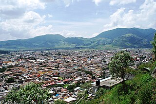
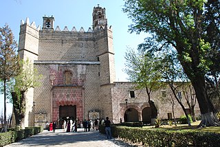
Tlaxcala, officially Tlaxcala de Xicohténcatl, is the capital city of the Mexican state of Tlaxcala and seat of the municipality of the same name. The city did not exist during the pre-Hispanic period but was laid out by the Spanish as a center of evangelization and governance after the Spanish conquest of the Aztec Empire. The city was designated as a diocese but eventually lost that status to Puebla as its population declined. The city still has many of its old colonial structures, including the former Franciscan monastery, and newer civic structures like the Xicohtencatl Theatre.

<span class="mw-page-title-main">Malinalco</span> Town & Municipality in State of Mexico, Mexico

Malinalco is the municipality inside of Ixtapan Region, is a town and municipality located 65 kilometers south of the city of Toluca in the south of the western portion of the State of Mexico. Malinalco is 115 km (71 mi) southwest of Mexico City.

<span class="mw-page-title-main">Azcapotzalco</span> Borough in Mexico City, Mexico

Azcapotzalco is a borough in Mexico City. Azcapotzalco is in the northwestern part of Mexico City.

<span class="mw-page-title-main">Tlaxcala</span> State of Mexico

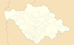
Tlaxcala, officially the Free and Sovereign State of Tlaxcala, is one of the 32 states which comprise the Federal Entities of Mexico. It is divided into 60 municipalities and the capital city is Tlaxcala City.

<span class="mw-page-title-main">Municipalities of Tlaxcala</span>

Tlaxcala is a state in Central Mexico that is divided into 60 municipalities. According to the 2020 Mexican Census, it is the fifth least populated state with 1,342,977 inhabitants and the 2nd smallest by land area spanning 3,996.6 square kilometres (1,543.1 sq mi).
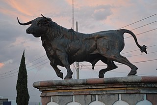
<span class="mw-page-title-main">Huamantla</span> Municipal seat in Tlaxcala, Mexico

Huamantla is a small city in Huamantla Municipality located in the eastern half of the Mexican state of Tlaxcala. The area has a long indigenous history, but the city itself was not founded until the early colonial period, in the 1530s. It is mostly agricultural but it is best known for its annual homage to an image of the Virgin Mary called Our Lady of Charity. This includes a month of festivities, the best known of which are the “night no one sleeps” when residents create six km of “carpets” on the streets made from colored sawdust, flowers and other materials. The other is the “Huamantlada” a running of the bulls similar to that in Pamplona.

<span class="mw-page-title-main">Malinche (volcano)</span> Volcano located in the states of Tlaxcala and Puebla in Mexico

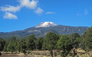
La Malinche, also known as Matlalcueye or Malintzin, is an inactive volcano located in the states of Tlaxcala and Puebla in Mexico. Officially, its summit reaches 4,461 metres (14,636 ft) above sea level, though it is generally considered to be closer to 4,440 metres (14,567 ft), using GPS measurements. It is the highest peak in Tlaxcala, the fifth-highest in Puebla, the sixth-highest in Mexico, the 23rd-highest in North America, and the 252nd-highest in the world. Its height above nearby cities varies from 1,908 metres (6,260 ft) above Huamantla, 2,461 metres (8,074 ft) above Villa Vicente Guerrero, 2,221 metres (7,287 ft) above Tlaxcala, to 2,299 metres (7,543 ft) above Puebla. The summit is 22.4 kilometres (13.9 mi) from Tlaxcala, 28.3 kilometres (17.6 mi) from Puebla, and 118 kilometres (73 mi) from Mexico City. The climate is cold near the summit and mild on the lower slopes.
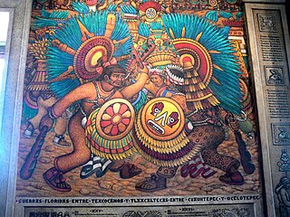
The Tlaxcalans, or Tlaxcaltecs, are a Nahua people who live in the Mexican state of Tlaxcala.

<span class="mw-page-title-main">Apizaco</span> Municipality in Tlaxcala, Mexico

Apizaco is a city in Apizaco Municipality located near the geographic center of the Mexican state of Tlaxcala, approximately 25 minutes by car from the state's capital city of Tlaxcala. Those seeking to reach the port of Veracruz by railroad from Mexico City must travel through Apizaco. The city began because of its location on this railroad.

<span class="mw-page-title-main">Chiautempan</span> City in Tlaxcala, Mexico

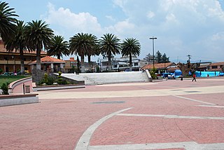
Santa Ana Chiautempan is a city in Chiautempan Municipality in the south-central part of the Mexican state of Tlaxcala. The city serves as the municipal seat of the municipality, which covers an area of 66.21 km². At the 2005 census it had a population of 46,776 inhabitants, the fourth-largest community in the state in population. The city lies at the extreme western end of the municipality, which had a census population of 63,300 inhabitants.

<span class="mw-page-title-main">Terrenate, Tlaxcala</span>

Terrenate is a city, and the surrounding municipality of the same name, in the Mexican state of Tlaxcala. It is situated in the highest part of the state, at 2,680 metres above sea level. "Terrenate" is a Nahuatl name meaning "land the colour of masa".

<span class="mw-page-title-main">Temoaya</span> Municipality in State of Mexico, Mexico

Temoaya is a municipality in the State of Mexico, Mexico. It's municipal seat is the town of Temoaya which is the sixth largest town in the municipality. It is located 18 kilometres (11 mi) from Toluca and 85 kilometres (53 mi) from Mexico City. It is known for its large ethnic Otomi population, the Centro Ceremonial Otomí and its tradition of making Persian style rugs using Mexican designs.

Xicotencatl II Axayacatl, also known as Xicotencatl the Younger, was a prince and warleader, probably with the title of Tlacochcalcatl, of the pre-Columbian state of Tlaxcala at the time of the Spanish conquest of the Aztec Empire.

Tepetlaoxtoc de Hidalgo is a town and the seat of the municipality of Tepetlaoxtoc, which contains the archeological site of Tepetlaoxtoc, in the State of Mexico in Mexico. The name Tepetlaoxtoc comes from Náhuatl and means in limestone caves, and is used interchangeably to refer to the town, the municipality and the archeological ruins. 'de Hidalgo' was added to the town's name to honor Miguel Hidalgo who began the Mexican War of Independence. It is located about 100 km northeast of Mexico City.

<span class="mw-page-title-main">Tlalmanalco</span> Municipality in State of Mexico, Mexico

Tlalmanalco is a municipality located in the far south-eastern part of the State of Mexico. The municipal seat and second largest town in the municipality is the town of Tlalmanalco de Velázquez The name is from the Nahuatl language, meaning “flat area.” The municipality's seal shows flat land, with a pyramid on it, representing its pre-Hispanic history, surrounded by small mountains, which is how the area was represented in Aztec codices. The municipality is bordered by the municipalities of Chalco, Ixtapaluca, Cocotitlan, Temamatla, Tenango del Aire, Ayapango and Amecameca. It also shares a border with the neighboring state of Puebla. Much of the municipality borders the Iztaccihuatl-Popocatepetl National Park. For this reason, Iztaccihuatl volcano dominates the landscape. The town has been designated as a “Pueblo con Encanto” by the government of the State of Mexico.

<span class="mw-page-title-main">Ixtenco Municipality</span> Municipality in Tlaxcala, Mexico

Ixtenco Municipality is a municipality in the Mexican state of Tlaxcala in south-eastern Mexico.

<span class="mw-page-title-main">Santa Ana Nopalucan</span> Municipality in Tlaxcala, Mexico

Santa Ana Nopalucan is a municipality in the Mexican state of Tlaxcala in south-eastern Mexico.

<span class="mw-page-title-main">Sawdust carpet</span> Religious street decoration

Sawdust carpets are one or more layers of colored sawdust, and sometimes other additional materials, laid on the ground as decoration. Sawdust carpets are traditionally created to greet a religious procession that walks over them. The tradition of decorating streets in this fashion began in Europe and was brought to the Americas by the Spanish. The tradition is still found in Mexico, Central America, parts of South America and parts of the United States, but it is strongest in Mexico and Central America.

<span class="mw-page-title-main">Ixtenco</span> Place in Tlaxcala, Mexico

Ixtenco is located in Ixtenco Municipality in the southeast of the Mexican state of Tlaxcala. It is a traditional Otomi community, which has conserved its agricultural economic base and various traditions. However, it is one of the poorest and least populated of the state's municipalities. The town's main landmark is the San Juan Bautista Parish and the municipality contains the remains of colonial era haciendas. The municipality lies on an old lava flow from the nearby La Malinche Volcano, which provides its volcanic soil, but because of the destruction of forests and overgrazing, erosion is a significant problem.

<span class="mw-page-title-main">Handcrafts and folk art in Tlaxcala</span> Artistic traditions of Tlaxaca, Mexico

Tlaxcala handcrafts and folk art is that which comes from the smallest state in Mexico, located in the center-east of the country. Its best-known wares are the "canes of Apizaco", sawdust carpets and the making of Saltillo-style serapes. However, there are other handcraft traditions, such as the making of pottery, including Talavera type wares, cartoneria, metalworking and stone working. The state supports artisans through the activities of the Fideicomiso Fondo de la Casa de las Artesanía de Tlaxcala

References

  1. 1 2 3 4 "Resumen municipal". Microrregiones. Mexico: SEDESOL. 2014. Retrieved June 11, 2014.
  2. 1 2 3 4 Tlaxcala: Guía para descubrir los encantos del estado. Mexico City: Editorial Océano de México. 2010. p. 85. ISBN   9786074003222.
  3. 1 2 3 4 5 6 7 8 9 10 11 12 13 14 15 16 17 18 19 20 21 22 "Tzompantepec". Enciclopedia de los Municipios y Delegaciones de México Estado de Tlaxcala. Mexico: INAFED. 2010. Retrieved June 11, 2014.
  4. 1 2 3 4 5 6 7 "Monumentos Históricos". Mexico: State of Tlaxcala. Retrieved June 11, 2014.
  5. "Fiestas Populares". Mexico: State of Tlaxcala. Retrieved June 11, 2014.
  6. 1 2 3 4 5 6 "Geografía". Mexico: State of Tlaxcala. Retrieved June 11, 2014.
  7. 1 2 3 "Informe Anual Sobre La Situación de Pobreza y Rezago Social" (PDF). Mexico: SEDESOL. 2014. Retrieved June 11, 2014.
  8. "Toponimia municipal". Mexico: State of Tlaxcala. Retrieved June 11, 2014.
  9. 1 2 3 4 "Época Prehíspanica". Mexico: State of Tlaxcala. Retrieved June 11, 2014.
  10. 1 2 "La Colonia". Mexico: State of Tlaxcala. Retrieved June 11, 2014.
  11. "La Independencia". Mexico: State of Tlaxcala. Retrieved June 11, 2014.
  12. 1 2 "La Reforma". Mexico: State of Tlaxcala. Retrieved June 11, 2014.