U.S. Route 52 (US 52) is a major United States highway in the central United States that extends from the northern to southeastern region of the United States. Contrary to most other even-numbered U.S. Highways, US 52 primarily follows a northwest–southeast route, and is signed north–south or east–west depending on the local orientation of the route. The highway's northwestern terminus is at Portal, North Dakota, on the Canadian border, where it continues as Saskatchewan Highway 39. Its southeastern terminus is in Charleston, South Carolina, at Number 2 Meeting Street and White Point Gardens along the Charleston Harbor.

Route 1A is a north–south state highway in Massachusetts. It is an alternate route to U.S. 1 with three signed sections and two unsigned sections where the highway is concurrent with its parent. Due to the reconfiguration of tunnel interchanges brought on by the completion of the Big Dig, Route 1A is discontinuous in the downtown Boston area. Vehicles entering Downtown Boston via the Sumner Tunnel must take I-93 north to the exit for Government Center and make a U-turn to access the entrance ramp to I-93 south and vice versa.
U.S. Route 65 is a north–south United States highway in the southern and midwestern United States. The southern terminus of the route is at U.S. Route 425 in Clayton, Louisiana. The northern terminus is at Interstate 35 just south of Interstate 90 in Albert Lea, Minnesota. Parts of its modern route in Iowa and historic route in Minnesota follow the old Jefferson Highway.

U.S. Route 29 is a north–south United States highway that runs for 1,036 miles (1,667 km) from Pensacola, Florida to the western suburbs of Baltimore, Maryland in the Southern United States, connecting the Florida Panhandle to the Baltimore-Washington metropolitan area. This highway takes on an overall northeast path, from its southern terminus at US 90 and US 98 in Pensacola, Florida to its northern terminus at Maryland Route 99 in Ellicott City, Maryland.
U.S. Route 222 is a U.S. Highway that is a spur of US 22. It runs for 95 miles (153 km) from US 1 in Conowingo, Maryland to Interstate 78 (I-78)/Pennsylvania Route 309 in Dorneyville, Pennsylvania. US 222 is almost entirely in Pennsylvania, and serves as the state's principal artery between the Lancaster and Reading areas and the Lehigh Valley. US 222 heads north from US 1 in Conowingo and soon crosses from Maryland into Pennsylvania, continuing north through rural areas and passing through Quarryville and Willow Street before reaching Lancaster. The route passes through Lancaster on a one-way pair of city streets before becoming a freeway at US 30 north of the city. The US 222 freeway heads northeast, crossing US 322 in Ephrata and coming to an interchange with the Pennsylvania Turnpike (I-76). US 222 bypasses Reading to the west, where it meets US 422. The freeway section ends past Reading and the route continues northeast through rural areas, with a freeway bypass of Kutztown. US 222 bypasses Trexlertown on a multilane divided expressway before coming to its northern terminus at I-78/PA 309 in Dorneyville, where the US 222 right-of-way continues into Allentown as PA 222.
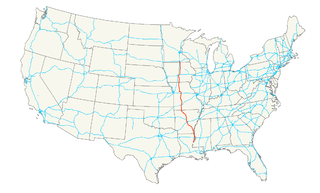
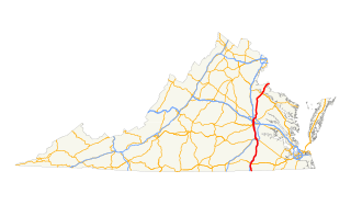
U.S. Route 522 is a spur route of US 22 in the U.S. states of Virginia, West Virginia, Maryland, and Pennsylvania. The U.S. Highway travels in a north-south direction, and runs 308.59 miles (496.63 km) from US 60 near Powhatan, Virginia, to its northern terminus at US 11 and US 15 near Selinsgrove, Pennsylvania. US 522 serves many small cities and towns in the Piedmont, Blue Ridge Mountains, and northern Shenandoah Valley of Virginia. The highway serves the Virginia communities of Goochland, Mineral, Culpeper, the town of Washington, and Front Royal and the independent city of Winchester. US 522 then follows the Ridge-and-Valley Appalachians north and then east through the Eastern Panhandle of West Virginia, a 2-mile-wide (3.2 km) stretch of Western Maryland, and South Central Pennsylvania to its terminus in the Susquehanna Valley. The highway serves Berkeley Springs, West Virginia; Hancock, Maryland; and the Pennsylvania communities of McConnellsburg, Mount Union, Lewistown, and Middleburg.
Interstate 395 (I-395) in Washington, D.C., and Virginia is a 13.39-mile-long (21.55 km) spur route of I-95 that begins at an interchange with I-95 in Springfield and ends at an interchange with U.S. Route 50 in northwest Washington, D.C. It passes underneath the National Mall near the U.S. Capitol and ends at a junction with US 50 at New York Avenue, roughly one mile (1.6 km) north of the 3rd Street Tunnel. Despite its proximity to I-395 in Maryland, the route is unrelated and unconnected.
Interstate 395 (I-395) is an Interstate Highway in the U.S. state of Maryland. Known as Cal Ripken Way, the highway runs 1.33 miles (2.14 km) from I-95 north to Howard Street and Camden Street in Baltimore. I-395 is a spur that heads north from I-95 over the Middle Branch of the Patapsco River toward Downtown Baltimore, where it provides access to the Inner Harbor and the Baltimore Convention Center. The Interstate also serves the Camden Yards Sports Complex, which contains M&T Bank Stadium and Oriole Park at Camden Yards, homes of the Baltimore Ravens and Baltimore Orioles, respectively. I-395 also serves as the southern terminus of Martin Luther King Jr. Boulevard, an urban arterial that provides a western bypass of downtown Baltimore and connects I-95 with U.S. Route 40, US 1, and I-83. The Interstate is maintained by the Maryland Transportation Authority (MDTA) and, like all Interstates, is a part of the National Highway System.
Route 114 is a 45.7-mile-long (73.5 km) numbered state highway in the U.S. state of Rhode Island. It connects the city of Newport to the city of Woonsocket. Route 114 was a major north–south artery for its entire length until the arrival of the Interstate Highway System. It is still a major commercial corridor on Aquidneck Island and in northern Rhode Island.
Route 126 is a 14.3-mile-long (23.0 km) state highway in the U.S. state of Rhode Island. Route 126 is a heavily traveled route in Pawtucket. Its southern terminus is at U.S. Route 1 in Providence, and its northern terminus is at the Massachusetts border where it continues as Massachusetts Route 126.
Interstate 95 (I-95) in Maryland is a major highway that runs 109.01 miles (175.43 km) diagonally from northeast to southwest, from Maryland's border with Delaware, to the Woodrow Wilson Bridge, entering the District of Columbia and reaching Virginia. The route is one of the most traveled Interstate Highways in Maryland, especially between Baltimore and Washington, D.C., despite alternate routes along the corridor, such as the Baltimore-Washington Parkway, U.S. Route 1, and US 29. Portions of the highway, including the Fort McHenry Tunnel, are tolled.
U.S. Route 50 (US 50) is a major east–west route of the U.S. Highway system, stretching just over 3,000 miles (4,800 km) from Ocean City, Maryland, on the Atlantic Ocean, to West Sacramento, California, nearly to the Pacific Ocean. In the District of Columbia, US 50 passes between Arlington County, Virginia, and Prince George's County, Maryland, predominantly along surface streets, including a part of Constitution Avenue along the National Mall.
U.S. Route 301 is a part of the U.S. Highway System that runs from Sarasota, Florida to Biddles Corner, Delaware. In Virginia, the U.S. Highway runs 142.70 miles (229.65 km) from the North Carolina state line near Skippers north to the Maryland state line at the Potomac River near Dahlgren. US 301 forms the local complement to Interstate 95 (I-95) from Emporia to Petersburg. The U.S. Highway runs concurrently with US 1 between Petersburg and the state capital of Richmond, where the highways form one of the main north–south avenues. US 301 continues north concurrent with Virginia State Route 2 to Bowling Green, forming an eastern alternative to I-95 and US 1 north of Richmond. At Bowling Green, which is connected to I-95 by SR 207, US 301 becomes the primary highway connecting Richmond and the Northern Neck with Southern Maryland. US 301 was constructed in four main segments: as the original SR 24 and then US 17-1 south of Petersburg, as US 1 from Petersburg to Richmond, as SR 2 from Richmond to Bowling Green, and as part of SR 207 toward Dahlgren. US 301 replaced US 17-1 in the early 1930s and was extended from Petersburg north along its current course into Maryland when the Potomac River Bridge was completed in 1940.
U.S. Route 1 (US 1) is a major north–south U.S. Highway that serves the East Coast of the United States. In the U.S. state of Virginia, US 1 runs north–south through South Hill, Petersburg, Richmond, Fredericksburg, and Alexandria on its way from North Carolina to the 14th Street Bridge into the District of Columbia. It is completely paralleled by Interstate Highways in Virginia – Interstate 85 (I-85) south of Petersburg, I-95 north to Alexandria, and I-395 into the District – and now serves mainly local traffic. At its north end, on the approach to the 14th Street Bridge, US 1 is concurrent with I-395; the rest of US 1 is on surface roads.
U.S. Route 1 (US 1) is the easternmost and longest of the major north–south routes of the older 1920s era United States Numbered Highway System, running from Key West, Florida to Fort Kent, Maine. In the U.S. state of Maryland, an 80.86-mile (130.13 km) segment of the route runs through central Maryland between Mount Rainier and Rising Sun.
Maryland Route 140 is a 49-mile (79 km) state highway in the U.S. state of Maryland. The route runs from U.S. Route 1 and US 40 Truck in Baltimore northwest to the Pennsylvania border, where the road continues into that state as Pennsylvania Route 16. MD 140 passes through the northern part of central Maryland, connecting Baltimore, Pikesville, Reisterstown, Westminster, Taneytown, and Emmitsburg.
Several special routes of U.S. Route 1 exist, from Florida to Maine. In order from south to north, separated by type, these special routes are as follows.

U.S. Route 221 (US 221) in the U.S. state of Georgia is a south–north U.S. Highway. It travels from the Florida border near the Quitman area to the South Carolina state line, north of Pollards Corner. The highway connects North Central Florida with Upstate South Carolina.
Twenty-four business routes of Interstate 15 exist. Former routes also exist.
A total of at least sixteen special routes of U.S. Route 460 exist and at least six have been deleted.


