
Bloemfontein is the capital city of the Free State Province of South Africa; and, as the judicial capital of the nation, one of South Africa's three national capitals and is the seventh largest city in South Africa. Situated at an elevation of 1,395 m (4,577 ft) above sea level, the city is home to approximately 520,000 residents and forms part of the Mangaung Metropolitan Municipality which has a population of 747,431. It was one of the host cities for the 2010 FIFA World Cup.

Kimberley is the capital and largest city of the Northern Cape Province of South Africa. It is located approximately 110 km east of the confluence of the Vaal and Orange Rivers. The city has considerable historical significance due to its diamond mining past and the siege during the Second Anglo-Boer war. British businessmen Cecil Rhodes and Barney Barnato made their fortunes in Kimberley, and Rhodes established the De Beers diamond company in the early days of the mining town.

East London is a city on the southeast coast of South Africa in the Buffalo City Metropolitan Municipality of the Eastern Cape province. The city lies on the Indian Ocean coast, largely between the Buffalo River and the Nahoon River, and hosts the country's only river port. As of 2011, East London had a population of over 267,000 with over 755,000 in the metropolitan area.

The Eastern Cape is one of the provinces of South Africa. Its capital is Bhisho, but its two largest cities are East London and Port Elizabeth.

North West is a province of South Africa. Its capital is Mahikeng. The province is located to the west of the major population centre of Gauteng.
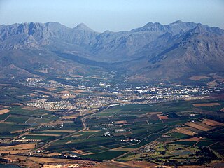
Stellenbosch is a town in the Western Cape province of South Africa, situated about 50 kilometres east of Cape Town, along the banks of the Eerste River at the foot of the Stellenbosch Mountain. It is the second oldest European settlement in the province, after Cape Town. The town became known as the City of Oaks or Eikestad in Afrikaans and Dutch due to the large number of oak trees that were planted by its founder, Simon van der Stel, to grace the streets and homesteads.

Knysna is a town with 85,708 inhabitants as of 2019 in the Western Cape Province of South Africa and is part of the Garden Route. It lies 34 degrees south of the equator, and is 55 kilometres east from the city of George on the N2 highway, and 33 kilometres west of the town of Plettenberg Bay on the same road.

Ndola is the second largest city in Zambia in terms of infrastructural development and third in terms of size and population, with a population of 475,194, after the capital, Lusaka, and Kitwe. It is the industrial and commercial center of the Copperbelt, Zambia's copper-mining region, and capital of Copperbelt Province. It lies just 10 kilometres (6.2 mi) from the border with DR Congo. It is also home to Zambia's first modern stadium, the Levy Mwanawasa Stadium.

Welkom is the second-largest city in the Free State province of South Africa, located about 140 kilometres (90 mi) northeast of Bloemfontein which is the provincial capital. Welkom is also known as Circle City, City Within A Garden, Mvela and Matjhabeng. The city's Sotho name, Matjhabeng means 'where nations meet', derived from the migrant labour system, where people of various countries such as Lesotho, Malawi and Mozambique etc. met to work in the mines of the gold fields.

Vryburg is a large agricultural town with a population of 48,400 situated in the Dr Ruth Segomotsi Mompati District Municipality of the North West Province of South Africa. It is the seat and the industrial and agricultural heartland of the district of the Bophirima region.
The "garden city" suburb of Pinelands is a middle class suburb located on the edge of the southern suburbs of Cape Town, South Africa, neighbouring the suburb of Thornton, and is known for its large thatched houses and green spaces. The suburb is primarily residential and is often praised for its peacefulness and abundance of trees. Pinelands is one of the few areas in Cape Town in which sale of alcohol to the public is prohibited, but some clubs have private liquor licenses. It is a popular place for senior citizens to retire to. While there are several retirement homes in the suburb, younger people are increasingly moving in.

Somerset West is a town in the Western Cape, South Africa. Organisationally and administratively it is included in the City of Cape Town metropolitan municipality as a suburb of the Helderberg region . The vehicle registration code for Somerset West is CFM and the post code is 7130 for street addresses, and 7129 for post office boxes.

New Brighton is a township in the Eastern Cape, South Africa. It forms part of the greater township of Ibhayi and the Nelson Mandela Bay Metropolitan Municipality which governs Port Elizabeth and its surroundings.

Brackenfell is a town in the Western Cape province of South Africa at the gateway to the Cape Winelands. Organisationally and administratively it is included in the City of Cape Town Metropolitan Municipality as a Northern Suburb and is about 30 kilometres (19 mi) east of Cape Town City Bowl. In Brackenfell a variety of property situated on the slopes of the Bottelary Hills can be found.

Durbanville is a town in the Western Cape province of South Africa, part of the greater City of Cape Town metropolitan area. Durbanville is a semi-rural residential suburb on the northern outskirts of the metropolis and is surrounded by farms producing wine and wheat.

Kleinzee or Kleinsee is a small Village on the west coast of the Northern Cape province in South Africa,
Calvinia is a regional town in the Northern Cape province of South Africa named after the French religious reformer Jean Calvin. The town falls under the Hantam Local Municipality which forms part of the Namakwa District Municipality. The Calvinia district is part of the Great Karoo region of South Africa. The town is just south of the Hantam mountains on the banks of the Oorlogskloof River.

Daniëlskuil is a town in ZF Mgcawu District Municipality in the Northern Cape province of South Africa.
Delportshoop is a town in Frances Baard District Municipality in the Northern Cape Province of South Africa. It lies next to the Vaal River. The Harts River runs by closely.
Lime Acres is a town in Kgatelopele Local Municipality in the Northern Cape province of South Africa.


