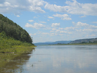
The Amur River or Heilong River is a perennial river in Northeast Asia, forming the natural border between the Russian Far East and Northeast China. The Amur proper is 2,824 km (1,755 mi) long, and has a drainage basin of 1,855,000 km2 (716,000 sq mi). If including its main stem tributary, the Argun, the Amur is 4,444 km (2,761 mi) long, making it the world's tenth longest river.

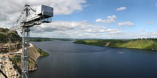
The Zeya is a northern, left tributary of the Amur in Amur Oblast, Russia. It is 1,242 km (772 mi) long, and has a drainage basin of 233,000 km2 (90,000 sq mi). The average flow of the river is 1,810 m3/s (64,000 cu ft/s).

The Olyokma is a tributary of the Lena in eastern Siberia.

The Bureya is a south-flowing, left tributary of the Amur river in Russia. It is 623 kilometres (387 mi) long, and has a drainage basin of 70,700 square kilometres (27,300 sq mi). Its name comes from the Evenk word birija, meaning river.

The Selemdzha is a river in the Amur Region of Russia. It is the biggest, left tributary of the Zeya. The length of the river is 647 km. The area of its basin 68,600 km².
The Turan Range is a range of mountains in far North-eastern Russia. Administratively it belongs partly to Amur Oblast and partly to the Khabarovsk Krai of the Russian Federation.

The Timpton is a river in Sakha Republic (Yakutia), Russia. It is a right tributary of the Aldan River of the Lena basin. It has a length of 644 kilometres (400 mi) and a drainage basin area of 44,400 square kilometres (17,100 sq mi). There are no settlements near its banks except for Nagorny village.

The Amazar is a river in Zabaykalsky Krai, Russia. It is a tributary of the Amur, with a length of 290 kilometres (180 mi) and a drainage basin area of 11,100 square kilometres (4,300 sq mi).

The Gur is a river in Khabarovsk Krai, Russia. It is the 9th longest tributary of the Amur, with a length of 349 kilometres (217 mi) and a drainage basin area of 11,800 square kilometres (4,600 sq mi). The river was known as "Khungari" (Хунгари) until the 1972 Renaming of geographical sites in the Russian Far East. The town of Gurskoe, as well as the villages of Kenai, Uktur and Snezhny are located by the river. Gold mining is being developed in the river basin.

The Gorin, also known as "Goryun" and "Garin", is a river in Khabarovsk Krai, Russia. It is the 8th longest tributary of the Amur, with a length of 390 kilometres (240 mi) and a drainage basin area of 22,400 square kilometres (8,600 sq mi).

The Yam-Alin is a mountain range in Amur Oblast and Khabarovsk Krai, Russian Far East.

The Nimelen is a river in Khabarovsk Krai, Russia. It is the longest tributary of the Amgun, with a length of 311 kilometres (193 mi) and a drainage basin area of 14,100 square kilometres (5,400 sq mi).

The Nora is a river in Amur Oblast, Russia. It is the 2nd longest tributary of the Selemdzha after the Ulma, with a length of 305 kilometres (190 mi) and the first in drainage basin area, with 16,700 square kilometres (6,400 sq mi). The name originated in "nehru", the Evenki word for "grayling".

The Byssa is a river in Selemdzhinsky District, Amur Oblast, Russia. It is the third longest tributary of the Selemdzha, with a length of 235 kilometres (146 mi) and with 6,370 square kilometres (2,460 sq mi) the third in drainage basin area, after the Orlovka. The name of the river originated in the Evenki language.

The Orlovka, also known as Mamyn, is a river in Mazanovsky District, Amur Oblast, Russia. It is the 4th longest tributary of the Selemdzha after the Byssa, with a length of 208 kilometres (129 mi) and the second in drainage basin area, with 11,300 square kilometres (4,400 sq mi).

The Ilga is a river in Irkutsk Oblast, Russia. It is the 32nd longest tributary of the Lena with a length of 289 kilometres (180 mi) and a drainage basin area of 10,400 square kilometres (4,000 sq mi).

The Tutura is a river in Irkutsk Oblast, Russia. It is a tributary of the Lena with a length of 222 kilometres (138 mi) and a drainage basin area of 7,300 square kilometres (2,800 sq mi).

The Tayura is a river in Irkutsk Oblast, Russia. It is a tributary of the Lena with a length of 216 kilometres (134 mi) and a drainage basin area of 5,720 square kilometres (2,210 sq mi). The river is crossed by the Baikal-Amur Mainline and the interregional highway 25K-258 Ust-Kut - Severobaikalsk.

The Bolshoy Patom, "Big Patom", is a river in Irkutsk Oblast, Russia. It is the 11th longest tributary of the Lena with a length of 570 kilometres (350 mi) and a drainage basin area of 28,400 square kilometres (11,000 sq mi).
The Namyndykan is a river in Magadan Oblast, Russia. It has a length of 199 kilometres (124 mi) and a drainage basin of 2,410 square kilometres (930 sq mi).


