Umhlali

Last updated
Umhlali
eMhlali
South Africa KwaZulu-Natal location map.svg
Red pog.svg
Umhlali
South Africa adm location map.svg
Red pog.svg
Umhlali
Coordinates: 29°28′39″S31°13′07″E / 29.47750°S 31.21861°E / -29.47750; 31.21861
Country South Africa
Province KwaZulu-Natal
District iLembe
Municipality KwaDukuza
Area
[1]
  Total2.26 km2 (0.87 sq mi)
Population
 (2011) [1]
  Total338
  Density150/km2 (390/sq mi)
Racial makeup (2011)
[1]
   Black African 48.2%
   Indian/Asian 14.8%
   White 36.7%
  Other0.3%
First languages (2011)
[1]
   English 45.0%
   Zulu 31.7%
   Afrikaans 6.5%
  Other6.1%
Time zone UTC+2 (SAST)
Postal code (street)
4390
PO box
4390

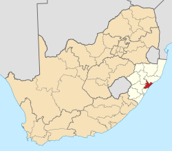
Umhlali (Zulu: eMhlali) is a village on the North Coast of the KwaZulu-Natal province of South Africa, just inland from Salt Rock and approximately 50 km north-west of Durban. The name of the village, "Umhlali" derives from the Zulu name of the Monkey Orange tree - a small semi-deciduous tree that is predominant along the banks of the uMhlali River, north of the village. [2]

Contents

History

[3]

The village of Umhlali, was established by British and Scottish Byrne settlers in 1850 and was originally Fort William, as it was the site of a fort. [4]

It was later renamed Umhlali which is the Zulu name for the Monkey Orange tree, which grew plentifully along the banks of the uMhlali River but it was also locally referred to it as the “place of waiting” because settlers and locals would have to wait on the banks before crossing the river on a northward journey.

At that time, the nearby coastal town of Ballito was a small coastal village consisting of a few beach shacks whilst Umhlali was the hub of the farming community with the heart of the village being the bustling main road (the current R102 route) consisting of a bank, post office, supermarket, hairdresser, car dealership, farmers’ co-op and the Lali Hotel. Until the new retail developments launched in Ballito, Umhlali was initially one of the only places in the Dolphin Coast locally to buy groceries, collect post, do banking, fill up with petrol and go to school.

A significant landmark in Umhlali, Umhlali Preparatory School, which opened its doors on 11 February 1918, still exists alongside the R102 main road and is still a highly esteemed and popular school on the Dolphin Coast today. [5]

Today

Today Umhlali still remains a quaint sugar-producing village, mostly supported by the surrounding sugarcane farms and industry. It is one of the few very settlements along the North Coast of KwaZulu-Natal that has remained unaffected by the rapid urban expansion in the region.

Umhlali consists of a post office, petrol station, Coastal Farmer's Co-Op, a small lifestyle centre named Sugar Village, small cafes and restaurants, automotive services and agricultural stores amongst other facilities. [6] [7] [8]

Geography

Located in the hilly countryside, Umhlali lies just south of the uMhlali River after which it is named after. The village is positioned approximately 3 km south of Shakaskraal (north of the uMhlali River), 3 km west of the coastal village of Salt Rock and 9 km north-west of the coastal town of Ballito. [9]

Umhlali also forms part of the Dolphin Coast which incorporates Ballito, Shaka’s Rock, Salt Rock, Tinley Manor, Zinkwazi Beach and Shakaskraal.

Infrastructure

Rail

The main Metrorail route between Durban in the south-east (via oThongathi) and KwaDukuza in the north-east (via Shakaskraal), known as the North Coast Line, has a station in the village, namely the Umhlali railway station.

Roads

Umhlali lies at the junction of the R102 and Salt Rock Road. The R102 bisects the village in a northsouth direction, connecting Shakaskraal with oThongathi, while Salt Rock Road connects Umhlali with Salt Rock to the east and provides access to the N2 highway which runs northsouth from KwaDukuza to Durban.

Related Research Articles

<span class="mw-page-title-main">KwaZulu-Natal</span> Province in South Africa

KwaZulu-Natal is a province of South Africa that was created in 1994 when the government merged the Zulu bantustan of KwaZulu and Natal Province.

KwaDukuza, previously known as Stanger, is a city in KwaZulu-Natal, South Africa. In 2006, the municipal name was changed to KwaDukuza, but the Zulu people in the area called it "Dukuza" well before then.

<span class="mw-page-title-main">Ballito</span> Place in KwaZulu-Natal, South Africa

Ballito is an affluent coastal town located in KwaZulu-Natal, South Africa. Ballito is about 40 kilometres (25 mi) north of Durban and 24 kilometres south of KwaDukuza. It forms part of the KwaDukuza Local Municipality, and iLembe District Municipality. Dolphins and Whales are common on this stretch of the North Coast shoreline, hence the nickname Dolphin Coast. The name of the town Ballito is named after the Italian word for "small ball".

Umtentweni, also officially known as eMthenteni, is a small coastal resort on the South Coast of KwaZulu-Natal, South Africa, between the Mzimkulu River (the great home of all rivers) and the Mtentweni River. It forms part of the coastal town of Port Shepstone in the Ray Nkonyeni Local Municipality, KwaZulu-Natal, South Africa. It is a relatively clean and quiet residential resort; it has become an attractive destination for people aiming to get away from city life. Most of the village is filled with complexes, flats, bed and breakfasts and suburban-style houses. Twenty years ago the whole of Umtentweni consisted of a lot of greenery and wildlife. All this has changed due to the growing popularity of this small resort and the constant clearing for new housing.

<span class="mw-page-title-main">Mount Edgecombe</span> Place in KwaZulu-Natal, South Africa

Mount Edgecombe or Mt Edgecombe is a town in KwaZulu-Natal, South Africa, situated just north of Durban, which forms part of eThekwini, the Greater Durban Metropolitan area. Much of the suburb is cordoned off as a gated settlement comprising resorts, golf courses and a retirement home. It was previously a sugar growing area. The population increased by 89% between 2001 and 2011 from 3,874 to 7,323. Its name is derived from the Earl of Mount Edgecombe in Cornwall, United Kingdom.

oThongathi Place in KwaZulu-Natal, South Africa

oThongathi, previously and still commonly known as Tongaat, is a town in KwaZulu-Natal, South Africa, about 40 kilometres (25 mi) north of Durban and 28 kilometres (17 mi) south of KwaDukuza. It now forms part of eThekwini Metropolitan Municipality, or the Greater Durban area. The area is home to the oldest Indian community in South Africa, having been where the first indentured Indian laborers settled in 1860 to work in the sugar-cane plantations. Much of the architectural style in the town was the work of Ivan Mitford-Barberton, and many buildings are in the Cape Dutch style of architecture.

eMdloti Place in KwaZulu-Natal, South Africa

eMdloti, alternatively rendered Umdloti and also known as Umdloti Beach, is a small resort village situated along the KwaZulu-Natal North Coast, South Africa. It lies at the mouth of the Mdloti River approximately 24 km north-east of Durban and 11 km north-east of uMhlanga and now forms part of eThekwini, the Greater Durban Metropolitan Municipality.

<span class="mw-page-title-main">Verulam, KwaZulu-Natal</span> Place in KwaZulu-Natal, South Africa

Verulam is a town 24 kilometres north of Durban in KwaZulu-Natal, South Africa and forms part of the eThekwini Metropolitan Municipality, governing the Greater Durban metropolitan area.

<span class="mw-page-title-main">R102 (South Africa)</span> Regional Route in South Africa

The R102 is a Regional Route in South Africa. It is the route designation for all old sections of the N2, thus it is a discontinuous road that resumes in areas where a new N2 has been constructed.

<span class="mw-page-title-main">N2 (South Africa)</span> National road in South Africa

The N2 is a national route in South Africa that runs from Cape Town through George, Gqeberha, East London, Mthatha, Port Shepstone and Durban to Ermelo. It is the main highway along the Indian Ocean coast of the country. Its current length of 2,255 kilometres (1,401 mi) makes it the longest numbered route in South Africa.

uMhlanga, KwaZulu-Natal Place in KwaZulu-Natal, South Africa

uMhlanga, alternatively rendered Umhlanga, is a residential, commercial and resort town north of Durban on the coast of KwaZulu-Natal, South Africa. It is part of the eThekwini Metropolitan Municipality, which was created in 2000 and includes the greater Durban area. The name means "place of reeds" in the Zulu language, and the correct pronunciation of "hl" in uMhlanga is similar to the Welsh "ll".

<span class="mw-page-title-main">Salt Rock</span> Place in KwaZulu-Natal, South Africa

Salt Rock is a small coastal village just north of Ballito and Shaka's Rock situated along the Dolphin Coast of KwaZulu-Natal, South Africa. It is a favorite holiday destination for many local South Africans. It is approximately located 52 kilometres north-east of Durban and 19 km south-east of KwaDukuza. Salt Rock owes much of its history to Basil Hulett and his wife Gwen who started not only the Salt Rock Hotel but went on to develop the town of Salt Rock as found today.

The M4 is a north–south metropolitan route in the eThekwini Metropolitan Municipality and partially in the KwaDukuza Local Municipality, South Africa. It runs from the N2 at the defunct Durban International Airport to Ballito via the Durban Central Business District (CBD) and uMhlanga. The sections between the airport and the southern edge of the CBD, and between the northern edge of the CBD and the exit to uMhlanga are classified as freeway. On the section from the southern edge of the CBD to the Bram Fischer Street/Soldier's Way junction, the M4 is cosigned with the R102.

Shaka's Rock is a beachside town situated along the North Coast of KwaZulu-Natal, South Africa.

<span class="mw-page-title-main">Shakaskraal</span> Place in KwaZulu-Natal, South Africa

Shakaskraal is a town in Ilembe District Municipality in the KwaZulu-Natal province of South Africa. The town is dominated by local businesses and informal traders and main activities located in and nearby is sugar cane farming.

<span class="mw-page-title-main">South Coast (KwaZulu-Natal)</span> Coastal region in KwaZulu-Natal, South Africa

KwaZulu-Natal South Coast is a region along the southern stretch of coastline of KwaZulu-Natal, South Africa, south of the coastal city of Durban.

<span class="mw-page-title-main">North Coast (KwaZulu-Natal)</span> Coastal region in KwaZulu-Natal, South Africa

The KwaZulu-Natal North Coast, better known as the North Coast is a coastal region north of Durban in KwaZulu-Natal, South Africa. It stretches from Zinkwazi Beach in the north to Zimbali near Ballito in the south. The coastal region is governed by the KwaDukuza Local Municipality, forming part of the iLembe District Municipality.

The M27 also known as Jabu Ngcobo Drive or Old Inanda Road is a metropolitan route in the eThekwini Metropolitan Municipality, South Africa linking Inanda to Verulam and eMdloti, north of Durban.

<span class="mw-page-title-main">Westbrook, South Africa</span> Place in KwaZulu-Natal, South Africa

Westbrook, also known as Westbrook Beach is a coastal village on the North Coast of the KwaZulu-Natal province of South Africa, approximately 35 kilometres (22 mi) north-east of Durban and 7 kilometres (4 mi) east of oThongathi.

References

  1. 1 2 3 4 "Main Place Umhlali". Census 2011. Archived from the original on 2021-04-29. Retrieved 2023-03-25.
  2. "Umhlali". www.sa-venues.com. Archived from the original on 2022-07-04. Retrieved 2023-03-25.
  3. "A Brief History of Umhlali". Sugar Village, Umhlali. Retrieved 2023-03-30.
  4. amyjenkins (2018-08-12). "Umhlali - What's in a name?". North Coast Courier. Retrieved 2023-03-30.
  5. "Umhlali Preparatory School". Umhlali Preparatory School. Retrieved 2023-03-30.
  6. "Umhlali". www.sa-venues.com. Retrieved 2023-03-30.
  7. "Sugar Village, Umhlali". Sugar Village, Umhlali. Retrieved 2023-03-30.
  8. "Branches". Coastals. Retrieved 2023-03-30.
  9. "Travel South Africa". distancecalculator.co.za. Archived from the original on 2022-11-10. Retrieved 2023-03-25.