
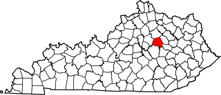
Callaway County is a county located in the U.S. state of Missouri. As of the 2010 United States Census, the county's population was 44,332. Its county seat is Fulton. With a border formed by the Missouri River, the county was organized November 25, 1820, and named for Captain James Callaway, grandson of Daniel Boone. The county has been historically referred to as "The Kingdom of Callaway" after an incident in which some residents confronted Union troops during the U.S. Civil War.
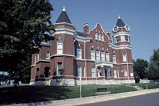
Fulton County is the westernmost county in the U.S. state of Kentucky, with the Mississippi River forming its western boundary. As of the 2010 census, the population was 6,813. Its county seat is Hickman. The county was formed in 1845 from Hickman County, Kentucky and named for Robert Fulton, the inventor of the steamboat.

Fulton is a home rule-class city in Fulton County, Kentucky, United States. The population was 2,445 at the 2010 census, down from 2,775 at the 2000 census. It was once known as the "Banana Capital of the World", because 70% of imported bananas to the U.S. used to be shipped through the city. U.S. Route 51 runs through the center of downtown. Fulton is part of the Union City-Hickman, TN–KY Micropolitan Statistical Area.

Mayfield is a home rule-class city in Graves County, Kentucky, in the United States. It is the county seat. The population was 10,024 as of the 2010 U.S. census.

U.S. Route 45 is a major north-south United States highway and a border-to-border route, from Lake Superior to the Gulf of Mexico. A sign at the highway's northern terminus notes the total distance as 1,297 miles (2,087 km).
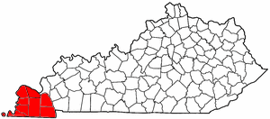
The Jackson Purchase, also known as the Purchase Region or simply the Purchase, is a region in the U.S. state of Kentucky bounded by the Mississippi River to the west, the Ohio River to the north, and the Tennessee River to the east. Although officially part of Kentucky at its statehood in 1792, the land did not come under definitive U.S. control until 1818, when Andrew Jackson purchased it from the Chickasaw Indians. Historically, this region has been considered the most "Southern" of Kentucky.

The United States District Court for the Western District of Kentucky is the federal district court for the western part of the state of Kentucky.

Camp Joe Holt was a Union base during the American Civil War in Jeffersonville, Indiana, across the Ohio River from Louisville, Kentucky, on land that is now part of Clarksville, Indiana, near the Big Eddy. It was a major staging area for troops in the Western Theatre of the War, in preparation for invading the Confederate States of America. Its establishment was the first major step performed by Kentucky Unionists to keep Kentucky from seceding to the Confederacy.
The Union City Micropolitan Statistical Area, as defined by the United States Census Bureau, is an area consisting of Obion County, Tennessee; anchored by the city of Union City, Tennessee. As of the 2000 census, the μSA had a population of 32,450.

The Confederate Memorial Gateway in Hickman, Kentucky is a historic cemetery gateway in Fulton County, Kentucky. It was funded in 1913 by the Private Robert Tyler Chapter of the United Daughters of the Confederacy. It was placed on the National Register of Historic Places in 1997.

This is a list of the National Register of Historic Places listings in Daviess County, Kentucky.
This is a list of the National Register of Historic Places listings in Clark County, Kentucky.

This is a list of the National Register of Historic Places listings in McCracken County, Kentucky.

This is a list of the National Register of Historic Places listings in Nelson County, Kentucky.
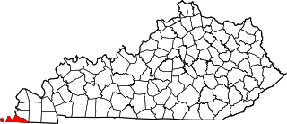
This is a list of the National Register of Historic Places listings in Fulton County, Kentucky.
National Weather Service Paducah is a weather forecast office responsible for monitoring weather conditions for 58 counties in the states of Kentucky, Illinois, Indiana and Missouri. The Paducah office is relatively new compared to others, having been built in 1984. The office is in charge of weather forecasts, warnings and local statements as well as aviation weather. It is also equipped with a WSR-88D (NEXRAD) radar, and an Automated Surface Observing System (ASOS) that greatly increase the ability to forecast.

This is a list of the National Register of Historic Places listings in Union County, Kentucky.

This is a list of the National Register of Historic Places listings in Clay County, Kentucky.
Kentucky Route 94 is a 79.816-mile-long (128.451 km) state highway in Kentucky that runs from Tennessee State Route 78 at the Tennessee state line to KY 80 southwest of the unincorporated community of Aurora via Hickman, Water Valley, and Murray.


