The Nuer language (Thok Naath) ("people's language") is a Nilotic language of the Western Nilotic group. It is spoken by the Nuer people of South Sudan and in western Ethiopia (region of Gambela). The language is very similar to Dinka and Atuot.

The South Sudan Liberation Movement (SSLM) is an armed group that operates in the Upper Nile Region of South Sudan. The group's creation was announced in November 1999 by people of the Nuer ethnicity who were in both the rebel Sudan People's Liberation Army (SPLA) and the government-allied South Sudan Defence Forces (SSDF) gathered in Waat. The SSLM was declared to be unaligned in the Second Sudanese Civil War, then entering its sixteenth year. The name "South Sudan Liberation Movement" was decided upon the next year, borrowing from the earlier Southern Sudan Liberation Movement, which existed in the 1980s.

Bentiu, also spelled Bantiu, is a city in South Sudan. It is the capital of Unity State.

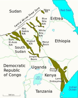
The Muglad Basin is a large rift basin in Northern Africa. The basin is situated within southern Sudan and South Sudan, and it covers an area of approximately 120,000 square kilometres (46,000 sq mi) across the two nations. It contains a number of hydrocarbon accumulations of various sizes, the largest of which are the Heglig and Unity oil fields. During the 1960s and 1970s, Chevron made the first oil discoveries in the basin near the towns of Bentiu, Malakal, and Muglad. Taken together, the Muglad and Melut rift basins account for the majority of Sudan's known oil reserves.

The Greater Upper Nile is a region of northeastern South Sudan. It is named for the White Nile, a tributary of the Nile River in North and East Africa.
Leer County is an administrative division of Unity State in the Greater Upper Nile region of South Sudan. The headquarters is in the town of Leer.
Leer is a town in the Leer County of Unity State in the Greater Upper Nile region of South Sudan. It is the capital of Leer County and was the capital of the former Southern Liech State. It is the most densely populated county in South Sudan.
Paulino Matip Nhial, or Matiep Nhial, was a military leader and politician in South Sudan.

Fangak County is an administrative area of Jonglei State in the Greater Upper Nile region of South Sudan, with headquarters in the town of Phom el Zaraf.
Mayom is a community in the Mayom County of Unity State, in the Greater Upper Nile region of South Sudan. It is located west of Bentiu. It is the headquarters of Mayom County.
Mayom County is an administrative division of Unity State in the Greater Upper Nile region of South Sudan. It is located to the west of Bentiu. The county headquarters is Mayom town.
Thar Jath is a community in Koch County, Unity State, South Sudan.

Block 5A is an oil concession in South Sudan. After oil field development began during the Second Sudanese Civil War, Block 5A was the scene of extensive fighting as rival militias struggled for control. Out of an original population of 240,000, an estimated 12,000 were killed or died of starvation and 160,000 were displaced by force. Production started in 2006. There is evidence that the environmentally sensitive marshlands beside the Nile are becoming polluted.
Adok is a port on the White Nile in the Leer County of Unity State in the Greater Upper Nile region of South Sudan. In the early 1980s Chevron Corporation found oil in Adok.
Nhialdiu is a large village in the Rubkona County of Unity State, in the Greater Upper Nile region of South Sudan. It is located about 40 kilometres (25 mi) southwest of Bentiu.
Rubkona is a town in the Rubkona County of Unity State, in the Greater Upper Nile region of South Sudan. It lies on the northern bank of the Bahr el Ghazal River, connected via the El Salaam Bridge to the state capital, Bentiu. This bridge was bombed by North Sudanese MiG-29 bomber airplanes on April 23, 2012, during the Heglig Crisis. Rubkona is the administrative center of Rubkona County.
Rubkona County is an administrative division of Unity State, South Sudan.

Northern Liech was a state in South Sudan that existed between 2 October 2015 and 22 February 2020. It was located in the Greater Upper Nile region and it bordered Ruweng to the north, Western Bieh to the east, Southern Liech to the south, Tonj to the south, and Gogrial and Twic to the west.
The War of the Peters was a conflict primarily fought between the forces of Peter Par Jiek and Peter Gadet from June 2000 to August 2001 in Unity State, Sudan. Though both were leaders of local branches of larger rebel groups that were involved in the Second Sudanese Civil War, the confrontation between the two commanders was essentially a private war. As Par and Gadet battled each other, the Sudanese government exploited the inter-rebel conflict as part of a divide and rule strategy, aimed at weakening the rebellion at large and allowing for the extraction of valuable oil in Unity State. In the end, Gadet and Par reconciled when their respective superiors agreed to merge the SPDF and SPLA.

Nuerland is the indigenous homeland and traditional territory of the Nuer people, situated largely within South Sudan between the latitudes of 7° and 10° north and longitudes of 29° and 32° east. The region encompasses parts of the Upper Nile State, Jonglei State, Unity State, and surrounding areas, characterized by a mix of swamps, savannahs, and higher ground.


