
The Pit River is a major river draining from northeastern California into the state's Central Valley. The Pit, the Klamath and the Columbia are the only three rivers in the U.S. that cross the Cascade Range.

The Feather River is the principal tributary of the Sacramento River, in the Sacramento Valley of Northern California. The river's main stem is about 73 miles (117 km) long. Its length to its most distant headwater tributary is just over 210 miles (340 km). The main stem Feather River begins in Lake Oroville, where its four long tributary forks join—the South Fork, Middle Fork, North Fork, and West Branch Feather Rivers. These and other tributaries drain part of the northern Sierra Nevada, and the extreme southern Cascades, as well as a small portion of the Sacramento Valley. The total drainage basin is about 6,200 square miles (16,000 km2), with approximately 3,604 square miles (9,330 km2) above Lake Oroville.

The Cosumnes River is a river in northern California in the United States. It rises on the western slope of the Sierra Nevada and flows approximately 52.5 miles (84.5 km) into the Central Valley, emptying into the Mokelumne River in the Sacramento-San Joaquin Delta.

The Mokelumne River is a 95-mile (153 km)-long river in northern California in the United States. The river flows west from a rugged portion of the central Sierra Nevada into the Central Valley and ultimately the Sacramento–San Joaquin River Delta, where it empties into the San Joaquin River-Stockton Deepwater Shipping Channel. Together with its main tributary, the Cosumnes River, the Mokelumne drains 2,143 square miles (5,550 km2) in parts of five California counties. Measured to its farthest source at the head of the North Fork, the river stretches for 157 miles (253 km).
The Sacramento Municipal Utility District (SMUD) is a community-owned electric utility serving Sacramento County and parts of Placer County. It is one of the ten largest publicly owned utilities in the United States, generating the bulk of its power through natural gas and large hydroelectric generation plants. SMUD's green power (renewable) energy output was estimated as 33.8% in 2020.

The Yuba River is a tributary of the Feather River in the Sierra Nevada and eastern Sacramento Valley, in the U.S. state of California. The main stem of the river is about 40 miles (64 km) long, and its headwaters are split into three major forks. The Yuba River proper is formed at the North Yuba and Middle Yuba rivers' confluence, with the South Yuba joining a short distance downstream. Measured to the head of the North Yuba River, the Yuba River is just over 100 miles (160 km) long.

Hell Hole Reservoir is an artificial, crescent-shaped lake in the Sierra Nevada mountain range 10 miles (16 km) west of Lake Tahoe in California, United States. The lake is about 3.5 miles (5.6 km) long when at full capacity.

Cache Creek is an 87-mile-long (140 km) stream in Lake, Colusa and Yolo counties, California.

Union Valley Reservoir is a reservoir in eastern El Dorado County, California, about 20 miles (32 km) northeast of Placerville. The 277,000 acre-feet (342,000,000 m3) lake is in Eldorado National Forest in the Sierra Nevada at an elevation of 4,870 feet (1,480 m).
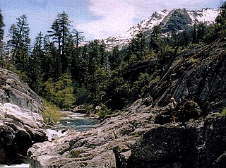
The Rubicon River is a major tributary of the Middle Fork American River in the Sierra Nevada of Northern California, west of Lake Tahoe. Its length is 60 miles (97 km) with a watershed of about 184 square miles (477 km2). The river's headwaters are in the Crystal Range of the Sierra Nevada, within the Eldorado National Forest's Desolation Wilderness. Historically, the Rubicon River was known as the South Fork of the Middle Fork of the American River.

Cherry Creek is a large, swift-flowing stream in the Sierra Nevada mountain range, and is the largest tributary of the Tuolumne River. The creek is 40 miles (64 km) long measured to its farthest headwaters; the main stem itself is 26 miles (42 km) long, draining a watershed of 234 square miles (610 km2) in the Stanislaus National Forest. Part of the drainage also extends into the northwest corner of Yosemite National Park.

Loon Lake is a reservoir in the Eldorado National Forest of El Dorado County, California, United States. The 76,200 acre⋅ft (94,000,000 m3) lake is formed by Loon Lake Dam, completed in 1963 as part of the Upper American River Project by Sacramento Municipal Utility District to conserve spring snow melt runoff for use during the summer and autumn for hydroelectric power production. Loon Lake Dam impounds water at the headwaters of Gerle Creek which, prior to the dam, flowed intermittently through (natural) Loon and Pleasant Lakes. But most of the water now stored in Loon Lake arrives from Buck Island Reservoir in the adjacent Rubicon River watershed by way of the Buck-Loon Tunnel. Nearby is Loon Lake Chalet, a popular winter recreation destination. In summer, a boat ramp for water sports and camping are available, but the area is less popular than nearby Union Valley Reservoir and Rubicon Trail.

The Bear River is a tributary of the Feather River in the Sierra Nevada, winding through four California counties: Yuba, Sutter, Placer, and Nevada. About 73 miles (117 km) long, the river flows generally southwest through the Sierra then west through the Central Valley, draining a narrow, rugged watershed of 295 square miles (760 km2).
The South Fork American River is a major tributary of the American River in El Dorado County, California, draining a watershed on the western slope of the Sierra Nevada east of Sacramento. The river begins in pristine Desolation Wilderness and flows through the Sierra Nevada foothills. The river at Coloma was the site of James Marshall's discovery of gold at Sutter's Mill on January 24, 1848, which started the California Gold Rush. The South Fork of the American is "the most popular recreation stream in the West" for whitewater rafting in North America, e.g., 80,000 visitors in 2011. Professional whitewater rafting companies have been offering commercial rafting trips on the South Fork American River since 1978.

The American River is a 30-mile (50 km)-long river in California that runs from the Sierra Nevada mountain range to its confluence with the Sacramento River in downtown Sacramento. Via the Sacramento River, it is part of the San Francisco Bay watershed. This river is fed by the melting snowpack of the Sierra Nevada and its many headwaters and tributaries, including the North Fork American River, the Middle Fork American River, and the South Fork American River.

Stony Creek is a 73.5-mile (118.3 km)-long tributary of the Sacramento River in Northern California. It drains a watershed of more than 700 square miles (1,800 km2) on the west side of the Sacramento Valley in Glenn, Colusa, Lake and Tehama Counties.

The North Fork Kings River is a 40.3-mile (64.9 km) tributary of the Kings River, in the U.S. state of California. The river's main stem is entirely within Fresno County, and its watershed drains about 387 square miles (1,000 km2) of the southern Sierra Nevada mountain range.

The Middle Fork American River is one of three forks that form the American River in Northern California. It drains a large watershed in the high Sierra Nevada west of Lake Tahoe and northeast of Sacramento in Placer and El Dorado Counties, between the watersheds of the North Fork American River and South Fork American River. The Middle Fork joins with the North Fork near Auburn and they continue downstream to Folsom Lake as the North Fork, even though the Middle Fork carries a larger volume of water.
Slab Creek Dam is a dam in the American River watershed of the central Sierra Nevada, within El Dorado County, California.

The Upper North Fork Feather River Project is a hydroelectric scheme in the Sierra Nevada of California, within Lassen and Plumas Counties. The project consists of three dams, five power plants, and multiple conduits and tunnels in the headwaters of the North Fork Feather River, a major tributary of the Feather—Sacramento River systems. The total installed capacity is 362.3 megawatts (MW), producing an annual average of 1,171.9 gigawatt hours (GWh). The project is also contracted for the delivery of irrigation water between March 31 and October 31 of each year. The project is owned and operated by Pacific Gas and Electric Company.
