Sacramento Municipal Utility District

Last updated
Sacramento Municipal Utility District
Company typeMunicipal
Industry Electricity
Founded1923
Headquarters SMUD Headquarters Building
Sacramento, California, United States
RevenueIncrease2.svg US$ 1.652 Billion (2018) [1]
Increase2.svg US$ 242.087 Million (2018) [1]
Increase2.svg US$ 209.138 Million (2018) [1]
Number of employees
2,278 (2018) [2]
Website www.smud.org

The Sacramento Municipal Utility District (SMUD) is a community-owned electric utility serving Sacramento County and parts of Placer County. [3] It is one of the ten largest publicly owned utilities in the United States, generating the bulk of its power through natural gas (estimated 35.2% of production total in 2020) and large hydroelectric generation plants (29.1% in 2020). SMUD's green power (renewable) energy output was estimated as 33.8% in 2020. [4]

Contents

SMUD owned the Rancho Seco Nuclear Generating Station nuclear power plant, shut down by a vote of the utility's rate-payers in the late 1980s. Although the nuclear plant is now decommissioned, its now-unused iconic towers remain on the site. Solar arrays and the 500-megawatt Cosumnes gas-fired plant have risen in proximity to the towers.

SMUD's headquarters building, built in the late 1950s on the edge of the East Sacramento neighborhood, is notable for its mural by Sacramento artist Wayne Thiebaud. The mural wraps around the ground floor of the building and is accessible to the public. It is one of the earliest major works by the artist, and remains his largest installation to date.

History

the decommissioned Rancho Seco Nuclear Generating Station Rancho Seco Nuclear Generating Station.jpg
the decommissioned Rancho Seco Nuclear Generating Station

Created by a vote of Sacramento County residents on 2 July 1923 pursuant to the Municipal Utility District Act, [5] [6] SMUD's ability to provide power to its customer-owners was stymied in the courts for nearly a quarter century by the investor-owned Pacific Gas & Electric Company (PG&E) of San Francisco. [7] A court ruling eventually sided with SMUD, which began providing power at the beginning of 1946. [7] SMUD is a public agency of the State of California, and as such is not subject to the Federal Energy Regulatory Commission's jurisdiction under the Federal Power Act. [8] [9] Echoes of SMUD's fight to fulfill its original mandate from the voters have continued in more recent turf battles with PG&E. In the 1980s, residents of Folsom voted to join SMUD, with PG&E fighting the annexation in the courts. Folsom rate-payers are now part of SMUD. In 2006, PG&E successfully convinced SMUD rate-payers and rate-payers in Yolo County to vote down an annexation proposal that would have extended the public utility's service territory to include the Yolo County cities of West Sacramento, Davis and Woodland, along with territory between the three cities.

In February 2020, 75 project customers, including the Sacramento Municipal Utility District, received permanent federal water contracts for the Central Valley Project. [10] [11]

Governance

SMUD is governed by a seven-member Board of Directors. Each member is elected by residents in a "ward" or constituency for four-year terms. As of January 2024 the directors [12] were:

Facilities

Loon Lake Reservoir Loon Lake, CA.jpg
Loon Lake Reservoir

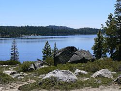
SMUD's electricity generation capacity derives from the watershed of the South Fork of the American River, called the "Upper American River Project (UARP)" in federal licensing documents. The project is an extensive complex of multiple retention dams, diversion dams, reservoirs, canals, tunnels and hydroelectric powerplants. The plants are run during hours of peak demand, though retaining sufficient flood control capacity dictates water releases to some extent.

From upstream to downstream, the District's UARP assets include: [13] [14]

SMUD owns the first of potentially two natural gas power plants (the Cosumnes Power Plant, brought online in 2006 on property adjacent to the decommissioned Rancho Seco nuclear facility) as well as wind-powered and solar-powered electric generation facilities. In addition, the utility owns some small gas-fired peaker plants for meeting the highest energy demands, typically on Sacramento's notably blistering summer days.

SMUD is in the Advisory Council of the PHEV Research Center.

Related Research Articles

<span class="mw-page-title-main">East Bay Municipal Utility District</span>

East Bay Municipal Utility District (EBMUD), colloquially referred to as "East Bay Mud", is a public utility district which provides water and sewage treatment services for an area of approximately 331 square miles (860 km2) in the eastern side of the San Francisco Bay. As of 2018, EBMUD provides drinking water for approximately 1.4 million people in portions of Alameda County and Contra Costa County in California, including the cities of Richmond, El Cerrito, Hercules, San Pablo, Pinole, Lafayette, Moraga, Orinda, Danville, Oakland, Piedmont, Emeryville, Berkeley, Albany, Alameda, San Leandro, neighboring unincorporated regions, and portions of cities such as Hayward and San Ramon. Sewage treatment services are provided for 685,000 people in an 88-square-mile area (as of 2018). EBMUD currently has an average annual growth rate of 0.8% and is projected to serve 1.6 million people by 2030. Headquartered in Oakland, EBMUD owns and maintains 2 water storage reservoirs on the Mokelumne River, 5 terminal reservoirs, 91 miles (146 km) of water transmission aqueducts, 4,100 miles (6,600 km) of water mains, 6 water treatment plants (WTPs), 29 miles (47 km) of wastewater interceptor sewer lines and a regional wastewater treatment facility (WWTF) rated at a maximum treatment capacity of 320 MGD.

<span class="mw-page-title-main">Oroville Dam</span> Dam in California

Oroville Dam is an earthfill embankment dam on the Feather River east of the city of Oroville, California, in the Sierra Nevada foothills east of the Sacramento Valley. At 770 feet (235 m) high, it is the tallest dam in the U.S. and serves mainly for water supply, hydroelectricity generation, and flood control. The dam impounds Lake Oroville, the second-largest reservoir in California, capable of storing more than 3.5 million acre-feet (1.1×10^12 US gal; 4.3×10⁹ m3).

<span class="mw-page-title-main">Mokelumne River</span> River in northern California

The Mokelumne River is a 95-mile (153 km)-long river in northern California in the United States. The river flows west from a rugged portion of the central Sierra Nevada into the Central Valley and ultimately the Sacramento–San Joaquin River Delta, where it empties into the San Joaquin River-Stockton Deepwater Shipping Channel. Together with its main tributary, the Cosumnes River, the Mokelumne drains 2,143 square miles (5,550 km2) in parts of five California counties. Measured to its farthest source at the head of the North Fork, the river stretches for 157 miles (253 km).

<span class="mw-page-title-main">Castaic Dam</span> Embankment dam impounding Castaic Creek in Los Angeles County, California, United States

Castaic Dam is an embankment dam in northwestern Los Angeles County, California, in the unincorporated area of Castaic. Although located on Castaic Creek, a major tributary of the Santa Clara River, Castaic Creek provides little of its water. The lake is the terminus of the West Branch of the California Aqueduct, part of the State Water Project. The dam was built by the California Department of Water Resources and construction was completed in 1973. The lake has a capacity of 325,000 acre-feet (401,000,000 m3) and stores drinking water for the western portion of the Greater Los Angeles Area.

<span class="mw-page-title-main">Rancho Seco Nuclear Generating Station</span>

The Rancho Seco Nuclear Generating Station is a decommissioned nuclear power plant built by the Sacramento Municipal Utility District (SMUD) in Herald, California.

<span class="mw-page-title-main">California State Water Project</span> Flood control, energy production, and water conveyance infrastructure

The California State Water Project, commonly known as the SWP, is a state water management project in the U.S. state of California under the supervision of the California Department of Water Resources. The SWP is one of the largest public water and power utilities in the world, providing drinking water for more than 27 million people and generating an average of 6,500 GWh of hydroelectricity annually. However, as it is the largest single consumer of power in the state itself, it has a net usage of 5,100 GWh.

<span class="mw-page-title-main">Union Valley Reservoir</span> Reservoir in El Dorado County, California

Union Valley Reservoir is a reservoir in eastern El Dorado County, California, about 20 miles (32 km) northeast of Placerville. The 277,000 acre-feet (342,000,000 m3) lake is in Eldorado National Forest in the Sierra Nevada at an elevation of 4,870 feet (1,480 m).

<span class="mw-page-title-main">Loon Lake (California)</span> Reservoir in El Dorado County, California

Loon Lake is a reservoir in the Eldorado National Forest of El Dorado County, California, United States. The 76,200 acre⋅ft (94,000,000 m3) lake is formed by Loon Lake Dam, completed in 1963 as part of the Upper American River Project by Sacramento Municipal Utility District to conserve spring snow melt runoff for use during the summer and autumn for hydroelectric power production. Loon Lake Dam impounds water at the headwaters of Gerle Creek which, prior to the dam, flowed intermittently through (natural) Loon and Pleasant Lakes. But most of the water now stored in Loon Lake arrives from Buck Island Reservoir in the adjacent Rubicon River watershed by way of the Buck-Loon Tunnel. Nearby is Loon Lake Chalet, a popular winter recreation destination. In summer, a boat ramp for water sports and camping are available, but the area is less popular than nearby Union Valley Reservoir and Rubicon Trail.

<span class="mw-page-title-main">Monticello Dam</span> Dam in Napa County, California.

Monticello Dam is a 304-foot (93 m) high concrete arch dam in Napa County, California, United States, constructed between 1953 and 1957. The dam impounded Putah Creek to create Lake Berryessa in the Vaca Mountains.

<span class="mw-page-title-main">Folsom Dam</span> Dam in Folsom, California

Folsom Dam is a concrete gravity dam on the American River of Northern California in the United States, about 25 mi (40 km) northeast of Sacramento. The dam is 340 ft (100 m) high and 1,400 ft (430 m) long, flanked by earthen wing dams. It was completed in 1955, and officially opened the following year.

Simon David Freeman was an American engineer, attorney, and author, who had many key roles in energy policy. After working with the Tennessee Valley Authority, first as an engineer and later as an attorney, he was selected to sit on energy committees by Lyndon Johnson in 1967. He then worked with the United States Environmental Protection Agency, before returning to the TVA as chairman at the request of Jimmy Carter. After finishing his term, Freeman headed several public utilities companies, most notably the New York Power Authority, the Sacramento Municipal Utility District and the Los Angeles Department of Water and Power.

<span class="mw-page-title-main">South Fork American River</span> Tributary of the river in Northern California

The South Fork American River is a major tributary of the American River in El Dorado County, California, draining a watershed on the western slope of the Sierra Nevada east of Sacramento. The river begins in pristine Desolation Wilderness and flows through the Sierra Nevada foothills. The river at Coloma was the site of James Marshall's discovery of gold at Sutter's Mill on January 24, 1848, which started the California Gold Rush. The South Fork of the American is "the most popular recreation stream in the West" for whitewater rafting in North America, e.g., 80,000 visitors in 2011. Professional whitewater rafting companies have been offering commercial rafting trips on the South Fork American River since 1978.

<span class="mw-page-title-main">Los Vaqueros Reservoir</span> Reservoir in Contra Costa County, California

The Los Vaqueros Reservoir and watershed is located in the northern Diablo Range, within northeastern Contra Costa County, northern California. It was completed by the Contra Costa Water District (CCWD) in 1998 to improve the quality of drinking water for its 550,000 customers in Central and Eastern Contra Costa County. The reservoir is accessible via Vasco Road, a road which connects Brentwood and Livermore.

<span class="mw-page-title-main">Mokelumne Aqueduct</span> Bridge

The Mokelumne Aqueduct is a 95-mile (153 km) water conveyance system in central California, United States. The aqueduct is supplied by the Mokelumne River and provides water to 35 municipalities in the East Bay in the San Francisco Bay Area. The aqueduct and the associated dams, pipelines, treatment plants and hydroelectric system are owned and operated by the East Bay Municipal Utility District (EBMUD) and provide over 90 percent of the water used by the agency.

<span class="mw-page-title-main">San Gabriel Dam</span> Dam in Los Angeles County, California

San Gabriel Dam is a rock-fill dam on the San Gabriel River in Los Angeles County, California, within the Angeles National Forest. Completed in 1939, the dam impounds the main stem of the San Gabriel River about 2.5 miles (4.0 km) downstream from the confluence of the river's East and West Forks, which drain a large portion of the San Gabriel Mountains. It is located directly upstream from the Morris Dam. The dam provides flood control, groundwater recharge flows and hydroelectricity for the heavily populated San Gabriel Valley in the Greater Los Angeles metropolitan area.

<span class="mw-page-title-main">Helms Pumped Storage Plant</span> Dam in Fresno County

The Helms Pumped Storage Plant is located 50 mi (80 km) east of Fresno, California in the Sierra Nevada Mountain Range's Sierra National Forest. It is a power station that uses Helms Creek canyon on the North Fork of the Kings River for off-river water storage and the pumped-storage hydroelectric method to generate electricity. After being planned in the early 1970s, construction on the plant began in June 1977 and commercial operations began on 30 June 1984. It has an installed capacity of 1,212 MW and is owned by Pacific Gas and Electric Company.

Slab Creek Dam is a dam in the American River watershed of the central Sierra Nevada, within El Dorado County, California.

<span class="mw-page-title-main">Upper American River Project</span>

The Upper American River Project (UARP) is a hydroelectric system operated by the Sacramento Municipal Utility District (SMUD) of Sacramento, California in the United States.

<span class="mw-page-title-main">Potter Valley Project</span>

The Potter Valley Project is an interbasin water transfer project in Northern California in the United States, delivering water from the Eel River basin to turbines in the headwaters of the Russian River. The project is owned and operated by Pacific Gas and Electric Company (PG&E). The main facilities are two dams on the Eel River, a diversion tunnel and hydroelectric plant. Average annual throughput is 159,000 acre⋅ft (196,000,000 m3), although this figure varies significantly with both the amount of precipitation in the Eel River basin and the demand on the Russian River.

<span class="mw-page-title-main">Upper North Fork Feather River Project</span>

The Upper North Fork Feather River Project is a hydroelectric scheme in the Sierra Nevada of California, within Lassen and Plumas Counties. The project consists of three dams, five power plants, and multiple conduits and tunnels in the headwaters of the North Fork Feather River, a major tributary of the Feather—Sacramento River systems. The total installed capacity is 362.3 megawatts (MW), producing an annual average of 1,171.9 gigawatt hours (GWh). The project is also contracted for the delivery of irrigation water between March 31 and October 31 of each year. The project is owned and operated by Pacific Gas and Electric Company.

References

  1. 1 2 3 "Consolidated Financial Statements Report of Independent Auditors". Sacramento Municipal Utility District. 2019. Retrieved 2022-08-23.
  2. "2018 Annual Report". Sacramento Municipal Utility District. Retrieved 2022-08-23.
  3. "Company information". Sacramento Municipal Utility District. Retrieved 2020-01-11.
  4. "2020 POWER CONTENT LABEL". Sacramento Municipal Utility District. 2020. Retrieved 2022-08-23.
  5. Sacramento Municipal Utility District v. Solano County et al., C023977 (1997).
  6. "PUBLIC UTILITIES CODE SECTION 11501-11509". LegInfo.ca. Archived from the original on 2010-11-06. Retrieved 2022-08-23.
  7. 1 2 1998  Congressional Record, Vol. 144, Page  E13 (January 27, 1998)
  8. Northern California Power Agency v. Federal Power Commission, 514F.2d184 (1975).
  9. 16 U.S.C.   § 824
  10. Boxall, Bettina (2020-02-29). "Westlands Water District gets permanent U.S. contract for massive irrigation deliveries". Los Angeles Times . Archived from the original on 2022-05-19. Retrieved 2020-03-02.
  11. "Bureau of Reclamation Completes First Group of Congressionally-Mandated California Central Valley Project Contract Conversions". Sierra Sun Times. March 2, 2010. Retrieved 2020-03-03.
  12. "Board of Directors". Sacramento Municipal Utility District. Retrieved 2022-08-23.
  13. "Upper American River Project" (PDF). Sacramento Municipal Utility District. Retrieved 2022-08-23.
  14. "Federal Register, Volume 71 Issue 151 (Monday, August 7, 2006". Govinfo.gov. Retrieved 2022-08-23.