| Moccasin Dam | |
|---|---|
| Coordinates | 37°48′41″N120°18′23″W / 37.8113°N 120.3063°W |
| Opening date | 1930 [1] |
| Owner(s) | San Francisco PUC [1] |
| Dam and spillways | |
| Type of dam | Rockfill [1] |
| Impounds | Moccasin Creek [1] |
| Height (foundation) | 60 ft (18 m) [1] |
| Length | 720 ft (220 m) [1] |
| Reservoir | |
| Creates | Moccasin Reservoir |
| Total capacity | 554 acre⋅ft (683,000 m3) [1] |
| Catchment area | 25.4 sq mi (66 km2) [2] |
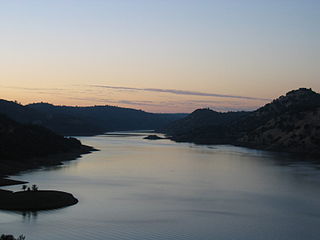
Moccasin Dam is a small dam on Moccasin Creek in Tuolumne County, California, in the town of Moccasin, west of Yosemite. It holds the Moccasin Reservoir. The dam, reservoir and associated hydroelectric power plant are part of the Hetch Hetchy Project, which provide water and power to the city of San Francisco. The dam is located near the junction of Highway 120 and Highway 49.
In 1914 Congress approved the Raker Act, allowing San Francisco to construct a dam and reservoir in the Hetch Hetchy Valley of Yosemite National Park for the purpose of public water supply. Due to the large elevation drop between Hetch Hetchy and the city, several hydroelectric power stations were constructed along the 167-mile (269 km) long Hetch Hetchy aqueduct. [3] Construction of the Moccasin Powerhouse began in 1921 and was completed on August 14, 1925. [4] The Powerhouse was designed by San Francisco Architect Henry A. Minton. The Moccasin Dam was completed in 1930 as a regulating afterbay for the Moccasin Powerhouse.
The Moccasin Creek Fish Hatchery was constructed downstream of the dam in 1954, [5] and raises trout for stocking in high elevation streams in the Tuolumne River watershed, and for the nearby, much larger Lake Don Pedro. [6] In 1969, a new powerhouse with more efficient turbines was constructed to replace the original power plant. [7]
A March 2018 storm caused the Moccasin Reservoir to become overburdened with water and debris. [8] The dam started to leak and evacuations were issued for a small number of houses and a campground downstream before water levels subsided. [8] Although interim repairs are still ongoing, the California Division of Dam Safety allowed the dam to resume normal operations on June 6, 2019. [9]
Moccasin Dam is a rockfill dam, with a structural height of 60 feet (18 m) and a length of 720 feet (220 m), containing 4,815 cubic yards (3,681 m3) of material. [1] The elevation at the dam crest is 929.5 feet (283.3 m) above sea level. [2] The Moccasin Reservoir has a storage capacity of 554 acre-feet (683,000 m3), [1] and a surface area of 29 acres (12 ha). [2] The reservoir has a natural catchment area of 25.4 square miles (66 km2); [2] however, most of its water is imported through the Hetch Hetchy Project pipelines. In order to protect the high-quality Hetch Hetchy water, local flows from Moccasin Creek are captured upstream and routed through a bypass system that discharges downstream of Moccasin Dam. [10] The bypass includes a small hydroelectric plant with a capacity of 2.9 megawatts (MW). [11]
The main Moccasin Powerhouse is situated at the eastern (upstream) end of the reservoir, and consists of two units with a total capacity of 100 megawatts. [7] In 2004, the powerhouse generated 391 million Kilowatt hours (KWh). In 2009, it generated 348 million KWh. [12] Moccasin is the furthest downstream of San Francisco's three hydroelectric plants (the others are Kirkwood, near Hetch Hetchy Reservoir and Holm near Cherry Lake). Operations at all three plants are coordinated from the control room at Moccasin. [7]

Hetch Hetchy is a valley, reservoir, and water system in California in the United States. The glacial Hetch Hetchy Valley lies in the northwestern part of Yosemite National Park and is drained by the Tuolumne River. For thousands of years before the arrival of settlers from the United States in the 1850s, the valley was inhabited by Native Americans who practiced subsistence hunting-gathering.

The Tuolumne River flows for 149 miles (240 km) through Central California, from the high Sierra Nevada to join the San Joaquin River in the Central Valley. Originating at over 8,000 feet (2,400 m) above sea level in Yosemite National Park, the Tuolumne drains a rugged watershed of 1,958 square miles (5,070 km2), carving a series of canyons through the western slope of the Sierra. While the upper Tuolumne is a fast-flowing mountain stream, the lower river crosses a broad, fertile and extensively cultivated alluvial plain. Like most other central California rivers, the Tuolumne is dammed multiple times for irrigation and the generation of hydroelectricity.
The San Francisco Public Utilities Commission (SFPUC) is a public agency of the City and County of San Francisco that provides water, wastewater, and electric power services to the city and an additional 1.9 million customers within three San Francisco Bay Area counties.

New Bullards Bar Dam is a variable radius concrete arch dam constructed in the early 1960s in California on the North Yuba River. Located near the town of Dobbins in Yuba County, the dam forms the New Bullards Bar Reservoir, which can hold about 969,600 acre⋅ft (1.1960×10⁹ m3) of water. The dam serves for irrigation, drinking water and hydroelectric power generation.
Don Pedro Reservoir, also known as Lake Don Pedro, is a reservoir formed by the construction of the New Don Pedro Dam across the Tuolumne River in Tuolumne County, California, United States.
The Raker Act was an act of the United States Congress that permitted building of the O'Shaughnessy Dam and flooding of Hetch Hetchy Valley in Yosemite National Park, California. It is named for John E. Raker, its chief sponsor. The Act, passed by Congress in 1913 during the Wilson administration, specified that because the source of the water and power was on public land, no private profit could be derived from the development. The plan for damming the valley was fought for years by John Muir. Construction of the dam was finished in 1923.

Moccasin, an unincorporated community in Tuolumne County, California, is located at the intersection of State Route 49 and State Route 120. The community is sited on the shore of Moccasin Reservoir at the edge of Lake Don Pedro. The town is home to a State of California Resources Agency, Department of Fish and Game fish hatchery.

Cherry Creek is a large, swift-flowing stream in the Sierra Nevada mountain range, and is the largest tributary of the Tuolumne River. The creek is 44.6 miles (71.8 km) long measured to its farthest headwaters; the main stem itself is 27.7 miles (44.6 km) long, draining a watershed of 234 square miles (610 km2) in the Stanislaus National Forest. Part of the drainage also extends into the northwest corner of Yosemite National Park.

Cherry Lake is an artificial lake in the Stanislaus National Forest of Tuolumne County, California, U.S.A., about 25 miles (40 km) east of the city of Sonora. It is at an elevation of 4,700 feet (1,433 m) on the western side of the Sierra Nevada, and lies just outside the western boundary of Yosemite National Park. The lake has a capacity of 273,500 acre⋅ft (337,400,000 m3) and is formed by Cherry Valley Dam on Cherry Creek.

Lake Eleanor is a reservoir located in the northwestern backcountry of Yosemite National Park at an altitude of 4,657 feet (1,419 m). The reservoir has a capacity of 26,100 acre-feet (32,200,000 m3) and a surface area of 953 acres (3.9 km2).
The Hetch Hetchy Railroad (HHRR) was a 68-mile (109 km) standard gauge Class III railroad constructed by the City of San Francisco to support the construction and expansion of the O'Shaughnessy Dam across Hetch Hetchy Valley.

Lost Creek Lake is a reservoir located on the Rogue River in Jackson County, Oregon, United States. The lake is impounded by William L. Jess Dam which was constructed by the U.S. Army Corps of Engineers in 1977 for flood control and fisheries enhancement. The lake and dam were the first completed elements of the multi-purpose Rogue River Basin Project, consisting of Lost Creek Lake, Applegate Lake and the Elk Creek project. The lake is located approximately 27 miles (43 km) northeast of Medford.

Falls Creek, also known as the Falls River, is a tributary of the Tuolumne River in Yosemite National Park, California, United States. The creek begins at the northern boundary of the national park and flows 24 miles (39 km) to empty into the Tuolumne at Hetch Hetchy Reservoir, dropping over two well-known waterfalls. The Pacific Crest Trail and other national park trails follow the creek for much of its course.

The La Grange Dam is a masonry-gravity diversion dam on the Tuolumne River near La Grange, California. The dam was completed in 1893 by the Turlock Irrigation District and Modesto Irrigation District in an effort to divert water into their canal systems for local farmers.

New Don Pedro Dam, often known simply as Don Pedro Dam, is an earthen embankment dam across the Tuolumne River, about 2 miles (3.2 km) northeast of La Grange, in Tuolumne County, California. The dam was completed in 1971, after four years of construction, to replace the 1924 concrete-arch Don Pedro Dam.

The North Fork Kings River is a 40.3-mile (64.9 km) tributary of the Kings River, in the U.S. state of California. The river's main stem is entirely within Fresno County, and its watershed drains about 387 square miles (1,000 km2) of the southern Sierra Nevada mountain range.
Restore Hetch Hetchy is a US non-profit organization seeking to restore the Hetch Hetchy Valley in Yosemite National Park to its original condition.

The Big Creek Hydroelectric Project is an extensive hydroelectric power scheme on the upper San Joaquin River system, in the Sierra Nevada of central California. The project is owned and operated by Southern California Edison (SCE). The use and reuse of the waters of the San Joaquin River, its South Fork, and the namesake of the project, Big Creek – over a vertical drop of 6,200 ft (1,900 m) – have over the years inspired a nickname, "The Hardest Working Water in the World".
The Modesto Irrigation District (MID) is a special-purpose district that provides irrigation and drinking water, and electrical service, to customers in the San Joaquin Valley within Stanislaus County, California.

O'Shaughnessy Dam is a 430-foot-high (131 m) concrete arch-gravity dam in Tuolumne County, California, United States. It impounds the Tuolumne River, forming the Hetch Hetchy Reservoir at the lower end of Hetch Hetchy Valley in Yosemite National Park, about 160 miles (260 km) east of San Francisco. The dam and reservoir are the source for the Hetch Hetchy Aqueduct, which provides water for over two million people in San Francisco and other municipalities of the west Bay Area. The dam is named for engineer Michael O'Shaughnessy, who oversaw its construction.