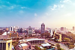
Upper Hill is a central business district of the city of Nairobi, the capital and largest city of Kenya. The district has seen an increase in major construction in recent years,[when?] with several multinational corporations setting up offices.[1][2]
Upper Hill was historically one of the residential neighbourhoods of the city of Nairobi, during colonial times, and stretched all the way to the Kilimani estate. The 280 hectares (700 acres) that comprise part of Upper Hill were majorly owned by Kenya Railways.[4] During the 1990s and early 2000s, as land and office space became scarce and exorbitantly priced in the central business district, businesses relocated to Upper Hill and Westlands, where land and office space were more readily available and less expensive. Today, Upper Hill possesses a new modern skyline that is still being filled by modern skyscrapers of different and prestigious designs in the architectural world.[5][6][7]
Economy
This section needs expansion. You can help by adding to it. (April 2020)
↑"Contact". Spencon. 24 May 2011. Archived from the original on 24 May 2011. Retrieved 6 April 2020. Rahimtulla Tower, hill road P.O. Box 881-00606 Nairobi Kenya
This page is based on this Wikipedia article Text is available under the CC BY-SA 4.0 license; additional terms may apply. Images, videos and audio are available under their respective licenses.