
Marina Alta is a central and coastal comarca of the autonomous community of Valencia, Spain. The comarca is located in the area of Alicante and its capital and largest settlement is the city of Dénia.
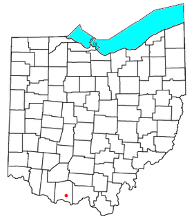
Lynx is an unincorporated community in southwestern Brush Creek Township, Adams County, Ohio, United States. Although it is unincorporated, it has a post office, with the ZIP code of 45650. It is located along State Route 125.

Semera or Samera is a new town on the Awash–Asseb highway in north-east Ethiopia, planned to replace Asaita as the capital of the Afar Region. Located in the Administrative Zone 1, Semera has a latitude and longitude of 11°47′32″N41°0′31″E. One of the completed buildings is Samara University Health science College, which began holding classes in 2007.
Muzeum Piernika is a museum located in medieval old town of Toruń, Poland, that is famous for its gingerbread. Visitors take part in an interactive show through which they are taught how to make a traditional gingerbread. The show consist of two parts - first visitors are shown how the dough was made in Middle Ages. Having prepared dough, everyone then makes their own gingerbread using traditional baking molds. Throughout the whole show visitors are guided by the master of bakery, a gingerbread witch and the craftsmen.
Kituryki is a village in the administrative district of Gmina Michałowo, within Białystok County, Podlaskie Voivodeship, in north-eastern Poland, close to the border with Belarus.

Tolów is a village in the administrative district of Gmina Świnice Warckie, within Łęczyca County, Łódź Voivodeship, in central Poland. It lies approximately 4 kilometres (2 mi) south-west of Świnice Warckie, 22 km (14 mi) west of Łęczyca, and 47 km (29 mi) north-west of the regional capital Łódź.
Humięcino-Klary is a village in the administrative district of Gmina Grudusk, within Ciechanów County, Masovian Voivodeship, in east-central Poland.
Smolno Wielkie is a village in the administrative district of Gmina Kargowa, within Zielona Góra County, Lubusz Voivodeship, in western Poland.
Bagna is a settlement in the administrative district of Gmina Czersk, within Chojnice County, Pomeranian Voivodeship, in northern Poland.
Płęsy is a village in the administrative district of Gmina Dziemiany, within Kościerzyna County, Pomeranian Voivodeship, in northern Poland. It lies approximately 9 kilometres (6 mi) east of Dziemiany, 14 km (9 mi) south-west of Kościerzyna, and 63 km (39 mi) south-west of the regional capital Gdańsk.
Kościerska Huta is a village in the administrative district of Gmina Kościerzyna, within Kościerzyna County, Pomeranian Voivodeship, in northern Poland. It lies approximately 3 kilometres (2 mi) north-east of Kościerzyna and 49 km (30 mi) south-west of the regional capital Gdańsk.
Brzyno is a village in the administrative district of Gmina Krokowa, within Puck County, Pomeranian Voivodeship, in northern Poland. It lies approximately 10 kilometres (6 mi) west of Krokowa, 27 km (17 mi) west of Puck, and 61 km (38 mi) north-west of the regional capital Gdańsk.
Prusewo is a village in the administrative district of Gmina Krokowa, within Puck County, Pomeranian Voivodeship, in northern Poland. It lies approximately 12 kilometres (7 mi) west of Krokowa, 28 km (17 mi) west of Puck, and 62 km (39 mi) north-west of the regional capital Gdańsk.
Lug is a settlement in the region of Baranja, Croatia. Administratively, it is located in the Bilje municipality within the Osijek-Baranja County. Population is 852 people.
Nowe Guty is a village in the administrative district of Gmina Orzysz, within Pisz County, Warmian-Masurian Voivodeship, in northern Poland. It lies approximately 8 kilometres (5 mi) south-west of Orzysz, 18 km (11 mi) north of Pisz, and 90 km (56 mi) east of the regional capital Olsztyn.

Comarques Centrals is one of the seven territories defined by the Regional Plan of Catalonia. It is located in the central part of Catalonia and will be formed by five comarques: Anoia, Bages, Berguedà, Osona and Solsonès.
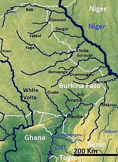
The Sirba River is a tributary of the Niger River in western Africa. The Sirba arises in Burkina Faso and flows east, crosses into Niger and then forms a short part of the international border between the two countries. It meets the Niger River at the midway point between the settlements of Gothèye and Karma in Niger, about 50 kilometres upstream from Niamey.
Juan N. Méndez Municipality is a municipality in Puebla in south-eastern Mexico.

Podromanija is a village in the municipality of Sokolac, Republika Srpska, Bosnia and Herzegovina.


