
Hampshire County is a county in the U.S. state of West Virginia. As of the 2010 census, the population was 23,964. Its county seat is Romney, West Virginia's oldest town (1762). The county was created by the Virginia General Assembly in 1754, from parts of Frederick and Augusta Counties (Virginia) and is the state's oldest county. The county lies in both West Virginia's Eastern Panhandle and Potomac Highlands regions.

The Monongahela River —often referred to locally as the Mon —is a 130-mile-long (210 km) river on the Allegheny Plateau in north-central West Virginia and southwestern Pennsylvania. The river flows from the confluence of its west and east forks in north-central West Virginia northeasterly into southwestern Pennsylvania, then northerly to Pittsburgh and its confluence with the Allegheny River to form the Ohio River. The river's entire length is navigable via a series of locks and dams.

The Western Maryland Railway was an American Class I railroad (1852–1983) which operated in Maryland, West Virginia, and Pennsylvania. It was primarily a coal hauling and freight railroad, with a small passenger train operation.

The South Branch Potomac River has its headwaters in northwestern Highland County, Virginia near Hightown along the eastern edge of the Allegheny Front. After a river distance of 139 miles (224 km), the mouth of the South Branch lies east of Green Spring in Hampshire County, West Virginia where it meets the North Branch Potomac River to form the Potomac.

Cass Scenic Railroad State Park is a state park and heritage railroad located in Cass, Pocahontas County, West Virginia.
Hooks Mills is an unincorporated community in Hampshire County, West Virginia, United States. It is located on Hooks Mill Road which intersects Cacapon River Road 4.5 miles south of Capon Bridge. Hooks Mills is named for the saw and grist mill on the Cacapon River run by the Hook family from 1848 to the late 1930s.
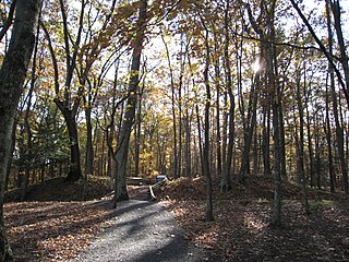
The Fort Mill Ridge Wildlife Management Area is located on 217 acres (0.88 km2) two miles (3 km) southwest of Romney in Hampshire County, West Virginia. Fort Mill Ridge WMA is owned by the West Virginia Division of Natural Resources. The Fort Mill Ridge Civil War Trenches are located at the top of the Fort Mill Ridge access road.

Mill Creek Mountain is a continuous mountain ridge that runs northeast through Hampshire and Hardy counties in the Eastern Panhandle region of the U.S. state of West Virginia. Rising to its greatest elevation of 2,650 feet (808 m) at High Knob, Mill Creek is a folded mountain ridge, belonging to the Ridge-and-Valley Appalachians. Mill Creek Mountain forms the western edge of the South Branch Potomac River Valley and is named for Mill Creek that carves through it at Mechanicsburg Gap allowing the Northwestern Turnpike to pass through as well. Along with Sawmill Ridge, Mill Creek Mountain forms the Trough along the South Branch.

Mill Creek is a 14.0-mile-long (22.5 km) tributary stream of the South Branch Potomac River, belonging to the Potomac River and Chesapeake Bay watersheds. The stream is located in Hampshire County in West Virginia's Eastern Panhandle. Mill Creek flows into the South Branch west of Romney Bridge near Vanderlip along the Northwestern Turnpike.

Great North Mountain is a 50-mile (80 km) long mountain ridge within the Ridge-and-valley Appalachians in the U.S. states of Virginia and West Virginia. The ridge is located west of the Shenandoah Valley and Massanutten Mountain in Virginia, and east of the Allegheny Mountains and Cacapon River in West Virginia.
Mill Creek is a 5.3-mile-long (8.5 km) tributary stream of the North Fork South Branch Potomac River in Pendleton County, West Virginia. Mill Creek rises on the western flanks of North Fork Mountain and from there, flows north through Germany Valley. Its confluence with the North Fork lies at Hinkle Gap between Germany and Harman Knobs.
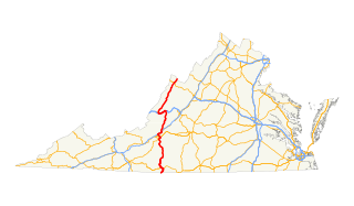
In the U.S. state of Virginia, U.S. Route 220 (US 220) is a major north-south state highway that extends from the North Carolina state line through Roanoke to the West Virginia state line. South of Roanoke, US 220 is a four-lane highway within the proposed Interstate 73 (I-73) corridor. US 220 narrows to two lanes north of Roanoke, connecting to I-64 near Clifton Forge and then paralleling the Appalachian Mountains north-northeasterly in the direction of Cumberland, Maryland.

State Route 84 is a primary state highway in the U.S. state of Virginia. Known as Mill Gap Road, the state highway runs 14.94 miles (24.04 km) from the West Virginia state line near Mill Gap, where the highway continues west as West Virginia Route 84, east to U.S. Route 220 at Vanderpool.

The Great Indian Warpath (GIW)—also known as the Great Indian War and Trading Path, or the Seneca Trail—was that part of the network of trails in eastern North America developed and used by Native Americans which ran through the Great Appalachian Valley. The system of footpaths extended from what is now upper New York to deep within Alabama. Various Indians traded and made war along the trails, including the Catawba, numerous Algonquian tribes, the Cherokee, and the Iroquois Confederacy. The British traders' name for the route was derived from combining its name among the northeastern Algonquian tribes, Mishimayagat or "Great Trail", with that of the Shawnee and Delaware, Athawominee or "Path where they go armed".

Germany Valley is a scenic upland valley high in the Allegheny Mountains of eastern West Virginia originally settled by German farmers in the mid-18th century. It is today a part of the Spruce Knob-Seneca Rocks National Recreation Area of the Monongahela National Forest, although much ownership of the Valley remains in private hands.
Valley Bend is a census-designated place (CDP) in Randolph County, West Virginia, United States. Valley Bend is located on U.S. routes 219 and 250, as well as state routes 55 and 92, 3.5 miles (5.6 km) northwest of Mill Creek. Valley Bend has a post office with ZIP code 26293. As of the 2010 census, its population was 485.
Virginia State Route 102 and West Virginia Route 102 are adjoining state highways in the U.S. states of Virginia and West Virginia. The two state highways together run 11.4 miles (18.3 km) from Center Street in Pocahontas, Virginia east to the Virginia – West Virginia state line between the twin cities of Bluefield, Virginia and Bluefield, West Virginia. Most of Route 102 consists of three sections in Virginia maintained by the Virginia Department of Transportation (VDOT); the two intervening sections in West Virginia are maintained by the West Virginia Division of Highways. In addition to connecting Pocahontas with the two Bluefields, the state highway passes through Nemours, West Virginia and Falls Mills, Virginia and provides access to Bluefield College.

Ripley District, formerly Ripley Magisterial District, is one of five historic magisterial districts in Jackson County, West Virginia, United States. The district was originally known as Mill Creek Township, one of five civil townships established in Jackson County after West Virginia became a state in 1863; it was renamed "Ripley Township" after its chief town in 1871, and the following year, all of West Virginia's townships were converted into magisterial districts. When Jackson County was redistricted in the 1990s, the area of Ripley District was divided between the new Eastern and Western Magisterial Districts. However, the county's historic magisterial districts continue to exist in the form of tax districts, serving all of their former administrative functions except for the election of county officials.

The Western Magisterial District is one of three magisterial districts in Jackson County, West Virginia, United States. It was established during a process of redistricting undertaken in the 1990s. In 2010, 10,576 people lived in the district.


