Veguitas, Jayuya, Puerto Rico

Last updated
Veguitas
Barrio
Hacienda Gripinas - panoramio.jpg
Hacienda Gripiñas in Vequitas
Veguitas, Jayuya, Puerto Rico locator map.png
Location of Veguitas within the municipality of Jayuya shown in red
Caribbean location map.svg
Red pog.svg
Veguitas
Location of Puerto Rico
Coordinates: 18°11′45″N66°35′14″W / 18.195904°N 66.587283°W / 18.195904; -66.587283 [1]
Commonwealth Flag of Puerto Rico.svg  Puerto Rico
Municipality Flag of Jayuya.svg Jayuya
Area
[1]
  Total6.63 sq mi (17.2 km2)
  Land6.63 sq mi (17.2 km2)
  Water0.00 sq mi (0.0 km2)
Elevation
[2]
2,139 ft (652 m)
Population
 (2010)
  Total3,685
  Density555.8/sq mi (214.6/km2)
 Source: 2010 Census
Time zone UTC−4 (AST)

Veguitas is a barrio in the municipality of Jayuya, Puerto Rico. Its population in 2010 was 3,685. [3] [4] [5]

Contents

Historical population
CensusPop.Note
1950 2,570
1960 2,202−14.3%
1980 3,345
1990 3,78213.1%
2000 3,9644.8%
2010 3,685−7.0%
U.S. Decennial Census
1900 (N/A) [6] 1910-1930 [7]
1930-1950 [8] 1980-2000 [9] 2010 [10]

See also

Related Research Articles

<span class="mw-page-title-main">Monacillo Urbano, San Juan, Puerto Rico</span> Barrio of San Juan, Puerto Rico

Monacillo Urbano is one of 18 barrios in the municipality of San Juan, Puerto Rico. The barrio was originally part of Monacillo. In 2010, it had a population of 22,342 living in a land area of 3.23 square miles (8.68 km2). Monacillo Urbano is surrounded by Gobernador Piñero barrio to the north, El Cinco barrio to the east, Monacillo barrio to the south, and the municipality of Guaynabo to the west.

<span class="mw-page-title-main">Oriente, San Juan, Puerto Rico</span> Barrio of Puerto Rico

Oriente is one of the 18 barrios of the municipality of San Juan, Puerto Rico. It is composed of 3 subbarrios: Borinquen, López Sicardó, and San José. Before 1951, it was a barrio of the former municipality of Rio Piedras. In 2010, it had a population of 31,374. It is surrounded by the barrios of Sabana Llana Norte to the east, Sabana Llana Sur to the south, Hato Rey Central and Hato Rey Norte to the west, and Santurce barrio and the San Jose Lagoon to the north.

<span class="mw-page-title-main">Dajaos, Bayamón, Puerto Rico</span> Barrio of Puerto Rico

Dajaos is a barrio in the municipality of Bayamón, Puerto Rico. Its population in 2010 was 2,831.

<span class="mw-page-title-main">Pájaros, Bayamón, Puerto Rico</span> Barrio of Puerto Rico

Pájaros is a barrio in the municipality of Bayamón, Puerto Rico. Its population in 2010 was 30,194.

<span class="mw-page-title-main">Río Grande, Jayuya, Puerto Rico</span> Barrio of Puerto Rico

Río Grande is a barrio in the municipality of Jayuya, Puerto Rico. Its population in 2010 was 879.

<span class="mw-page-title-main">Quebrada Grande, Mayagüez, Puerto Rico</span> Barrio of Puerto Rico

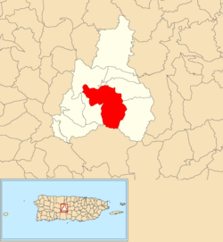
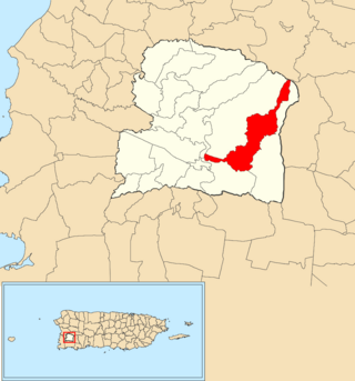
Quebrada Grande is a barrio in the municipality of Mayagüez, Puerto Rico. Its population in 2010 was 5,558.

<span class="mw-page-title-main">Mata de Plátano</span> Barrio of Luquillo, Puerto Rico

Mata de Plátano is a barrio in the municipality of Luquillo, Puerto Rico. Its population in 2010 was 8,972.

<span class="mw-page-title-main">Mayagüez Arriba</span> Barrio of Mayagüez, Puerto Rico

Mayagüez Arriba is a barrio in the municipality of Mayagüez, Puerto Rico. Its population in 2010 was 5,341.

<span class="mw-page-title-main">Rufina, Guayanilla, Puerto Rico</span> Barrio of Puerto Rico

Rufina is a rural barrio in the municipality of Guayanilla, Puerto Rico. Its population in 2010 was 220. Rufina was established in 1935 and was made up of parts of Guayanilla barrio-pueblo and Indios barrio in Guayanilla.

<span class="mw-page-title-main">Campo Alegre, Hatillo, Puerto Rico</span> Barrio of Puerto Rico

Campo Alegre is a rural barrio in the municipality of Hatillo, Puerto Rico. Its population in 2010 was 5,210.

<span class="mw-page-title-main">Lirios</span> Barrio of Juncos, Puerto Rico

Lirios is a barrio in the municipality of Juncos, Puerto Rico. Its population in 2010 was 5,646.

<span class="mw-page-title-main">Plata, Lajas, Puerto Rico</span> Barrio of Puerto Rico

Plata is a barrio in the municipality of Lajas, Puerto Rico. Its population in 2010 was 2,620.

<span class="mw-page-title-main">Jobos, Guayama, Puerto Rico</span> Barrio of Puerto Rico

Jobos is a barrio in the municipality of Guayama, Puerto Rico. Its population in 2010 was 8,286.

<span class="mw-page-title-main">Guerrero, Isabela, Puerto Rico</span> Barrio of Puerto Rico

Guerrero is a barrio in the municipality of Isabela, Puerto Rico. Its population in 2010 was 3,552.

<span class="mw-page-title-main">Cedro, Guayanilla, Puerto Rico</span> Barrio of Puerto Rico

Cedro is an uninhabited rural barrio in the municipality of Guayanilla, Puerto Rico. Its population in 2010 was 0.

<span class="mw-page-title-main">Guamaní</span> Barrio of Guayama, Puerto Rico

Guamaní is a barrio in the municipality of Guayama, Puerto Rico. Its population in 2010 was 1,455.

<span class="mw-page-title-main">París, Lajas, Puerto Rico</span> Barrio of Puerto Rico

París is a barrio in the municipality of Lajas, Puerto Rico. Its population in 2010 was 968.

<span class="mw-page-title-main">Guamá, San Germán, Puerto Rico</span> Barrio of Puerto Rico

Guamá is a barrio in the municipality of San Germán, Puerto Rico. Its population in 2010 was 2,126.

<span class="mw-page-title-main">San Salvador, Caguas, Puerto Rico</span> Barrio of Puerto Rico

San Salvador is a barrio in the municipality of Caguas, Puerto Rico. Its population in 2010 was 3,089.

<span class="mw-page-title-main">Tijeras, Juana Díaz, Puerto Rico</span> Barrio of Puerto Rico

Tijeras is a barrio in the municipality of Juana Díaz, Puerto Rico. Its population in 2010 was 5,670.

References

  1. 1 2 "US Gazetteer 2019". US Census. US Government.
  2. U.S. Geological Survey Geographic Names Information System: Veguitas Barrio
  3. Picó, Rafael; Buitrago de Santiago, Zayda; Berrios, Hector H. Nueva geografía de Puerto Rico: física, económica, y social, por Rafael Picó. Con la colaboración de Zayda Buitrago de Santiago y Héctor H. Berrios. San Juan Editorial Universitaria, Universidad de Puerto Rico,1969.
  4. Gwillim Law (20 May 2015). Administrative Subdivisions of Countries: A Comprehensive World Reference, 1900 through 1998. McFarland. p. 300. ISBN   978-1-4766-0447-3 . Retrieved 25 December 2018.
  5. Puerto Rico: 2010 Population and Housing Unit Counts.pdf (PDF). U.S. Dept. of Commerce, Economics and Statistics Administration, U.S. Census Bureau. 2010.
  6. "Report of the Census of Porto Rico 1899". War Department Office Director Census of Porto Rico. Archived from the original on July 16, 2017. Retrieved September 21, 2017.
  7. "Table 3-Population of Municipalities: 1930 1920 and 1910" (PDF). United States Census Bureau. Archived (PDF) from the original on August 17, 2017. Retrieved September 21, 2017.
  8. "Table 4-Area and Population of Municipalities Urban and Rural: 1930 to 1950" (PDF). United States Census Bureau. Archived (PDF) from the original on August 30, 2015. Retrieved September 21, 2014.
  9. "Table 2 Population and Housing Units: 1960 to 2000" (PDF). United States Census Bureau. Archived (PDF) from the original on July 24, 2017. Retrieved September 21, 2017.
  10. Puerto Rico: 2010 Population and Housing Unit Counts.pdf (PDF). U.S. Dept. of Commerce Economics and Statistics Administration U.S. Census Bureau. 2010. Archived (PDF) from the original on 2017-02-20. Retrieved 2019-08-02.