Velden (Vils)

Last updated
Velden
Ortsansicht von Velden 02.jpg
Velden seen from the west
DEU Velden (Vils) COA.svg
Location of Velden within Landshut district
Velden in LA.svgAhamAltdorfBruckbergEchingFurthNeufahrnTiefenbachVeldenWeng
Germany adm location map.svg
Red pog.svg
Velden
Bavaria location map.svg
Red pog.svg
Velden
Coordinates: 48°22′N12°15′E / 48.367°N 12.250°E / 48.367; 12.250
Country Germany
State Bavaria
Admin. region Niederbayern
District Landshut
Municipal assoc. Velden (Vils)
Government
   Mayor (202026) Ludwig Greimel [1] (FW)
Area
  Total
49.40 km2 (19.07 sq mi)
Elevation
477 m (1,565 ft)
Population
 (2023-12-31) [2]
  Total
6,617
  Density130/km2 (350/sq mi)
Time zone UTC+01:00 (CET)
  Summer (DST) UTC+02:00 (CEST)
Postal codes
84149
Dialling codes 08742
Vehicle registration LA
Website https://www.markt-velden.de/

Velden is a market town and municipality in the district of Landshut in Bavaria in Germany.

Contents

Geography

Velden lies on the border from Lower Bavaria to Upper Bavaria. The river Vils runs through the town. Velden is about 64 kilometers northeast of Munich.

The municipality consists of 130 villages and communes [3]

  • Aichelsberg
  • Aign
  • Alteberspoint
  • Asching
  • Asenreit
  • Atzmannsdorf
  • Babing
  • Bach
  • Bachmühle
  • Baueröd
  • Biedenbach
  • Biedersdorf
  • Birnkam
  • Brandstätt
  • Bruck
  • Burg
  • Burghab
  • Eberlsöd
  • Eberspoint
  • Eggersgrub
  • Eglso
  • Eichten
  • Einäuglmühle
  • Elling
  • Erlach
  • Erzmannsdorf
  • Exenberg
  • Feuchten
  • Fischbach
  • Forsthof
  • Futteröd
  • Futtersöd
  • Geratsfurth
  • Giglberg I
  • Giglberg II
  • Glocksberg
  • Grünzing
  • Gumpersberg
  • Guntersberg
  • Hackelsberg
  • Hackenkam
  • Haid
  • Haideck
  • Haldenweber
  • Haselbach
  • Heinhub
  • Herrneck
  • Hintelsberg
  • Hinterkobl
  • Hinteröd
  • Hirschhof
  • Hofbruck
  • Höhenberg
  • Holzen I
  • Holzen II
  • Holzhäuseln
  • Hub
  • Irreck
  • Irrthal
  • Kleinhaid
  • Kleinvelden
  • Koralden
  • Kothlehen
  • Kremshub
  • Kreuz
  • Kronwinkel
  • Kühloh
  • Lahn
  • Lehen
  • Leiten
  • Lug
  • Maierhof
  • Maiersdorf
  • Mariaberg
  • Marsberg
  • Martinsberg
  • Miethal
  • Mitterschweibach
  • Mölling
  • Moosing
  • Nehaid
  • Neunehaid
  • Oberbabing
  • Oberensbach
  • Oberschweibach
  • Obervilslern
  • Ofen
  • Paulusberg
  • Pfenningsöd
  • Pretzkobl
  • Putzenberg
  • Raffelberg
  • Rimberg
  • Ringofen
  • Rothenwald
  • Rothweg
  • Rundthal
  • Ruprechtsberg
  • Sattelstatt
  • Schafhausen
  • Schapfthal
  • Schlegelsreit
  • Schmidten
  • Schmitten
  • Schöllamühle
  • Schurfsöd
  • Schwarzeck
  • Schwarzmoos
  • See
  • Seidlthal
  • Spindlhäusl
  • Spitzlbach
  • Stietenöd
  • Stockham
  • Straß
  • Strohhof
  • Unterensbach
  • Unterschweibach
  • Untervilslern
  • Velden
  • Viehweide
  • Vils
  • Vilssöhl
  • Wagensberg
  • Walding
  • Walln
  • Weiher
  • Wildberg
  • Willgrub
  • Zweifurth

History

The first mentioning of a Place named Feldin is found in 773. In 788 King Charles the Great displaced the bavarian Duke Tassilo III and made it a part of Francia. Later it became a Municipality with Market town status, but it is not sure when this happened as there does not exist a certificate of appointment. The first time the market status is mentioned was in a writ in 1394.

Transport

Velden once had a railway connection to Dorfen via Taufkirchen. In 1994 the tracks were removed and converted to a now very popular cycle track. Velden lies on the Bundesstraße B 388. Frequent buses connect Velden to Vilsbiburg, Landshut and Dorfen. The nearest airport is Munich International Airport about 40 km to the southwest.

Architecture & Art

In the center of Velden is St. Peter's church. It was built in two steps around 1450, newly renovated around 1990. Its 64m high tower is a main sight of Velden.

Velden also features an open-air museum with many sculptures of Georg Brenninger (born in Velden - later worked in Munich) for example the "Apoll" or the "Bergpredigt", also two fountains by the same sculptor can be seen in the center of the town.

In 1985 Bavarian Television filmed parts of the TV-Series Irgendwie und Sowieso in and around Velden. (Actors Ottfried Fischer, Elmar Wepper, Bruno Jonas and others)

Notable people

Sister cities

Related Research Articles

<span class="mw-page-title-main">Zwiesel</span> Town in Bavaria, Germany

Zwiesel is a town in the lower-Bavarian district of Regen, and since 1972 is a Luftkurort with particularly good air. The name of the town was derived from the Bavarian word stem zwisl which refers to the form of a fork. The fork of the rivers Großer Regen and Kleiner Regen and the land that lies between these two rivers were called Zwiesel.

<span class="mw-page-title-main">Ismaning</span> Municipality in Bavaria, Germany

Ismaning is a municipality in Bavaria, Germany, located near Munich.

<span class="mw-page-title-main">Erding</span> Town in Bavaria, Germany

Erding is a town in Bavaria, Germany, and capital of the rural district of the same name. It had a population of 36,469 in 2019.

<span class="mw-page-title-main">Moosburg an der Isar</span> Town in Bavaria, Germany

Moosburg an der Isar is a town in the Landkreis Freising of Bavaria, Germany.

<span class="mw-page-title-main">Eichendorf</span> Municipality in Bavaria, Germany

Eichendorf(Bavarian: Oachadoaf) is a municipality in the district of Dingolfing-Landau in Bavaria in Germany.

<span class="mw-page-title-main">Dorfen</span> River in Germany

Dorfen is a town in the district of Erding, in Bavaria, Germany. It is situated 50 km east of Munich and 29 km south of Landshut.

<span class="mw-page-title-main">Vilsbiburg</span> Town in Bavaria, Germany

Vilsbiburg is a town on the river Große Vils, 18 km southeast of Landshut, in the district of Landshut, in Bavaria, Germany. The city owes its name to the river Große Vils which runs through Vilsbiburg. As of 2019 Vilsbiburg has 12,203 inhabitants.

<span class="mw-page-title-main">Abenberg</span> Town in Bavaria, Germany

Abenberg is a town in the Middle Franconian district of Roth, in Bavaria, Germany. It is situated 9 km west of Roth bei Nürnberg and 25 km southwest of Nuremberg.

<span class="mw-page-title-main">Geisenhausen</span> Municipality in Bavaria, Germany

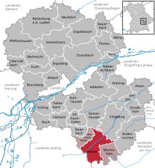
Geisenhausen is a municipality with market town status in the district of Landshut, in Bavaria, Germany. It is situated 14 km southeast of Landshut in the valley of the Kleine Vils.

<span class="mw-page-title-main">Schmidmühlen</span> Municipality in Bavaria, Germany

Schmidmühlen is a municipality in the district of Amberg-Sulzbach in Bavaria in Germany. It is situated at the junction of the Vils and Lauterach rivers.

<span class="mw-page-title-main">Pretzfeld</span> Municipality in Bavaria, Germany

Pretzfeld is a municipality in the district of Forchheim in Bavaria in Germany.

<span class="mw-page-title-main">Langenbach, Bavaria</span> Municipality in Bavaria, Germany

Langenbach is a municipality in the district of Freising in Bavaria in Germany.

<span class="mw-page-title-main">Oberau</span> Municipality in Bavaria, Germany

Oberau is a municipality in the district of Garmisch-Partenkirchen, in Bavaria, Germany.

<span class="mw-page-title-main">Aiglsbach</span> Municipality in Bavaria, Germany

Aiglsbach is a town and municipality in the Lower Bavarian district of Kelheim, Germany, and a member of the Mainburg administrative partnership, a voluntary resource-pooling agreement with three neighbouring municipalities.

<span class="mw-page-title-main">Adlkofen</span> Municipality in Bavaria, Germany

Adlkofen is a municipality in the South Bavarian district of Landshut.

<span class="mw-page-title-main">Bayerbach bei Ergoldsbach</span> Municipality in Bavaria, Germany

Bayerbach is a municipality in the district of Landshut in Bavaria in Germany.

<span class="mw-page-title-main">Buchbach</span> Municipality in Bavaria, Germany

Buchbach is a municipality in the district of Mühldorf in Bavaria in Germany.

<span class="mw-page-title-main">Haag in Oberbayern</span> Municipality in Bavaria, Germany

Haag in Oberbayern is a municipality in the district of Mühldorf in Bavaria in Germany, in December 2013 the municipality had a population of 6359.

<span class="mw-page-title-main">Bad Griesbach</span> Town in Bavaria, Germany

Bad Griesbach im Rottal, or just Bad Griesbach, is a town in the district of Passau in Bavaria in Germany.

<span class="mw-page-title-main">Ortenburg, Bavaria</span> Municipality in Bavaria, Germany

Ortenburg is a municipality and old market town in the district of Passau in Bavaria in Germany.

References

  1. Liste der ersten Bürgermeister/Oberbürgermeister in kreisangehörigen Gemeinden, Bayerisches Landesamt für Statistik, 15 July 2021.
  2. Genesis Online-Datenbank des Bayerischen Landesamtes für Statistik Tabelle 12411-003r Fortschreibung des Bevölkerungsstandes: Gemeinden, Stichtag (Einwohnerzahlen auf Grundlage des Zensus 2011).
  3. "Bayerische Landesbibliothek Online (BLO)". Bayerische-landesbibliothek-online.de. Retrieved 2012-05-23.