Verona Township was organized in 1858, and named after Verona, in Italy.[3]
Geography
According to the United States Census Bureau, the township has a total area of 35.5square miles (91.9km2), of which 35.5squaremiles (91.8km2) is land and 0.03% is water.
Demographics
As of the census[1] of 2000, there were 391 people, 158 households, and 118 families residing in the township. The population density was 11.0 people per square mile (4.3/km2). There were 168 housing units at an average density of 4.7/sqmi (1.8/km2). The racial makeup of the township was 99.74% White, and 0.26% from two or more races. Hispanic or Latino of any race were 0.26% of the population.
There were 158 households, out of which 25.9% had children under the age of 18 living with them, 69.6% were married couples living together, 3.2% had a female householder with no husband present, and 24.7% were non-families. 22.8% of all households Verona Township is a township in Faribault County, Minnesota, United States. The population was 391 at the 2000 census.
Verona Township was organized in 1858, and named after Verona, in Italy.
Geography[edit]
According to the United States Census Bureau, the township has a total area of 35.5 square miles (91.9km2), of which 35.5 square miles (91.8km2) is land and 0.03% is water.
Demographics[edit]
As of the census of 2000, there were 391 people, 158 households, and 118 families residing in the township. The population density was 11.0 inhabitants per square mile (4.2/km2). There were 168 housing units at an average density of 4.7/sq mi (1.8/km2). The racial makeup of the township was 99.74% White, and 0.26% from two or more races. Hispanic or Latino of any race were 0.26% of the population.
There were 158 households, out of which 25.9% had children under the age of 18 living with them, 69.6% were married couples living together, 3.2% had a female householder with no husband present, and 24.7% were non-families. 22.8% of all households comprised individuals, and 11.4% had someone living alone who was 65 years of age or older. The average household size was 2.47 and the average family size was 2.86.
In the township the population was spread out, with 23.0% under the age of 18, 8.2% from 18 to 24, 20.5% from 25 to 44, 30.2% from 45 to 64, and 18.2% who were 65 years of age or older. The median age was 44 years. For every 100 females, there were 97.5 males. For every 100 females age 18 and over, there were 102.0 males.
The median income for a household in the township was $42,750, and the median income for a family was $53,333. Males had a median income of $27,188 versus $17,000 for females. The per capita income for the township was $19,690. About 6.7% of families and 12.6% of the population were below the poverty line, including 24.0% of those under age 18 and 8.3% of those age 65 or over.
Related Research Articles
Thornapple Township is a civil township of Barry County in the U.S. state of Michigan. The population was 9,331 at the 2020 census. It is the most populous township in Barry County.
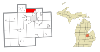
Verona Township is a civil township of Huron County in the U.S. state of Michigan. The population was 1,210 at the 2020 census.
Kochville Township is a general law township of Saginaw County in the U.S. state of Michigan. The population was 4,911 at the 2020 census. It is the home of Saginaw Valley State University.
Randolph is a city in Dakota County, Minnesota, United States. The population was 436 at the 2010 census.
Steamboat River Township is a township in Hubbard County, Minnesota, United States. The population was 123 at the 2000 census.
Derrynane Township is a township in Le Sueur County, Minnesota, United States. The population was 549 at the 2000 census.
Greenbush Township is a township in Mille Lacs County, Minnesota, United States. The population was 1,293 at the 2010 census.
Aastad Township is a township in Otter Tail County, Minnesota, United States. The population was 187 at the 2000 census.
Amor Township is a township in Otter Tail County, Minnesota, United States. The population was 558 at the 2020 census.
Aurdal Township is a township in Otter Tail County, Minnesota, United States. The population was 1,362 at the 2000 census.
Buse Township is a township in Otter Tail County, Minnesota, United States. The population was 690 at the 2000 census.
Osborne Township is a township in Pipestone County, Minnesota, United States. The population was 324 at the 2000 census.
Angus Township is a township in Polk County, Minnesota, United States. It is part of the Grand Forks-ND-MN Metropolitan Statistical Area. The population was 112 at the 2000 census.
Garfield Township is a township in Polk County, Minnesota, United States. It is part of the Grand Forks-ND-MN Metropolitan Statistical Area. The population was 391 at the 2000 census.
Grand Forks Township is a township in Polk County, Minnesota, United States. It is part of the Grand Forks-ND-MN Metropolitan Statistical Area. The population was 231 at the 2000 census.
Echo Township is a township in Yellow Medicine County, Minnesota, United States. The population was 179 at the 2000 census.
Blowers Township is a township in Otter Tail County, Minnesota, United States. The population was 319 at the 2000 census.
Penn Township is a township in Clearfield County, Pennsylvania, United States. The population was 1,203 at the 2020 census.
Franklin Township is a township in Columbia County, Pennsylvania. It is part of Northeastern Pennsylvania. The population was 552 at the 2020 census.
Thorp is a town in Clark County in the U.S. state of Wisconsin. The population was 730 at the 2000 census. The unincorporated communities of Eadsville, Eidsvold, and Junction are located in the town as well as a portion of the City of Thorp.
References
individuals, and 11.4% had someone living alone who was 65 years of age or older. The average household size was 2.47 and the average family size was 2.86.
In the township the population was spread out, with 23.0% under the age of 18, 8.2% from 18 to 24, 20.5% from 25 to 44, 30.2% from 45 to 64, and 18.2% who were 65 years of age or older. The median age was 44 years. For every 100 females, there were 97.5 males. For every 100 females age 18 and over, there were 102.0 males.
The median income for a household in the township was $42,750, and the median income for a family was $53,333. Males had a median income of $27,188 versus $17,000 for females. The per capita income for the township was $19,690. About 6.7% of families and 12.6% of the population were below the poverty line, including 24.0% of those under age 18 and 8.3% of those age 65 or over.
This page is based on this Wikipedia article Text is available under the CC BY-SA 4.0 license; additional terms may apply. Images, videos and audio are available under their respective licenses.