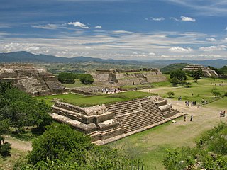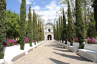
Oaxaca de Juárez, or simply Oaxaca, is the capital and largest city of the eponymous Mexican state of Oaxaca. It is the municipal seat for the surrounding municipality of Oaxaca. It is in the Centro District in the Central Valleys region of the state, in the foothills of the Sierra Madre at the base of the Cerro del Fortín, extending to the banks of the Atoyac River. Heritage tourism makes up an important part of the city's economy, and it has numerous colonial-era structures as well as significant archeological sites and elements of the continuing native Zapotec and Mixtec cultures. The city, together with the nearby archeological site of Monte Albán, was designated in 1987 as a UNESCO World Heritage Site. It is the site of the month-long cultural festival called the "Guelaguetza", which features Oaxacan dance from the seven regions, music, and a beauty pageant for indigenous women.

The Papaloapan River is one of the main rivers of the Mexican state of Veracruz. Its name comes from the Nahuatl papaloapan meaning "river of the butterflies".

Gustavo Díaz Ordaz Bolaños was a Mexican politician and member of the Institutional Revolutionary Party (PRI). He served as the President of Mexico from 1964 to 1970.

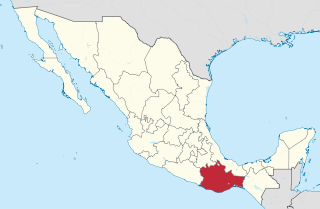
Oaxaca is a state in Southwest Mexico that is divided into 570 municipalities, more than any other state in Mexico. According to Article 113 of the state's constitution, the municipalities are grouped into 30 judicial and tax districts to facilitate the distribution of the state's revenues. It is the only state in Mexico with this particular judicial and tax district organization. Oaxaca is the tenth most populated state with 4,132,148 inhabitants as of the 2020 Mexican census and the fifth largest by land area spanning 93,757.6 square kilometres (36,200.0 sq mi).

The Church and Convent of Santo Domingo de Guzmán in the city of Oaxaca de Juárez (Mexico) is an example of New Spanish Baroque architecture. The first construction projects for the building date back to 1551, when the Antequera de Oaxaca's City Council ceded a total of twenty-four lots to the Dominican Order for the construction of a convent in the city. However, it was not until 1608 that the conventual complex of Santo Domingo was inaugurated, still unfinished.

San Pablo Villa de Mitla is a town and municipality in Mexico which is most famous for being the site of the Mitla archeological ruins. It is part of the Tlacolula District in the east of the Valles Centrales Region. The town is also known for its handcrafted textiles, especially embroidered pieces and mezcal. The town also contains a museum which was closed without explanation in 1995, since when its entire collection of Zapotec and Mixtec cultural items has disappeared. The name “San Pablo” is in honor of Saint Paul, and “Mitla” is a hispanization of the Nahuatl name “Mictlán.” This is the name the Aztecs gave the old pre-Hispanic city before the Spanish arrived and means “land of the dead.” It is located in the Central Valleys regions of Oaxaca, 46 km from the city of Oaxaca, in the District of Tlacolula.
Santo Domingo Yanhuitlán is a village and municipality in the state of Oaxaca, Mexico, located northeast of Oaxaca city. It is part of the Nochixtlán District in the southeast of the Mixteca Region. It is 2,140 meters above sea level. Its name comes from the patron saint of the town and the last part is from Náhuatl meaning “near something new”.

Tlacolula de Matamoros is a city and municipality in the Mexican state of Oaxaca, about 30 km from the center of the city of Oaxaca on Federal Highway 190, which leads east to Mitla and the Isthmus of Tehuantepec. It is part of the Tlacolula District in the east of the Valles Centrales Region.

Ocotlán de Morelos is a town and municipality in the state of Oaxaca, about 35 km south of the center of the city of Oaxaca along Highway 175. It is part of the Ocotlán District in the south of the Valles Centrales Region. The area was a significant population center at the time of the Spanish Conquest, and for that reason an important Dominican monastery was established here in the 16th century. The complex still exists, with the church still being used for worship and the cloister area used as a museum. While mostly quiet, the city is an important distribution and transportation center for the south of the Central Valleys region of Oaxaca, a function which is expected to be reinforced with the opening of new highway being built to connect the city of Oaxaca with the Pacific coast. The city is known for artist Rodolfo Morales, who painted aspects of his hometown in his works and sponsored projects to save and restore historic monuments here. For generations the municipality has been known for its crafts, with the ceramics making Aguilar family producing some of the best known craftsmen.
San Juan Teitipac is a town and municipality in Oaxaca in south-western Mexico. The municipality covers an area of 11.48 km². It is part of the Tlacolula District in the east of the Valles Centrales Region.

San Pablo Huitzo is a town and municipality in Oaxaca in south-western Mexico. The municipality covers an area of 63.80 km². It is part of the Etla District in the Valles Centrales region. As of 2005, the municipality had a total population of 5,242.
Zimatlán de Alvarez is a town and municipality in Oaxaca in south-western Mexico. The municipality covers an area of 255.16 km2. It is part of the Zimatlán District in the west of the Valles Centrales Region
Teotitlán del Valle is a small village and municipality located in the Tlacolula District in the east of the Valles Centrales Region, 31 km from the city of Oaxaca in the foothills of the Sierra Juárez mountains. It is part of the Tlacolula Valley district. It is known for its textiles, especially rugs, which are woven on hand-operated looms, from wool obtained from local sheep and dyed mainly with local, natural dyes. They combine historical Zapotec designs with contemporary designs such as reproductions of famous artists' work. Artists take commissions and participate in tours of family-owned workshops. The name Teotitlán comes from Nahuatl and means "land of the gods." Its Zapotec name is Xaguixe, which means "at the foot of the mountain." Established in 1465, it was one of the first villages founded by Zapotec peoples in this area and retains its Zapotec culture and language.

Santa Ana del Valle is a town and municipality in Oaxaca in south-western Mexico. The municipality covers an area of km². It is part of the Tlacolula District in the east of the Valles Centrales Region.

Santa Cruz Mixtepec is a town and municipality in Oaxaca in south-western Mexico. The town covers an area of 66.34 km². It is part of the Zimatlán District in the west of the Valles Centrales Region
Santo Domingo Albarradas is a town and municipality in Oaxaca in south-western Mexico. The municipality covers an area of 90.08 km². It is part of the Tlacolula District in the east of the Valles Centrales Region.
Santo Domingo Tomaltepec is a town and municipality in Oaxaca in south-western Mexico. It is part of the Centro District in the Valles Centrales region, about 10 km east of the city of Oaxaca. The municipality covers an area of 49.76 km2. The climate is mild, with little change throughout the year. Natural vegetation is semi-desert, but agricultural production of maize, beans and fruit in the heavy clay soils is highly productive.

Centro District is located in the Valles Centrales Region of the State of Oaxaca, Mexico. The district includes the state capital Oaxaca and satellite towns. The district has an average elevation of 1,550 meters. The climate is mild, with average temperatures ranging from 16°C in Winter to 25°C in spring.

Tlacolula District is located in the east of the Valles Centrales Region of the State of Oaxaca, Mexico.


