
Lexden is a suburb of Colchester, Essex, England. It was formerly a village, and has previously been called Lessendon, Lassendene and Læxadyne. Lexden is mentioned in the Domesday Book.
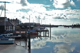
Wivenhoe is a town and civil parish in north eastern Essex, England, approximately 3 miles (5 km) south east of Colchester. Historically Wivenhoe village, on the banks of the River Colne, and Wivenhoe Cross, on the higher ground to the north, were two separate settlements but with considerable development in the 19th century the two have merged.
Layer de la Haye is a small village of around 2,000 people, measured at 1,767 in the 2011 Census, near Colchester in Essex, England.

Tiptree is a village and civil parish in the English county of Essex, situated 10 miles (16 km) south-west of Colchester and around 50 miles (80 km) north-east of London. Surrounding villages include Messing, Tolleshunt Knights, Tolleshunt Major, Layer Marney, Inworth, Birch, Great Braxted, Great Totham and Little Totham.

Essex is a county in the East of England which originated as the ancient Kingdom of Essex and one of the seven kingdoms, or heptarchy, that went on to form the Kingdom of England.

Tolleshunt Knights is a village and civil parish in the English county of Essex.

Abberton is a village in Essex, England. It is located approximately 0.62 mi (1.00 km) east of Abberton Reservoir and is 4.2 mi (6.8 km) south of Colchester. The village is in the borough of Colchester and in the parliamentary constituency of North Essex. The town is served by Abberton and Langenhoe Parish Council.

Aldham is a village and civil parish in Essex, England. It is located 4+1⁄2 mi (7.2 km) west of Colchester. The village is in the borough of Colchester and in the parliamentary constituency of Harwich and North Essex. The village has its own parish council.
Langenhoe is a village in the Colchester district of Essex, England to the south of Colchester. According to the 2001 census it had a population of 536, increasing to 572 at the 2011 Census.

Tendring is a village and civil parish in Essex. It gives its name to the Tendring District and before that the Tendring Hundred. Its name was given to the larger groupings because it was at the centre, not because it was larger than the other settlements. In 2011 the parish had a population of 736 and the district had a population of 138,048. The linear village straddles the B1035 from Manningtree to Thorpe-le-Soken.
The Colchester earthquake, also known as the Great English earthquake, occurred on the morning of 22 April 1884 at 09:18. It caused considerable damage in Colchester and the surrounding villages in Essex. In terms of overall destruction caused it is certainly the most destructive earthquake to have hit the United Kingdom in at least the last 400 years, since the Dover Straits earthquake of 1580.

Myland is a civil parish in Essex, England. It is now a northern suburb of Colchester. The original village began approximately one mile north of the centre of Colchester which probably accounts for its name. This has varied over the centuries but essentially with the same meaning. It is the only part of Colchester to be a civil parish.
Salcott or Salcott cum Virley is a village and civil parish in the Colchester borough of Essex, England, and forms part of the Winstred Hundred grouped parish council. It is adjacent to Tolleshunt Knights, Tollesbury and Great Wigborough, near Tiptree.

Great Wigborough is a village and former civil parish, now in the parish of Great and Little Wigborough in the Colchester borough of Essex, England.

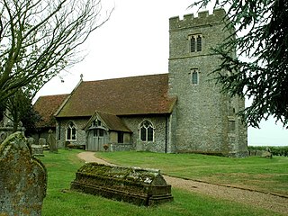
Peldon is a village and civil parish in the Colchester borough of Essex, England. With Salcott, Virley, Great Wigborough and Little Wigborough, it forms part of the Winstred Hundred parish council. Nearby villages include Langenhoe. The parish church is dedicated to St Mary the Virgin and is a Grade I listed building. The population of the parish as of the 2011 census is 559.

Layer Breton is a village and a civil parish in Essex, England. According to the 2011 census there were 144 males and 143 females. "Layer-Breton, a parish, with a village, in Lexden district, Essex; on a branch of the river Roman, 5 miles SE by S of Marks-Tey r. station, and 6 SW by S of Colchester." Layer Breton is part of the Layer parishes with Layer de la Haye being the neighbouring village to the west and Layer Marney neighbouring Layer Breton to the East. Layer Breton also touches parishes Birch and Great and little Wigborough. The village has a church dedicated to St Mary the Virgin, rebuilt in brick in 1923 on a new site nearly a mile to the north of the old one. The village was among those which suffered damage from the 1884 Colchester earthquake.

Essex is a county in the East of England. One of the home counties, it borders Suffolk and Cambridgeshire to the north, the North Sea to the east, Hertfordshire to the west, Kent across the estuary of the River Thames to the south and Greater London to the south and south-west. The county town is Chelmsford, the only city in the county. For the purposes of government statistics, Essex is placed in the East of England region.
Great and Little Wigborough is a civil parish about 6 miles (10 km) from Colchester, in the Colchester district, in the county of Essex, England. The parish includes the villages of Great Wigborough and Little Wigborough and the hamlet of Stafford's Corner on the B1026 road. In 2011 the parish had a population of 246. The parish touches Layer Breton, Layer-de-la-Haye, Layer Marney, Peldon, Salcott, Tollesbury, Tolleshunt Knights, Virley and West Mersea. The civil parish forms part of the Winstred Hundred Parish Council. There are 18 listed buildings in Great and Little Wigborough.

