Vogtsburg

Last updated
Vogtsburg
DEU Vogtsburg COA.svg
Location of Vogtsburg within Breisgau-Hochschwarzwald district
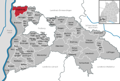
Vogtsburg im Kaiserstuhl in FR.svgEschbachFeldbergMarchMünstertalOberriedSankt PeterSchluchseeSöldenWittnau
Germany adm location map.svg
Red pog.svg
Vogtsburg
Baden-Wuerttemberg location map.svg
Red pog.svg
Vogtsburg
Coordinates: 48°05′21″N07°37′54″E / 48.08917°N 7.63167°E / 48.08917; 7.63167
Country Germany
State Baden-Württemberg
Admin. region Freiburg
District Breisgau-Hochschwarzwald
Government
   Mayor (202331) Benjamin Bohn [1]
Area
  Total37.40 km2 (14.44 sq mi)
Highest elevation
557 m (1,827 ft)
Lowest elevation
190 m (620 ft)
Population
 (2022-12-31) [2]
  Total6,242
  Density170/km2 (430/sq mi)
Time zone UTC+01:00 (CET)
  Summer (DST) UTC+02:00 (CEST)
Postal codes
79235
Dialling codes 07662
Vehicle registration FR
Website www.vogtsburg.de

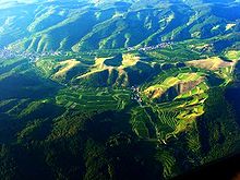
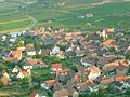
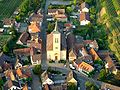
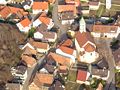
Vogtsburg im Kaiserstuhl (Low Alemannic: Vogtsburg im Kaiserstuehl), often referred to as simply Vogtsburg (German pronunciation: [ˈfoːkt͡sˌbʊʁk] ), is a town in the Kaiserstuhl, a volcanic region in the district Breisgau-Hochschwarzwald, Baden-Württemberg. It has a population of about 5,700 and was created on January 1, 1975 through the unification of six former municipalities, initially under the name Oberrotweil, [3] and was renamed to Vogtsburg im Kaiserstuhl in April 1977. [4] With its 5.4 square miles (14 km2) of vineyards, Vogtsburg is the biggest wine producing town in Germany.

Contents

Geography

Geographic position

Aerial view of the central Kaiserstuhl Kaiserstuhl Vogtsburg.jpg
Aerial view of the central Kaiserstuhl


The individual villages of Vogtsburg are embedded in the valleys of the inner Kaiserstuhl (except Burkheim). The horseshoe-shaped mountain range of the Kaiserstuhl opens to the west and forms the border of the area of Vogtsburg. To the west Vogtsburg borders the Rhine and the French region of Alsace.

Climate

The relatively low height above sea level and the protected position between the Vosges Mountains and the Schwarzwald (the Black Forest) create a nearly Mediterranean microclimate.

Geology

The mountains of the Kaiserstuhl are a later result of the creation of a great rift (the Rhine Rift) followed by some smaller volcanic activity. The Kaiserstuhl consists of thick layers of loess (100 ft (30 m)), which, together with the special climate, is the main reason for the extraordinary fertility of this area.

Neighboring towns

Divisions

The town Vogtsburg consists of the following Stadtteile or municipal divisions: [5]

  • Achkarren
  • Bickensohl
  • Bischoffingen
  • Burkheim
  • Oberbergen
  • Oberrotweil
  • Schelingen

Vogtsburg is composed of nine individual villages. Prior to unification in 1975 the villages of Oberrotweil and Niederrotweil were one political entity. The small hamlet with the original name Vogtsburg belonged to Oberbergen. For this reason the city of Vogtsburg has nine different villages but only seven political districts. Town privileges for the city of Vogtsburg came from Burkheim, which since the Middle Ages was a town despite its small size.

History

Although the city of Vogtsburg is one of the youngest in Germany, the individual villages making it up are mostly more than 1000 years old. The earliest archaeological finds in the village Oberbergen date to the times of the Linear Pottery culture during the Paleolithic era between 4000 and 2500 BC.

Archaeological finds in Bischoffingen give evidence of neolithic settlers of the Corded Ware culture. Other archeological excavations found flexed burials, which could be dated to the Bronze Age between 1700 and 1200 BC. In more recent history, from 800 BC onwards, there is extensive evidence of Celtic occupation. With the arrival of the Alemanni around 200 AD the Celts seem to have disappeared from the region. The area of Oberbergen is considered to be the most important settlement in South Baden during the era of the Hallstatt culture.

Because of the horseshoe-shaped mountain range of the Kaiserstuhl, which opens only to the west, Vogtsburg was not easily accessible before the introduction of modern roads. This led to a stagnation of development and of the population due to significant emigration until 1870. For about 100 years between 1880 and 1980 the population had been about constant at 5000 inhabitants. From 1980 on the population has increased due to development.

Policy

Municipal Council

The results of the local elections from June 13 of 2004:

FWG (Free Electors Association)49,8%+0,213 seats±0
CDU (Christian Democratic Union) 38,0%-2,99 seats-1
SPD (Social Democratic Party of Germany) 12,3%+2,93 seats+1

Economy and infrastructure

The city economy is based primarily on the production of wine grapes. In addition the production of cherries, zwetschgen, and apples contribute significantly to the economy. In recent years tourism has grown to be an important economic contributor.

Court

Vogtsburg is in the jurisdiction of the district court of Breisach.

Education

There is one general-education secondary school, two primary schools, and six kindergartens plus one nursery school. Nearby in Breisach there is a secondary school and a 'Gymnasium' (high school, grammar school).

Streets

The L113 - a country road without cross-town links runs through the western part of the city. This street goes from Breisach - Riegel to Freiamt, and then meets the L115 near Niederrotweil. The L115 goes on to Bötzingen and Umkirch. The different districts are connected with a net of district roads.

Vogtsburg is one of the rare towns without speed limit zones of 30 km/h (20 mph).

Public transport

Achkarren, Oberrotweil and Burkheim together with Bischoffingen each have a railway station for the western track of the small Kaiserstuhlbahn, a light railway leading from Breisach to Riegel. The railway traffic does not follow a fixed timetable but runs occasionally as needed. Vogtsburg is connected by bus lines to Breisach, Endingen, Bötzingen and Freiburg. All public transport is a part of a regional transport association.

Shipping

Even though Burkheim borders directly on the Rhine river, the city of Vogtsburg has no river harbor. There is a landing stage on the river to ship the grit produced by a quarry in Burkheim.

Culture and objects of interest

Museums

In 1979 the museum of viniculture in the historical 'Zehntscheur' (a barn where historic taxes were collected = 1 tenth of all produced goods) was established in Achkarren. The earliest documented reference to this building dates from 1358 as 'St. Johannser Trotte'. In Burkheim one can visit the Museum of Corkscrews.

Buildings

In the villages of Achkarren, Oberrotweil, Schelingen and Altvogtsburg there are four churches designed by Friedrich Weinbrenner, a famous architect. These four churches are typical of the style of Neoclassicism in the former state of Baden.

The church of St. Michael's in Niederrotweil dates from 1157, according to documented references. This building is famous for some recently discovered frescoes and for its wooden altar, a late masterpiece of the unknown master H. L. This altar is an extraordinary example of the baroque style of gothic art and is dated to about 1530.

The church St. Romanus in Alt-Vogtsburg was founded in 1835/36 as a subsidiary church near a country road. First a church with a capacity of 700 people was planned which would have been several times the population figure of Alt-Vogtsburg. The reduced version built by the master builder Hans Voß has a choir and two adjoining rooms. The altar comes from the workshop of Franz Xaver Marmon. The windows are from the Freiburg glass workshops of Helmle and Merzweiler. The inner part of the church is decorated with historical paintings and murals from the Freiburg painter Anselm Endress. The church is now closed due to structural deterioration caused by water intrusion and vibration from traffic. The 'Deutsche Stiftung Denkmalschutz" (German Foundation for Monument Protection) is engaged in restoration of the church.

The old town of Burkheim starts with a historical town gate. Its houses are grouped around a single paved street, and look very romantic. At the end of the town an old ruin of a castle sits atop a small mountain, below which the Rhine used to flow.

High above the village of Achkarren on the top of the Schloßberg mountain are the ruins of the castle Burg Hoehingen.

Natural monuments

There are twelve nature reserves covering a total of 280 hectares (1.1 sq mi).

Sport

Cycling races: Vogtsburg is the site of the traditional last race (king's stage) of the 'International Rothaus Regio-Tour' (sponsored by a local beer brewers company).


Sons and daughters of the town

Related Research Articles

<span class="mw-page-title-main">Freiburg im Breisgau</span> City in Baden-Württemberg, Germany

Freiburg im Breisgau is the fourth-largest city of the German state of Baden-Württemberg after Stuttgart, Mannheim and Karlsruhe. With around 236,000 inhabitants, it is Germany's 33rd-largest city. Its built-up area has a population of about 355,000 (2021) while the greater Freiburg metropolitan area ("Einzugsgebiet") has about 660,000 (2018).

Breisgau-Hochschwarzwald is a Landkreis (district) in the southwest of Baden-Württemberg, Germany. Fifty towns and municipalities with 133 settlements lie within the district. The district itself belongs to the region of Freiburg with the region of Southern Upper Rhine.

Emmendingen is a Landkreis (district) in the west of Baden-Württemberg, Germany. Neighbouring districts are Ortenaukreis, Schwarzwald-Baar, Breisgau-Hochschwarzwald and the district-free city Freiburg. To the west it borders the French département Bas-Rhin.

<span class="mw-page-title-main">Breisgau</span> Area in southwest Germany

The Breisgau is an area in southwest Germany extending along the Rhine River and enveloping portions of the Black Forest. Part of the state of Baden-Württemberg, it centers on the city of Freiburg im Breisgau. The district of Breisgau-Hochschwarzwald, which partly consists of the Breisgau, is named after the Black Forest area. Parts of the Breisgau are also situated in the political districts of Freiburg im Breisgau and Emmendingen.

<span class="mw-page-title-main">Endingen am Kaiserstuhl</span> Town in Baden-Württemberg, Germany

Endingen is a small German town located in southwest Germany, at the border with France. It lies at the northern border of a former volcano area called Kaiserstuhl. The population of Endingen is about 9,000.

<span class="mw-page-title-main">Riegel am Kaiserstuhl</span> Municipality in Baden-Württemberg, Germany

Riegel am Kaiserstuhl is a municipality in the district of Emmendingen in Baden-Württemberg, Germany. It lies 8 km northwest of Emmendingen, and is accessed by the motorway A5.

<span class="mw-page-title-main">Gottenheim</span> Independent village in the state of Baden-Württemberg, Germany

Gottenheim is an independent village at the northern tip of the Tuniberg, 15 km west of Freiburg im Breisgau. It is located in the administrative region Breisgau-Hochschwarzwald in the federal state of Baden-Württemberg, Germany.

<span class="mw-page-title-main">Breisach</span> Town in Baden-Württemberg, Germany

Breisach is a town with approximately 16,500 inhabitants, situated along the Rhine in the Rhine Valley, in the district Breisgau-Hochschwarzwald, Baden-Württemberg, Germany, about halfway between Freiburg and Colmar — 20 kilometres away from each — and about 60 kilometres north of Basel near the Kaiserstuhl. A bridge leads over the Rhine to Neuf-Brisach, Alsace.

<span class="mw-page-title-main">Kaiserstuhl (Baden-Württemberg)</span>

The Kaiserstuhl is a range of hills in the state of Baden-Württemberg in southwest Germany with a maximum height of 556.6 metres (1,826 ft). It is of volcanic origin and located in the southwest of the state in the counties of Emmendingen and Breisgau-Hochschwarzwald. In terms of natural regions it is considered to be a part of the Upper Rhine Plain.

<span class="mw-page-title-main">Bahlingen</span> Municipality in Baden-Württemberg, Germany

Bahlingen am Kaiserstuhl is a municipality in the district of Emmendingen, Baden-Württemberg, southwestern Germany.

<span class="mw-page-title-main">Ihringen</span> Municipality in Baden-Württemberg, Germany

Ihringen is a town in the district of Breisgau-Hochschwarzwald in Baden-Württemberg in Germany, just east of Breisach am Rhein and west of Freiburg im Breisgau at the southern end of the Kaiserstuhl. It is known for its wine.

<span class="mw-page-title-main">Forchheim am Kaiserstuhl</span> Municipality in Baden-Württemberg, Germany

Forchheim is the smallest municipality in the district of Emmendingen in Baden-Württemberg in Germany.

<span class="mw-page-title-main">Achkarren</span> Ortsteil of Vogtsburg in Baden-Württemberg, Germany

Achkarren, a village situated in the southern end of the small town of Vogtsburg im Kaiserstuhl, in the German Kaiserstuhl region, bordering the town of Ihringen. The valley of Achkarren faces west and is 5 km from the Rhine river and 7 km from Breisach. The highest average temperature or hotspot in Germany is located between the center of Achkarren and the town of Ihringen.

Höhingen Castle is a castle built in the Early Middle Ages on the top of the Schlossberg, a hill, above the town Achkarren, a part of the city of Vogtsburg im Kaiserstuhl in the district Breisgau-Hochschwarzwald in Baden-Württemberg in Germany.

<span class="mw-page-title-main">Kaiserstuhl Railway</span> Railway line in Baden-Württemberg, Germany

The Kaiserstuhl Railway is a railway in the German state of Baden-Württemberg. It is owned and operated by the Südwestdeutsche Verkehrs-Aktiengesellschaft (SWEG), which in turn is owned by the state of Baden-Württemberg.

<span class="mw-page-title-main">Freiburg–Colmar railway</span> Railway line in France and Germany

The Freiburg–Colmar railway was an international railway that formerly connected Freiburg im Breisgau, in the German state of Baden-Württemberg, with Colmar, in the French department of Haut-Rhin. The line crossed the river Rhine on a bridge between Breisach and Neuf-Brisach. Since that bridge was destroyed in 1945, the line from Freiburg has terminated at Breisach, and this stretch of line is now commonly called the Freiburg–Breisach railway, or the Breisacherbahn. The section from Freiburg to Breisach was completed in 1871 and the remainder in 1878.

<span class="mw-page-title-main">Freiburg (electoral district)</span> Federal electoral district of Germany

Freiburg is an electoral constituency represented in the Bundestag. It elects one member via first-past-the-post voting. Under the current constituency numbering system, it is designated as constituency 281. It is located in southwestern Baden-Württemberg, comprising the city of Freiburg im Breisgau and northwestern parts of the district of Breisgau-Hochschwarzwald.

Riegel-Malterdingen station is a station in Malterdingen on the municipal border with Riegel am Kaiserstuhl, which are both in the Emmendingen district of Baden-Württemberg, Germany. It was opened with the section of the Rhine Valley Railway from Offenburg to Freiburg on 1 August 1845. The Kaiserstuhl Railway (Kaiserstuhlbahn) of the South German Railway Company has run from a nearby terminus to Endingen since 1894. A line that branches off in Riegel Ort and runs on the eastern edge of the Kaiserstuhl to Gottenheim was opened at the same time. The line to Endingen was extended to run to the west of the mountain to Breisach in 1895.

<span class="mw-page-title-main">Breisach station</span>

Breisach station is a station in Breisach in Baden-Württemberg, Germany. It is now the starting point of the Breisach Railway to Freiburg and the Kaiserstuhl Railway (Kaiserstuhlbahn) to Riegel. The Breisach Railway crossed the Upper Rhine, running from Breisach to Colmar in France, until the destruction of the Breisach rail bridge in 1945.

<span class="mw-page-title-main">Gottenheim station</span>

Gottenheim station is a station in Gottenheim in Baden-Württemberg, Germany. It is the most important intermediate station on the Breisach Railway, which connects Freiburg and Breisach. It is also the terminus of the Kaiserstuhl Railway (Kaiserstuhlbahn), which runs to Bahlingen and Riegel Ort.

References

  1. Bürgermeisterwahl Vogtsburg im Kaiserstuhl 2023, Staatsanzeiger. Retrieved 13 June 2024.
  2. "Bevölkerung nach Nationalität und Geschlecht am 31. Dezember 2022" [Population by nationality and sex as of December 31, 2022](CSV) (in German). Statistisches Landesamt Baden-Württemberg. June 2023.
  3. Gebietsänderungen vom 01.01. bis 31.12.1975, Statistisches Bundesamt
  4. Gebietsänderungen vom 01.01. bis 31.12.1977, Statistisches Bundesamt
  5. Hauptsatzung, Stadt Vogtsburg im Kaiserstuhl, June 2020.