Voussac

Last updated

Voussac
Eglise Saint-Martin de Voussac 2019-08-22.JPG
Church Saint-Martin
Blason ville fr Voussac (Allier).svg
Location of Voussac
Voussac
France location map-Regions and departements-2016.svg
Red pog.svg
Voussac
Auvergne-Rhone-Alpes region location map.svg
Red pog.svg
Voussac
Coordinates: 46°19′43″N3°03′47″E / 46.3286°N 3.0631°E / 46.3286; 3.0631
Country France
Region Auvergne-Rhône-Alpes
Department Allier
Arrondissement Moulins
Canton Gannat
Intercommunality Commentry Montmarault Néris Communauté
Government
  Mayor (20202026) Isabelle Bidet [1]
Area
1
34.46 km2 (13.31 sq mi)
Population
 (2021) [2]
491
  Density14/km2 (37/sq mi)
Time zone UTC+01:00 (CET)
  Summer (DST) UTC+02:00 (CEST)
INSEE/Postal code
03319 /03140
Elevation359–467 m (1,178–1,532 ft)
(avg. 463 m or 1,519 ft)
1 French Land Register data, which excludes lakes, ponds, glaciers > 1 km2 (0.386 sq mi or 247 acres) and river estuaries.

Voussac (French pronunciation: [vusak] ; Occitan : Vosac) is a commune in the Allier department in Auvergne-Rhône-Alpes in central France. [3]

Contents

History

During Antiquity, the territory of Vosiacum was part of the territory of the Gallic people of the Bituriges Cubi.

In the Middle Ages, the commune was part of medieval Berry before passing into the modern-day province of Bourbonnais. The parish was part of the diocese of Bourges until the 1820s.

Geography

Voussac is located on departmental road 46, the old Route national 146, which connects Montmarault to Saint-Pourçain-sur-Sioule. The commune is bordered by Deux-Chaises to the north, Le Theil to the northeast, Fleuriel to the southeast, Target to the south, and Saint-Marcel-en-Murat to the west.

The Vacheresse Forest occupies a notable portion of the commune's territory, to the south-east of the town.

The Venant, a tributary of the Bouble, crosses the commune, flowing from north to southwest. To the south, its wooded valley separates Voussac from Saint-Marcel-en-Murat.

Climate

For the period 1971-2000, the average annual temperature was 10.3°C, with an annual thermal range of 15.9°C. The average annual cumulative precipitation was 803 mm, with 10.7 days of precipitation in January and 7.3 days in July. For the period 1991-2020, the average annual temperature observed at the nearest Météo-France meteorological station, in the town of Montmarault, 8 km as the crow flies, was 11.2 °C and the average annual cumulative of precipitation was 811.6 mm.

Population

Historical population
YearPop.±% p.a.
1968 680    
1975 514−3.92%
1982 458−1.63%
1990 400−1.68%
1999 458+1.52%
2009 465+0.15%
2014 468+0.13%
2020 489+0.73%
Source: INSEE [4]

See also

Related Research Articles

<span class="mw-page-title-main">Bouches-du-Rhône</span> Department in Provence-Alpes-Côte dAzur, France

Bouches-du-Rhône is a department in southern France. It borders Vaucluse to the north, Gard to the west and Var to the east. The Mediterranean Sea lies to the south. Its prefecture and largest city is Marseille; other important cities include Aix-en-Provence, Arles, Martigues and Aubagne.

<span class="mw-page-title-main">Drôme</span> Department in Auvergne-Rhône-Alpes, France

Drôme is the southernmost department in the Auvergne-Rhône-Alpes region of Southeastern France. Named after the river Drôme, it had a population of 516,762 as of 2019. Drôme's prefecture is Valence.

<span class="mw-page-title-main">Saonnet</span> Commune in Normandy, France

Saonnet is a commune in the Calvados department in the Normandy region in northwestern France.

<span class="mw-page-title-main">Saint-Pierre, Réunion</span> Subprefecture and commune in Réunion, France

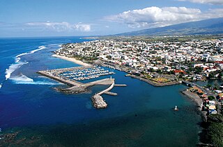
Saint-Pierre is the third-largest commune in the French overseas department and region of Réunion. Located on the southwest side of the island, it is the capital of the French Southern and Antarctic Lands. It developed from a port built from 1854 to 1882, which was used for the trade between Asia and Europe. Today, it features 400 sites for fishing and pleasure boats, while most of the commercial traffic moved north to Le Port.

<span class="mw-page-title-main">Arrondissement of Montluçon</span> Arrondissement in Auvergne-Rhône-Alpes, France

The arrondissement of Montluçon is an arrondissement of France in the Allier department in the Auvergne-Rhône-Alpes region. It has 89 communes. Its population is 108,364 (2016), and its area is 2,116.8 km2 (817.3 sq mi).

<span class="mw-page-title-main">Saint-Joseph, Réunion</span> Commune in Réunion, France

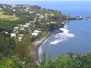
Saint-Joseph is a commune in the French overseas department of Réunion. It is located on the extreme south end of the island of Réunion. As such, it features the southernmost point of the European Union. The village Vincendo is part of the commune.

<span class="mw-page-title-main">Montauroux</span> Commune in Provence-Alpes-Côte dAzur, France

Montauroux is a commune in the Var department in the Provence-Alpes-Côte d'Azur region in Southeastern France.

<span class="mw-page-title-main">La Plaine-des-Palmistes</span> Commune in Réunion, France

La Plaine-des-Palmistes is a commune in the French overseas department of Réunion.

<span class="mw-page-title-main">Pujaut</span> Commune in Occitania, France

Pujaut is a commune in the Gard department in southern France. The village is situated on the south side of a small hill overlooking a flat plain that once formed the bed of a lake. The lake was drained at the beginning of the 17th century. The village is located 3.5 km west of the Rhône, 4.5 km north of Villeneuve-lès-Avignon and 5 km south of Roquemaure. In 2017 the commune had a population of 4,136.

<span class="mw-page-title-main">Montferrer</span> Commune in Occitania, France

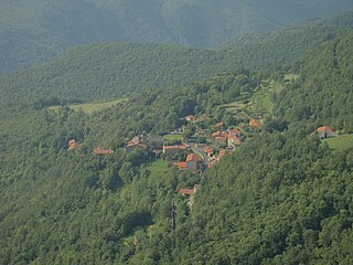
Montferrer is a commune in the southern part of the Pyrénées-Orientales department in the Occitanie region of southern France. Its inhabitants are called Montferrerois. Historically and culturally, the commune is in the Vallespir, a former viscounty, annexed to France by the Treaty of the Pyrenees (1659) and roughly corresponding to the Tech Valley from its source to Céret.

<span class="mw-page-title-main">Saint-Étienne-du-Bois, Ain</span> Commune in Auvergne-Rhône-Alpes, France

Saint-Étienne-du-Bois is a commune in the Ain department, eastern France.

<span class="mw-page-title-main">Saint-Marcel-en-Murat</span> Commune in Auvergne-Rhône-Alpes, France

Saint-Marcel-en-Murat is a commune in the Allier department in Auvergne-Rhône-Alpes in central France.

<span class="mw-page-title-main">Lanobre</span> Commune in Auvergne-Rhône-Alpes, France

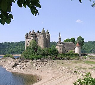
Lanobre is a commune in the south-central French department of Cantal. A 13th-century castle, the Château de Val, is located in the commune.

<span class="mw-page-title-main">Lagamas</span> Commune in Occitania, France

Lagamas is a commune in the Hérault département in the Occitanie region in southern France.

<span class="mw-page-title-main">Uxem</span> Commune in Hauts-de-France, France

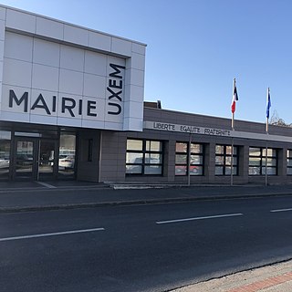
Uxem is a commune in the Nord department in northern France.

Mignaloux-Beauvoir is a commune from the Center-West of France, located in the south-eastern suburbs of Poitiers, in the Vienne department in Nouvelle-Aquitaine region.

<span class="mw-page-title-main">Saint-Michel-de-Maurienne</span> Commune in Auvergne-Rhône-Alpes, France

Saint-Michel-de-Maurienne is a commune in the Savoie department in the Auvergne-Rhône-Alpes region in south-eastern France.

<span class="mw-page-title-main">Canton of Commentry</span> Canton in Auvergne-Rhône-Alpes, France

The canton of Commentry is an administrative division in central France. At the French canton reorganisation which came into effect in March 2015, the canton was expanded from 4 to 24 communes:

The canton of Montmarault is a former administrative division in central France. It was disbanded following the French canton reorganisation which came into effect in March 2015. It had 7,991 inhabitants (2012).

References

  1. "Répertoire national des élus: les maires" (in French). data.gouv.fr, Plateforme ouverte des données publiques françaises. 13 September 2022.
  2. "Populations légales 2021" (in French). The National Institute of Statistics and Economic Studies. 28 December 2023.
  3. INSEE commune file
  4. Population en historique depuis 1968, INSEE