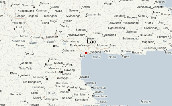
Lae (German: Preußen-Reede, later Lehe) is the capital of Morobe Province and is the second-largest city in Papua New Guinea. It is located near the delta of the Markham River and at the start of the Highlands Highway, which is the main land transport corridor between the Highlands Region and the coast. Lae is the largest cargo port of the country and is the industrial hub of Papua New Guinea. The city is known as the Garden City and home of the University of Technology.
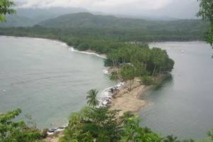
Salamaua was a small town situated on the northeastern coastline of Papua New Guinea, in Salamaua Rural LLG, Morobe province. The settlement was built on a minor isthmus between the coast with mountains on the inland side and a headland. The closest city is Lae, which can be reached only via boat across the gulf.

Morobe Province is a province on the northern coast of Papua New Guinea. The provincial capital and largest city is Lae. The province covers 33,705 km2, with a population of 674,810, and since the division of Southern Highlands Province in May 2012 it is the most populous province. It includes the Huon Peninsula, the Markham River, and delta, and coastal territories along the Huon Gulf. The province has nine administrative districts. At least 101 languages are spoken, including Kâte and Yabem language. English and Tok Pisin are common languages in the urban areas, and in some areas pidgin forms of German are mixed with the native language.
Ka Lae, also known as South Point, is the southernmost point of the Big Island of Hawaii and of the 50 United States. The Ka Lae area is registered as a National Historic Landmark District under the name South Point Complex. The area is also known for its strong ocean currents and winds and is the home of a wind farm.
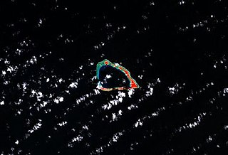
Lae Atoll is a coral atoll of 20 islands in the Pacific Ocean, and forms a legislative district of the Ralik Chain of the Marshall Islands. Its total land area is only 1.5 square kilometers (0.58 sq mi), but it encloses a lagoon with an area of 17.7 square kilometers (6.8 sq mi). It is located approximately 47 kilometers (29 mi) east of Ujae Atoll. The population of Lae Atoll was 133 in 2021. Its islands include Lae, Looj (Lotj), Bilalalon, Riblong (Ribon) and Lweijab (Lejab).

Officially named Nadzab Tomodachi International Airport, Nadzab Airport is a regional airport located at Nadzab 42 kilometres (26 mi) outside Lae, Morobe Province, Papua New Guinea along the Highlands Highway. It is served by both private and regional aircraft with domestic flights. The airport replaced the Lae Airfield in 1977.

The Salamaua–Lae campaign was a series of actions in the New Guinea campaign of World War II. Australian and United States forces sought to capture two major Japanese bases, one in the town of Lae, and another one at Salamaua. The campaign to take the Salamaua and Lae area began after the successful defence of Wau in late January, which was followed up by an Australian advance towards Mubo as the Japanese troops that had attacked Wau withdrew to positions around Mubo. A series of actions followed over the course of several months as the Australian 3rd Division advanced north-east towards Salamaua. After an amphibious landing at Nassau Bay, the Australians were reinforced by a US regimental combat team, which subsequently advanced north up the coast.
The Susuami language is a heavily endangered Papuan language, spoken in the resettlement village of Manki along the upper Watut River, Morobe Province, Papua New Guinea.
Aribwatsa, also known as Lae or Lahe, is an extinct member of the Busu subgroup of Lower Markham languages in the area of Lae, Morobe Province, Papua New Guinea. Descendants of the Aribwatsa language community have mostly switched to the Bukawa language, which is spoken all along the north coast of the Huon Gulf and in several villages on the south coast.
Kara is an Austronesian language spoken by about 5,000 people in 1998 in the Kavieng District of New Ireland Province, Papua New Guinea.
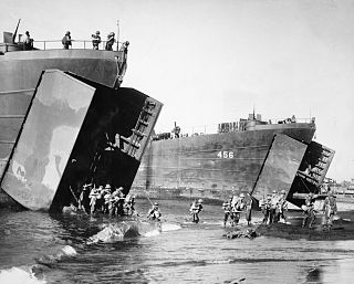
The Landing at Lae was an amphibious landing to the east of Lae and then the subsequent advance on the town during the Salamaua–Lae campaign of World War II. Part of Operation Postern, which was undertaken to capture the Japanese base at Lae, the landing was undertaken between 4 and 6 September 1943 by Australian troops from the 9th Division, supported by US naval forces from the VII Amphibious Force. The first major amphibious operation undertaken by the Australian Army since the failed Gallipoli Campaign, the Australians invested a significant amount of effort into planning the operation.
Nadzab Village is in the Markham Valley, Morobe Province, Papua New Guinea on the Highlands Highway. Administratively, it is located in Gabsongkeg ward of Wampar Rural LLG. The Nadzab Airport is located East of Nadzab Village and was the site of the only Allied paratrooper assault in New Guinea on 5 September 1943.

Left atrial enlargement (LAE) or left atrial dilation refers to enlargement of the left atrium (LA) of the heart, and is a form of cardiomegaly.
Renun River is a river in northern Sumatra, Indonesia, about 1,400 km northwest of the capital Jakarta.
The London Academy of Excellence, Stratford (LAE) is a selective free school sixth form college located in the Stratford area of the London Borough of Newham, England. It has approximately 480 pupils and 32 teachers.

Butibam is a village on the outskirts of Lae, Morobe Province in Papua New Guinea.
Bumayong is an outer suburb of Lae in the Morobe Province, Papua New Guinea.

Situm is a government ex-servicemen block outside of Lae in Labuta Rural LLG, Morobe Province, Papua New Guinea.
9 Mile is a large village in the Markham Valley of Morobe Province, Papua New Guinea. It lies along the Highlands Highway 9 miles (14 km) from the center of Lae between the foothills of the Atzera Range and the Markham River. The Atzera Range starts at Bugandi and runs adjacent to the Markham River has an elevation of 280 meters above sea level. northwest of Lae, 7 kilometres (4.3 mi) southeast of Nadzab. The landscape is typically lowland rainforest.
Lae Urban LLG is a local-level government (LLG) of Morobe Province, Papua New Guinea.
