Wahlern

Last updated
Wahlern
Wahlern-coat of arms.svg
Location of Wahlern
Wahlern
Switzerland adm location map.svg
Red pog.svg
Wahlern
Reliefkarte Bern blank.png
Red pog.svg
Wahlern
Coordinates: 46°49′N7°21′E / 46.817°N 7.350°E / 46.817; 7.350
Country Switzerland
Canton Bern
District Bern-Mittelland
Government
   Mayor Rudolf Krebs
Area
  Total40.6 km2 (15.7 sq mi)
Elevation
792 m (2,598 ft)
Population
 (31 December 2010)
  Total6,197
  Density150/km2 (400/sq mi)
Time zone UTC+01:00 (Central European Time)
  Summer (DST) UTC+02:00 (Central European Summer Time)
Postal code(s)
SFOS number 0854
LocalitiesSchwarzenburg, Lanzenhäusern, Steinenbrünnen
Surrounded by Köniz, Oberbalm, Rüeggisberg, Rüschegg, Guggisberg, Alterswil, St. Antoni, Heitenried, Albligen and Ueberstorf
Website www.wahlern.ch
SFSO statistics

Wahlern is a former municipality of the canton of Bern in Switzerland and seat of the Bern-Mittelland administrative district. On 1 January 2011, the former municipalities of Wahlern and Albligen merged in the new municipality of Schwarzenburg.

Contents

Geography

Wahlern hamlet Wahlern.jpg
Wahlern hamlet

The municipality is called Wahlern, although the chief settlement shares the name of the administrative district, Schwarzenburg. It is known as one of the transmitters of the shortwave radio station Schweizer Radio International. Other settlements in the municipality include Lanzenhäusern and Steinenbrünnen.

Wahlern lies in the Alpenvorland south of the Sense River.

Wahlern has an area of 40.5 km2 (15.6 sq mi). Of this area, 63.5% is used for agricultural purposes, while 27.3% is forested. Of the rest of the land, 7.3% is settled (buildings or roads) and the remainder (1.9%) is non-productive (rivers, glaciers or mountains). [1]

The neighboring municipalities are: Köniz, Oberbalm, Rüeggisberg, Rüschegg, Guggisberg, Alterswil, St. Antoni, Heitenried, Albligen and Ueberstorf.

Demographics

Wahlern has a population (as of 31 December 2010) of 6197. [2] As of 2007, 4.0% of the population was made up of foreign nationals. Over the last 10 years the population has grown at a rate of 2.5%. Most of the population (as of 2000) speaks German (95.9%), with French being second most common ( 0.7%) and Albanian being third ( 0.7%).

In the 2007 election the most popular party was the SVP which received 44.6% of the vote. The next three most popular parties were the SPS (19%), the FDP (10.5%) and the Green Party (10.1%).

The age distribution of the population (as of 2000) is children and teenagers (0–19 years old) make up 26.1% of the population, while adults (20–64 years old) make up 59.3% and seniors (over 64 years old) make up 14.6%. The entire Swiss population is generally well educated. In Wahlern about 74.1% of the population (between age 25-64) have completed either non-mandatory upper secondary education or additional higher education (either University or a Fachhochschule ).

Wahlern has an unemployment rate of 1.18%. As of 2005, there were 606 people employed in the primary economic sector and about 206 businesses involved in this sector. 1076 people are employed in the secondary sector and there are 73 businesses in this sector. 1189 people are employed in the tertiary sector, with 176 businesses in this sector. [1]

Transportation

Schwarzenburg is the terminal station of the Bern-Schwarzenburg-Bahn, which opened in 1907 and today forms part of the BLS AG. Lanzenhäusern also has a station.

There is no postal code for Wahlern; mail is instead shipped to 3150 Schwarzenburg or 3148 Lanzenhäusern.

Heritage sites of national significance

The farm house Aeckenmatt at Aeckenmatt 6, the ruins of Grasburg Castle, the Frühmesskapelle at Käppeligässli 5, the Rossgrabenbrücke (bridge, shared with Rüeggisberg), Schwarzenburg Castle and the granary at Henzischwand 298 A are all listed as Swiss heritage sites of national significance. [3] The entire village of Schwarzenburg and the hamlets of Äckenmatt and Elisried are designated as part of the Inventory of Swiss Heritage Sites. [4]

Related Research Articles

<span class="mw-page-title-main">Münchenwiler</span> Municipality in Bern, Switzerland

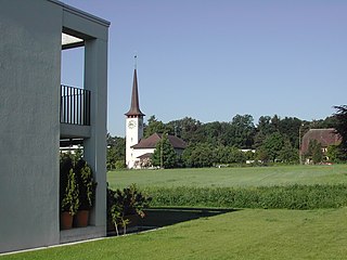
Münchenwiler is a municipality in the Bern-Mittelland administrative district in the canton of Bern in Switzerland.

<span class="mw-page-title-main">Aarburg</span> Municipality in Aargau, Switzerland

Aarburg is a historic town and a municipality in the district of Zofingen in the canton of Aargau in Switzerland.

<span class="mw-page-title-main">Aarwangen</span> Municipality in Bern, Switzerland

Aarwangen is a village and a municipality in the Oberaargau administrative district in the canton of Bern in Switzerland.

<span class="mw-page-title-main">Zollikofen</span> Municipality in Bern, Switzerland

Zollikofen is a municipality in the Bern-Mittelland administrative district in the Swiss canton of Bern. It is a suburb of the city of Bern.

<span class="mw-page-title-main">Kandergrund</span> Municipality in Bern, Switzerland

Kandergrund is a municipality in the Frutigen-Niedersimmental administrative district in the canton of Bern in Switzerland.

<span class="mw-page-title-main">Köniz</span> Municipality in Bern, Switzerland

Köniz is a statistical town and a municipality in the Bern-Mittelland administrative district right on the southern border to Bern in the canton of Bern in Switzerland. The municipality of Köniz as a single settlement would belong to the 15 most populous towns in Switzerland. It is also part of the larger agglomeration of Bern of about 400,000 inhabitants.

Albligen is a former municipality in the Bern-Mittelland administrative district in the canton of Bern in Switzerland. On 1 January 2011, the former municipalities of Wahlern and Albligen merged into the new municipality of Schwarzenburg.

<span class="mw-page-title-main">Rüschegg</span> Municipality in Bern, Switzerland

Rüschegg is a municipality in the Bern-Mittelland administrative district in the canton of Bern in Switzerland. It is also a Swiss Reformed Church parish.

<span class="mw-page-title-main">Bolligen</span> Municipality in Bern, Switzerland

Bolligen is a municipality in the Bern-Mittelland administrative district of the canton of Bern, Switzerland.

<span class="mw-page-title-main">Mühleberg</span> Municipality in Bern, Switzerland

Mühleberg is a municipality in the Bern-Mittelland administrative district in the canton of Bern in Switzerland.

<span class="mw-page-title-main">Oberdiessbach</span> Municipality in Bern, Switzerland

Oberdiessbach is a municipality in the Bern-Mittelland administrative district in the canton of Bern in Switzerland. On 1 January 2010 the former municipality of Aeschlen and on 1 January 2014, Bleiken bei Oberdiessbach merged into the municipality of Oberdiessbach.

<span class="mw-page-title-main">Schwarzenburg</span> Municipality in Bern, Switzerland

Schwarzenburg is a municipality in the district of Bern-Mittelland in the canton of Bern in Switzerland. It was created on 1 January 2011 through the merger of the municipalities of Wahlern and Albligen.

<span class="mw-page-title-main">Riggisberg</span> Municipality in Bern, Switzerland

Riggisberg is a municipality in the Bern-Mittelland administrative district in the canton of Bern in Switzerland.

<span class="mw-page-title-main">Rüeggisberg</span> Municipality in Bern, Switzerland

Rüeggisberg is a municipality in the Bern-Mittelland administrative district in the canton of Bern in Switzerland.

<span class="mw-page-title-main">Röthenbach im Emmental</span> Municipality in Bern, Switzerland

Röthenbach im Emmental is a municipality in the administrative district of Emmental in the canton of Bern in Switzerland.

<span class="mw-page-title-main">Thalheim, Aargau</span> Municipality in Aargau, Switzerland

Thalheim is a municipality in the district of Brugg in the canton of Aargau in Switzerland.

<span class="mw-page-title-main">Seewis im Prättigau</span> Municipality in Graubünden, Switzerland

Seewis im Prättigau is a Swiss village in the Prättigau and a municipality in the Prättigau/Davos Region in the canton of Graubünden.

<span class="mw-page-title-main">Rothenbrunnen</span> Municipality in Graubünden, Switzerland

Rothenbrunnen is a municipality in the Viamala Region in the Swiss canton of Graubünden.

<span class="mw-page-title-main">Sils im Domleschg</span> Municipality in Graubünden, Switzerland

Sils im Domleschg is a municipality in the Viamala Region in the Swiss canton of Graubünden.

<span class="mw-page-title-main">Sagogn</span> Municipality in Graubünden, Switzerland

Sagogn is a municipality in the Surselva Region in the canton of Graubünden in Switzerland.

References

  1. 1 2 Swiss Federal Statistical Office Archived 2011-09-04 at the Wayback Machine accessed 13-Jul-2009
  2. Swiss Federal Statistical Office - STAT-TAB Archived 2012-04-01 at the Wayback Machine , online database – Datenwürfel für Thema 01.2 - Bevölkerungsstand und -bewegung(in German) accessed 29 September
  3. Swiss inventory of cultural property of national and regional significance Archived 2009-05-01 at the Wayback Machine 21.11.2008 version, (in German) accessed 26-May-2010
  4. ISOS site accessed 26-May-2010