Related Research Articles
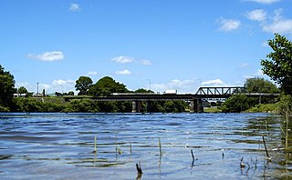
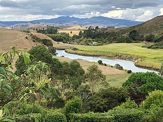
Ngāruawāhia is a town in the Waikato region of the North Island of New Zealand. It is located 20 kilometres (12 mi) north-west of Hamilton at the confluence of the Waikato and Waipā Rivers, adjacent to the Hakarimata Range. Ngāruawāhia is in the Hamilton Urban Area, the fourth largest urban area in New Zealand. The location was once considered as a potential capital of New Zealand.
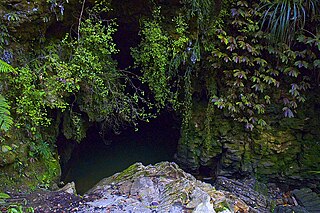
Waitomo is a rural community in the King Country region of New Zealand's North Island. There are several solutional cave systems in the area around the village, which are popular tourist attractions. Restaurants and accommodation are centred in the village to serve visiting tourists.
Ruakura is a semi-rural suburb of Hamilton City, in the Waikato region of New Zealand. The University of Waikato is nearby.
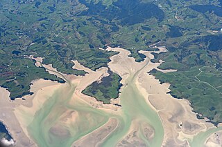
Kawhia Harbour is one of three large natural inlets in the Tasman Sea coast of the Waikato region of New Zealand's North Island. It is located to the south of Raglan Harbour, Ruapuke and Aotea Harbour, 40 kilometres southwest of Hamilton. Kawhia is part of the Ōtorohanga District and is in the King Country. It has a high-tide area of 68 km2 (26 sq mi) and a low-tide area of 18 km2 (6.9 sq mi). Te Motu Island is located in the harbour.

Port Waikato is a New Zealand town that sits on the south bank of the Waikato River, at its outflow into the Tasman Sea, in the northern Waikato.
Okoroire is a small settlement in the South Waikato District and Waikato region of New Zealand's North Island, centred around the Okoroire Hot Springs. The place name means 'place of the koroire / toroire, an extinct species of ring-necked duck.

The Moehau Range is the northernmost range on the Coromandel Peninsula, extending from the settlement of Colville, New Zealand northwards to the tip of the peninsula. Mount Moehau is the highest point of the range, at 892m above sea level.
The Mangaotaki River is a river of the southern Waikato region of New Zealand's North Island. It flows generally southeast from its sources in the coastal Herangi Range to reach the Mokau River 15 kilometres (9 mi) southwest of Piopio.
The Ōpārau River is a river of the Waikato Region of New Zealand's North Island in the area occupied by Ngāti Hikairo. It flows southwest from its sources in the Pirongia Forest Park, the highest being The Cone, and flows into the Kawhia Harbour, 5 kilometres (3 mi) east of Kawhia. The river has about 171 km (106 mi) of tributaries.
Matangi is a settlement in the Waikato District on the eastern border of Hamilton. It is surrounded by many lifestyle blocks, but the village centre has Matangi School, a garage, Four Square, takeaway and café, Matangi Hall, St David’s church and Matangi recreation reserve.

Marokopa is a rural community in Waitomo District and Waikato region of New Zealand. It is located close to the coast between Awakino and Kawhia Harbour. The meshblock includes the coastal township of Marokopa, at the mouth of the Marokopa River, and the south side of the small village of Awamarino, about 10 km (6.2 mi) upstream.
Glen Murray is a rural community in the Waikato District and Waikato region of New Zealand's North Island, on Highway 22, about 6 km (3.7 mi) up the Tikotiko Stream from Lake Whangape. In 2013 the population of meshblock 0846601, which includes Glen Murray, was 42. It has a garage and a War Memorial Hall, which opened in 1952. It is named after William Murray, who moved from Piako in 1885.
Puketotara is a rural community in the Otorohanga District and Waikato region of New Zealand's North Island.
Rangitoto is a rural community in the Waitomo District and Waikato region of New Zealand's North Island.

Anaura Bay is a bay and community in the Gisborne District of New Zealand's North Island. It is located just south of Tokomaru Bay and north of Tolaga Bay.

Taupō Central is the central suburb and business district of Taupō in the Waikato region of New Zealand's North Island.
Te Anga is a rural community in the Waitomo District and Waikato region of New Zealand's North Island.
Waotu or Te Waotu is a rural community in the South Waikato District and Waikato region of New Zealand's North Island.
Herangi Range is a range of hills south of Marokopa and north of Awakino, in the Waikato region of New Zealand, reaching to the Tasman Sea at Tapirimoko, Tirua, Taungaururoa, Te Mauku and Ngarupupu Points. Just to the south of Ngarupupu, the Waikawau River enters the sea. Other rivers draining the range are Mangaotaki River, Awakino River and Manganui River. Herangi is part of the Whareorino conservation area.

The Waikawau River is the name of two rivers on the Coromandel Peninsula in New Zealand's North Island, which each have nearby settlements called Waikawau. The more southerly flows generally west from its sources in the Coromandel Range, reaching the Firth of Thames at Waikawau Beach. This river flows south east off the Moehau Range to join the Pacific in Waikawau Bay. Both rivers were officially named on 21 June 2019.
References
- ↑ Hariss, Gavin. "Waikawau, Waikato". topomap.co.nz. NZ Topo Map.
- ↑ "Waikawau, Waikato". NZ Topo Map. Retrieved 18 February 2020.
- ↑ "Waikawau, Waikato". NZ Topo Map. Retrieved 18 February 2020.
- ↑ "2013 Census map – QuickStats about a place". archive.stats.govt.nz. Retrieved 18 February 2020.
- ↑ "Waitomo Walks" (PDF). waitomo.govt.nz. Waitomo District Council.
- ↑ Pollock, Kerryn. "Waikawau tunnel and beach". Te Ara - the Encyclopedia of New Zealand . Ministry for Culture and Heritage.
- ↑ "1000 Māori place names". New Zealand Ministry for Culture and Heritage. 6 August 2019.
- ↑ Nyika, Ruby (4 November 2018). "Crackdown on freedom camping in Waitomo ahead of summer". Stuff. Waikato Times.
- ↑ Tucker, Jim (6 August 2015). "Camper ban on whitebait fans". New Zealand Media and Entertainment. The New Zealand Herald.
- ↑ Winder, Virginia (2 May 2014). "Rich in love and laughs". Stuff. Taranaki Daily News.
- ↑ Education Counts: Whareorino School
- ↑ "New Zealand Schools Directory". New Zealand Ministry of Education. Retrieved 17 September 2024.
- ↑ "Education Review Office Report". ero.govt.nz. Education Review Office.
38°28′20″S174°40′50″E / 38.472340°S 174.680632°E
| | This Waikato geography article is a stub. You can help Wikipedia by expanding it. |