
Coaldale is a town in southern Alberta, Canada, located 11 km (6.8 mi) east of Lethbridge, along the Crowsnest Highway. Coaldale became a village in 1919 and then became incorporated as a town in 1952.

Fort Victoria, near present-day Smoky Lake, Alberta, was established by the Hudson's Bay Company in 1864 on the North Saskatchewan River as a trading post with the local Cree First Nations. Today, it is a historical museum known as Victoria Settlement.

Unorganized North Algoma District is an unorganized area in northeastern Ontario, Canada, comprising all areas in Algoma District, north of the Sault Ste. Marie to Elliot Lake corridor, which are not part of an incorporated municipality or a First Nation. It covers 44,077.03 km2 (17,018.24 sq mi) of land, and had a population of 5739 in 2016.

Duhamel is a hamlet in the central Alberta, Canada within Camrose County. It is located on Highway 21, approximately 100 kilometres (62 mi) southeast of Edmonton and 20 kilometres (12 mi) southwest of Camrose, Duhamel's closest major trading centre.
Endiang, Alberta is a hamlet in Alberta, Canada within the County of Stettler No. 6. It is located approximately 80 kilometres (50 mi) southeast of Stettler, Alberta.
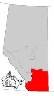
Southern Alberta is a region located in the Canadian province of Alberta. In 2004, the region's population was approximately 272,017. The primary cities are Lethbridge and Medicine Hat. The region is known mostly for agricultural production, but other sectors, such as alternative energy, film production and tourism, are emerging.

Wrentham is a hamlet in southern Alberta, Canada within the County of Warner No. 5. It is located southeast of the intersection of the Veteran Memorial Highway and the historic Red Coat Trail, approximately 25 kilometres (16 mi) east of the Village of Stirling, 30 kilometres (19 mi) south of the Town of Taber and 55 kilometres (34 mi) west of the Village of Foremost.

Wostok is a hamlet in Alberta, Canada within Lamont County. It is located on Range Road 173, approximately 5 kilometres (3.1 mi) south of Highway 45 and 8 kilometres (5.0 mi) north of Highway 29. Lamont is approximately 23 kilometres (14 mi) southwest of Wostok.
Bellis is a hamlet in central Alberta, Canada within Smoky Lake County. Previously an incorporated municipality, Bellis dissolved from village status on January 1, 1946 to become part of the Municipal District of Vilna No. 575.
Edwand is a hamlet in central Alberta, Canada within Smoky Lake County. It is located 4 kilometres (2.5 mi) north of Highway 28, approximately 104 kilometres (65 mi) northeast of Edmonton.
Gem is a hamlet in southern Alberta, Canada within the County of Newell. It is located approximately 29 kilometres (18 mi) north of Highway 1 and 47 kilometres (29 mi) northwest of Brooks.
Long Lake is a hamlet in central Alberta, Canada within Thorhild County. It is located on the west shore of Long Lake, approximately 12 kilometres (7.5 mi) east of Highway 63 and 114 kilometres (71 mi) northeast of Edmonton.
Patricia is a hamlet in southern Alberta, Canada within the County of Newell. It is located approximately 20 kilometres (12 mi) north of Highway 1 and 21 kilometres (13 mi) northeast of Brooks.
Queenstown is a hamlet in southern Alberta, Canada within Vulcan County. It is located approximately 26 kilometres (16 mi) south of Highway 1 and 92 kilometres (57 mi) southeast of Calgary.
Rainier is a hamlet in southern Alberta, Canada within the County of Newell. It is located 5 kilometres (3.1 mi) west of Highway 36 and approximately 26 kilometres (16 mi) southwest of Brooks.
Rumsey is a hamlet in southern Alberta, Canada within Starland County. It is located 8 kilometres (5.0 mi) west of Highway 56, approximately 80 kilometres (50 mi) southeast of Red Deer.

Scandia is a hamlet in Alberta, Canada within the County of Newell. It is located 2 kilometres (1.2 mi) west of Highway 36, approximately 34 kilometres (21 mi) southwest of Brooks.
Shouldice is a hamlet in southern Alberta, Canada within Vulcan County. It is located approximately 16 kilometres (9.9 mi) south of Highway 1 and 85 kilometres (53 mi) southeast of Calgary.
Lake Newell Resort is a hamlet in southern Alberta, Canada within the County of Newell that was established in 2007.
Welling Station is a hamlet in southern Alberta, Canada within Cardston County.


