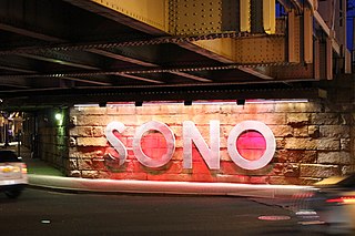
South Norwalk is a neighborhood and the Second Taxing District in Norwalk, Connecticut. The neighborhood was originally a settlement called 'Old Well' which became chartered as the city of 'South Norwalk' on August 18, 1870. The cities of Norwalk and South Norwalk were incorporated on June 6, 1913. The neighborhood is often referred to with the acronym 'SoNo'.

Sheffield Island Light is a historic lighthouse located at the southern end of the Norwalk Islands in Norwalk, Connecticut. It marks the west side of the mouth of the Norwalk River on northern Long Island Sound.
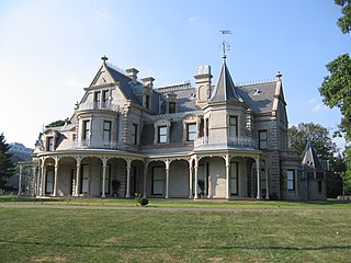
The Lockwood–Mathews Mansion is a Second Empire style country house, now a museum, at 295 West Avenue in Norwalk, Connecticut. It was built in 1864-68 by railroad and banking magnate LeGrand Lockwood. The 62-room 44,000 square feet (4,100 m2) mansion was listed on the National Register of Historic Places and was declared a National Historic Landmark in 1978.

Silvermine is an unincorporated community in Fairfield County, Connecticut, United States. The settlement is within the city limits of Norwalk.

The Main Street Historic District in Cromwell, Connecticut is roughly bounded by Nooks Hill Rd., Prospect Hill Rd., Wall and West Sts. and New Ln., and Stevens Ln. and Main St.

The Georgetown Historic District is a historic district which covers the central portion the village of Georgetown, Connecticut. The district includes parts of Georgetown in the towns of Redding and Wilton and consists of the former Gilbert & Bennett manufacturing plant, institutional housing built for the plant workers, and other private homes.

The Norwalk Green Historic District is a historic district in the Central Norwalk section of Norwalk, Connecticut. The district is centered on the Norwalk Green, a common area until 1851. It includes St. Paul's Episcopal Church and the First Congregational Church, both of which face the green. The district contains 54 contributing buildings, 3 contributing sites, and 1 other contributing object, most of which were designed in the 18th and 19th centuries. The district is irregular in shape, drawn to include historic properties in the vicinity of the Norwalk Green, but to exclude non-historic properties.

Built in 1906, Beth Israel Synagogue is an historic Orthodox synagogue building located at 31 Concord Street in the South Norwalk section of the city of Norwalk, Connecticut. The Moorish Revival style building is the only known synagogue building in Connecticut displaying Moorish onion domes, and is an unusual example of an urban wood-frame synagogue. Since 1972, the building has been owned and occupied by the Canaan Institutional Baptist Church.

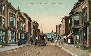
The South Main and Washington Streets Historic District — 68-139 Washington St. and 2-24 South Main St. is a historic district in South Norwalk, Connecticut. The 110-acre (45 ha) district encompasses 35 buildings and two other structures. Varied architectural styles from the late 19th and early 20th centuries include Romanesque Revival, Second Empire, and Italianate architecture. Half of the area first became part of the National Register of Historic Places in 1977. The district was increased in 1985 with the addition of nine buildings on 2.5 acres (1.0 ha) and again in 1999, with another 10 buildings on 3 acres (1.2 ha), roughly along North Main Street from Washington Street to Ann Street.

The Norwalk River Railroad Bridge is a swing bridge built in 1896 for the New York, New Haven and Hartford Railroad. It currently carries Amtrak and Metro-North Railroad trains over the Norwalk River.
The South Norwalk Railroad Bridge is an 1895 bridge in Norwalk, Connecticut. It carries the four sets of Metro-North railroad tracks across the busy intersection of Main Street and Washington Street in the South Norwalk section of the city. The bridge is adjacent to the South Norwalk Switch Tower Museum, which showcases the railroad switch tower where tracks were physically switched at the intersection of the Danbury Branch and the New Haven Line.

The Joseph Loth Company Building is a historic industrial building at 25 Grand Street in Norwalk, Connecticut. It is a two-story brick Romanesque Revival structure with a four-story clock tower. The rear of the building has been altered by the addition of modern concrete sections in the 1950s. Built in 1903, it is a well-preserved example of industrial architecture of the period, and is a local landmark.

The Fairfield County Courthouse, also known as the Court of Common Pleas, is located at 172 Golden Hill Street in downtown Bridgeport, Connecticut. It is also known as Geographical Area (GA) Courthouse No. 2 at Bridgeport.
The Five Mile River Landing Historic District in the Rowayton section of Norwalk, Connecticut is a historic district that was listed on the National Register of Historic Places in 2009. It extends along Rowayton Street from Witch Lane to Pennoyer Street, and includes all of the properties on the latter as well. The area was a major local center of the shipping industry in the 19th century.

The Haviland and Elizabeth Streets–Hanford Place Historic District is an irregularly shaped 4.3-acre (1.7 ha) historic district in Norwalk, Connecticut that was listed on the National Register of Historic Places in 1988.

The US Post Office–South Norwalk Main, also known as Norwalk Main Post Office, is located at 16 Washington Street in Norwalk, Connecticut. It is a single story steel and concrete structure, faced in limestone. It was designed in 1936, and built in 1937 with funding from the Works Progress Administration, and is an example of what has been termed "starved classicism". Its lobby areas are decorated by murals by Kindred McLeary (1901-1949) and other artists, funded by the Treasury Department's Section of Painting and Sculpture.

Hebron Center Historic District encompasses most of the historic village center of Hebron, Connecticut. Centered on the junction of Connecticut Routes 66 and 85, it has served as the rural community's civic center since its incorporation in 1708. The district was listed on the National Register of Historic Places in 1993.


