Warbys Barn and Stables

Last updated

Warbys Barn and Stables
497 - Warbys Barn & Warbys Stables - Warby's Barn; front view (5045445b2).jpg
Front view
Location14 - 20 Queen Street, Campbelltown, City of Campbelltown, New South Wales, Australia
Coordinates 34°03′30″S150°49′25″E / 34.0582°S 150.8235°E / -34.0582; 150.8235 Coordinates: 34°03′30″S150°49′25″E / 34.0582°S 150.8235°E / -34.0582; 150.8235
Built1816
ArchitectJohn Warby
Official nameWarbys Barn & Warbys Stables; The Leumeah Barn; Leumeah Barn Restaurant; Campbelltown Motor Inn
TypeState heritage (built)
Designated2 April 1999
Reference no.497
TypeStables
CategoryFarming and Grazing
Location map Australia Sydney.png
Red pog.svg
Location of Warbys Barn and Stables in Sydney

Warbys Barn and Stables is a heritage-listed former barns and now commercial building at 14 - 20 Queen Street, Campbelltown in the City of Campbelltown local government area of New South Wales, Australia. It was designed by John Warby and built in 1816. It is also known as Warbys Barn and Warbys Stables, The Leumeah Barn, Leumeah Barn Restaurant and Campbelltown Motor Inn. It was added to the New South Wales State Heritage Register on 2 April 1999. [1]

Contents

History

Campbelltown

Permanent European settlement in the Campbelltown area had begun in 1809 as an alternative to the flood-prone Hawkesbury district. Work on a road from Sydney to Liverpool was started in 1811. It was opened in August 1814 and was soon extended further south to Appin. This road, variously known as Campbelltown Road, Appin Road or the Sydney Road, passed through Campbelltown. The section through the town was called the High Street until the last decade of the 19th century when it was renamed Queen Street. [1] [2]

The land on which the Queen Street cottages stand was part of a grant of 57 hectares (140 acres) to Joseph Phelps in 1816. He had been working the land for some years before receiving formal title to it. Phelps was one of the farmers of Airds and Appin who subscribed funds for a Sydney courthouse in July 1813. His grant was seized, possibly as soon as it was formally issued, by the provost marshal, William Gore, in lieu of payment by Phelps of debts totalling 170 pounds. The land was auctioned in January 1817 to William Bradbury for 100 pounds plus twelve cattle and the grain produced from the crop growing on the land. [1] [2]

Immediately north of Phelps' grant, Assistant Surveyor James Meehan had informally reserved 71 hectares (175 acres) for a village (AMCG, 1994 say "in 1815".) In 1816 most of the land in the area was granted, leaving a portion of 71 hectares (175 acres) unalienated, and surrounded by several grants. [1] [3]

The reserved land was formally declared a town by Governor Macquarie in December 1820 and named Campbelltown in honour of his wife (Elizabeth)'s family. [1] [2]

William Bradbury (1774-1836) a native of Birmingham, was transported to NSW aboard the "Guildford" in 1812. His wife Elizabeth remained in England but his daughter, Mary (1797-1852) followed her father to Australia in 1815. Bradbury had no other children in NSW, though he established a relationship with a woman named Alice and in April 1836 married a Campbelltown widow, Catherine Patrick, née Acres (c.1801-1883). Bradbury died two months later. [3] [1]

Governor Macquarie visited Campbelltown in January 1822. He and his party ate a "hearty" breakfast at 'Bradbury's', indicating that Bradbury had built an inn. This was probably the inn later known as the Royal Oak, on the western side of the High Street. Macquarie noted in his journal that 'Bradbury is building a very good two storey brick house on his own farm and on a very pretty eminence immediately adjoining Campbell-Town as an inn for the accommodation of the public, and having asked me to give his farm a name, I have called it Bradbury Park. In 1826 Bradbury Park House was considered by William Dumaresq, inspector of roads and bridges, as the best building in Campbelltown when he reported on buildings suitable for military use. [3] [1]

As the main street of Campbelltown, High Street or Sydney Road and later Queen Street, was at the edge of town, one side of the street was not within the town boundary while the other was. Canny traders soon realised that either side of the main road was as good as the other and leased or bought land from the grantees bordering the town proper. By the 1840s more than a few shops and hotels occupied the western side of the High Street. The coming of the railway in 1858 also aided in securing the commercial focus of the town on Queen Street. [3] [1]

The Queen Street terraces were identified by Helen Baker (Proudfoot) in the early 1960s as a unique group of two-storey late Georgian vernacular buildings which were considered to form the only surviving late-1840s streetscape within the County of Cumberland. The buildings were acquired by the Cumberland County Council and its successors, the State Planning Authority and Department of Planning, to ensure their preservation. [3] [1]

Warby's Barn

The barn, before its conversion into flats 497 - Warbys Barn & Warbys Stables - Warby's Barn; before conversion to flats (5045445b1).jpg
The barn, before its conversion into flats

John Warby (1744? - 1851), a convict, explorer and later farmer was convicted at Hertford England on 3 March 1791 and sentenced to transportation for seven years. He reached Sydney in February 1792 in the ship, "Pitt". On 12 September 1796 he married another convict, Sarah Bentley (1780-1869) who had arrived in the Indispensable in April 1796 at Parramatta. They had nine sons and five daughters. One of the sons, John Warby was the first settler in the North Gundagai area. [1]

Warby settled on 20 hectares (50 acres) at Prospect after his sentence expired. In 1803 he was appointed stockman of the wild cattle at large in the Cowpastures. [1]

Warby became well known as an explorer and guide in the Camden area and Burragorang Valley, leading Governor Macquarie and his party from Prospect Hill through the Cowpastures in November 1810 and again in October 1815 on an expedition along the Nattai River. [1]

In June 1816 and at the age of 49, he was rewarded for his public services with a grant of 105 hectares (260 acres) at Campbelltown. In the same year Warby built the first three rooms of Leumeah House, the stables and the barn. Further work to the main house using sandstock bricks was subsequently done in 1826. At one time there were no less than 40 servants housed in the stables to service the needs of the Warby establishment, At age 84 John Warby died on 12 June 1851. Sarah Warby lived on at Campbelltown and died there on 19 October 1869. [1] [4]

Leumeah House was demolished in 1963, but the barn and stables associated with the farmstead survived. [1]

In 1962 Mr John Feeney purchased The Leumeah Barn (Warby's Barn) and Warbys Stables which were now in a derelict condition. Feeney restored and renovated the building converting it into a residence. In completing the work care was taken not to alter the exterior of the building and to retain many of the original features such as the fireplace, half log roof beams, the carriage arch and the window and door openings. [1] [5]

In 1979 Feeney sold the property and the barn was converted into a block of flats and the stables into a restaurant called Sids Leumeah Barn Restaurant. [1] [6]

During 1985 the Heritage Council received community strong representation expressing concern for the future of Warby's Barn and Warby's Stable. On 24 March 1985 the Heritage Council recommended the placing of an Interim Heritage Order over Warby's Barn and Warby's Stable. An Interim Heritage Order was placed on 31 May 1985. The order was placed to provide time for further inquiry and investigation to determine whether it was necessary to warrant the making of a Permanent Conservation Order. [1]

On 26 June 1985 the Heritage Council approved, subject to conditions, the conversion of Warby's Barn to a Motor Inn. [1]

On 25 November 1986 the Heritage Council recommended placing a Permanent Conservation order over Warby's Barn and Warby's Stable. Public notice was given of the proposal to place a Permanent Conservation Order. The Heritage Council received an objection to the extent of the listing. [1]

To ensure continued protection a second Interim Conservation Order was placed 22 May 1987. Following discussion with the owner of Warby's Barn and Warby's Stable an adjustment to the proposed boundary of the Permanent Conservation Order was made. The objection to the Permanent Conservation Order was subsequently withdrawn. [1]

The Permanent Conservation order was placed on 22 January 1988. Warby's Barn and Warby's Stable was listed on the State Heritage Register on 2 April 1999. [1]

By 2011 after being empty for a number of years Warbys Barn was converted into a health centre. [1] [5]

Description

Both buildings are simple sandstone structures rectangular in shape with gable roofs. The barn had large central arched openings in front and rear and symmetrically placed patterned ventilation gaps in the stonework. These have been removed through the insertion of windows and doorways. The stables are less altered. Porches have been added to both buildings. [6] [1]

Condition

As at 14 March 2001, archaeological potential is high. [1]

Heritage listing

Heritage boundaries 497 - Warbys Barn & Warbys Stables - PCO Plan Number 497 (5045445p1).jpg
Heritage boundaries

As at 22 October 2012, the Leumeah Barn (Warby's Barn) and Warby's Stable are significant remains of one of the earliest farms of the Campbelltown district. Their strong historical associations with the district's evolution and settlement pattern are reinforced by their location within a suburb names after Leumeah House. [6] [1]

Warbys Barn & Stables was listed on the New South Wales State Heritage Register on 2 April 1999. [1]

Related Research Articles

<span class="mw-page-title-main">Campbelltown, New South Wales</span> City in New South Wales, Australia

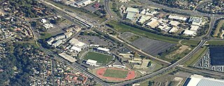
Campbelltown is a suburb located on the outskirts of the metropolitan area of Sydney, New South Wales, Australia. It is located in Greater Western Sydney 53 kilometres (33 mi) south-west of the Sydney central business district by road. Campbelltown is the administrative seat of the local government area of the City of Campbelltown. It is also acknowledged on the register of the Geographical Names Board of New South Wales as one of only four cities within the Sydney metropolitan area.

<span class="mw-page-title-main">City of Campbelltown (New South Wales)</span> Local government area in New South Wales, Australia

The City of Campbelltown is a local government area in the Macarthur region of south-western Sydney, in New South Wales, Australia. The area is located about 55 kilometres (34 mi) south west of the Sydney central business district and comprises 312 square kilometres (120 sq mi).

<span class="mw-page-title-main">Leumeah, New South Wales</span> Suburb of Sydney, New South Wales, Australia

Leumeah is a suburb of Sydney, in the state of New South Wales, Australia 52 kilometres south-west of the Sydney central business district, in the local government area of the City of Campbelltown. It is north of the suburb of Campbelltown and is part of the Macarthur region.

<span class="mw-page-title-main">Macarthur, New South Wales</span> Region in South Western Sydney

Macarthur is a region in the south-west of Sydney, in the state of New South Wales, Australia. The region includes the local government areas of the City of Campbelltown, Camden Council, and Wollondilly Shire. It covers an area of 3,067 square kilometres and has a population of close to 310,000 residents. The region geographically forms the foothills between the Blue Mountains and Southern Highlands regions.

<span class="mw-page-title-main">Appin, New South Wales</span> Town in New South Wales, Australia

Appin is a town in the Macarthur Region in Tharawal country near its boundary with Gandangara country, New South Wales, Australia in Wollondilly Shire. It is situated about 16 kilometres (9.9 mi) south of Campbelltown and 35 kilometres (22 mi) northwest of Wollongong.

<span class="mw-page-title-main">Elizabeth Macquarie</span>

Elizabeth Macquarie was the second wife of Lachlan Macquarie, who served as Governor of New South Wales from 1810 to 1821. She played a significant role in the establishment of the colony and is recognised in the naming of many Australian landmarks including Mrs Macquarie's Chair and Elizabeth Street, Hobart. Governor Macquarie named the town of Campbelltown, New South Wales after his wife's maiden name and a statue of her now stands in Mawson Park, Campbelltown.

<span class="mw-page-title-main">Glenalvon House</span> Historic site in New South Wales, Australia

Glenalvon House is a heritage-listed homestead located at 8 Lithgow Street, Campbelltown in the City of Campbelltown local government area of New South Wales, Australia. It was designed and built in 1841 by Michael Byrne. It is also known as Glenalvon and Glenalvon and Stables. The property is owned by Department of Planning and Infrastructure, an agency of the Government of New South Wales. It was added to the New South Wales State Heritage Register on 2 April 1999.

Windmill Hill is a heritage-listed former farm and now water catchment area located at Wilton Road in the outer south-western Sydney settlement of Appin in the Wollondilly Shire local government area of New South Wales, Australia. It was built from 1820 to 1950. It is also known as Windmill Hill Group, including Ruins, North Farm, Middle Farm aka Larkin Farm and Windmill Hill, South Farm and Steven's Homestead. The property is owned by Water NSW. It was added to the New South Wales State Heritage Register on 27 June 2014.

<span class="mw-page-title-main">Macquarie Arms Inn</span> Historic site in New South Wales, Australia

Macquarie Arms Inn is a heritage-listed former inn and now residence at 104-106 Bathurst Street, Pitt Town, City of Hawkesbury, New South Wales, Australia. It was also known as the Blighton Arms and Flemings Public House in its time as an inn, while the main house on the property became known as Mulgrave Place. It was added to the New South Wales State Heritage Register on 2 April 1999.

<span class="mw-page-title-main">Campbelltown Post Office</span> Historic site in New South Wales, Australia

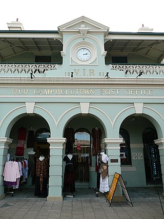
The Campbelltown Post Office is a heritage-listed former post office and now shops and office space at 261 Queen Street, Campbelltown, City of Campbelltown, New South Wales, Australia. It was designed by James Barnet and built in 1881. It is also known as Campbelltown Post Office (former). The property is privately owned. It was added to the New South Wales State Heritage Register on 2 April 1999.

<span class="mw-page-title-main">Dredges Cottage</span> Historic site in New South Wales, Australia

Dredges Cottage is a heritage-listed former cottage and now office located at 303 Queen Street, Campbelltown in the City of Campbelltown local government area of New South Wales, Australia. The property is owned by Campbelltown City Council. It was added to the New South Wales State Heritage Register on 2 April 1999.

<span class="mw-page-title-main">Commercial Banking Company of Sydney, Campbelltown Branch (former)</span> Historic site in New South Wales, Australia

Commercial Banking Company of Sydney (CBC), Campbelltown Branch is a heritage-listed former restaurant, offices and bank building and now medical centre located at 263 Queen Street, Campbelltown in the City of Campbelltown local government area of New South Wales, Australia. It was designed by Mansfield Brothers and built from 1874 to 1881. It is also known as Old CBC Bank; CBC Bank. The property is privately owned. It was added to the New South Wales State Heritage Register on 2 April 1999.

<span class="mw-page-title-main">Robin Hood Farm</span> Historic site in New South Wales, Australia

Robin Hood Farm is a heritage-listed former dairy farm homestead and now adolescent drug rehabilitation centre located at 196 Campbelltown Road, Ingleburn, in the City of Campbelltown local government area of New South Wales, Australia. It was built from 1860 to 1862 by Richard Watson. It is also known as Robin Hood Inn and Waratah Dairies. The property is owned by Department of Planning and Infrastructure, a department of the Government of New South Wales. It was added to the New South Wales State Heritage Register on 2 April 1999.

<span class="mw-page-title-main">Queen Street Buildings</span> Historic site in New South Wales, Australia

Queen Street Buildings is a heritage-listed former shops and hotel at 284 - 298 Queen Street, Campbelltown in the City of Campbelltown local government area of New South Wales, Australia. It was built by John Doyle (hotel); William Bursill. It is also known as Queen Street Buildings Group, McGuanne House, Old Railway Hotel, William Bursill's Shop and The Coach House. The property is owned by Minister For Administering The Environmental & Planning Act, 1979. It was added to the New South Wales State Heritage Register on 2 April 1999.

<span class="mw-page-title-main">St John's Catholic Church, Campbelltown</span> Church in New South Wales, Australia

St John's Roman Catholic Church and Cemetery is a heritage-listed former school and now Roman Catholic church building located in George Street in Campbelltown. It was designed by John Joseph Therry and built from 1824 to 1841. It is also known as St Johns Roman Catholic Church and Cemetery (former), Saint Johns Roman Catholic Church and Old St John's Church. It was added to the New South Wales State Heritage Register on 2 April 1999. The current church, called St John the Evangelist Catholic Church was built in 1886 and is located at Cordeaux Street, Campbelltown in the City of Campbelltown local government area of New South Wales, Australia. The property is owned by Trustees of the Roman Catholic Church for the Diocese of Wollongong.

<span class="mw-page-title-main">St Helen's Park</span> Historic site in New South Wales, Australia

St Helen's Park is a heritage-listed former school, experimental farm, private residence and guesthouse and now homestead located at St Helens Park Drive, St Helens Park, City of Campbelltown, New South Wales, Australia. It was designed by George Allen Mansfield and built in 1887 by George Lusted. It is also known as St. Helen's Park and Egypt Farm. The property is privately owned. It was added to the New South Wales State Heritage Register on 2 April 1999.

<i>Denfield</i> Historic site in New South Wales, Australia

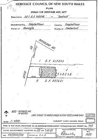
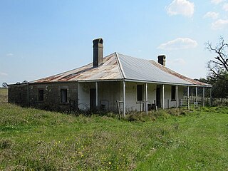
Denfield is a heritage-listed former farm homestead complex, residence, inn and farm and now residence located at Appin Road, St Helens Park in the City of Campbelltown local government area of New South Wales, Australia. It was built in 1837 by John Farley. It was added to the New South Wales State Heritage Register on 2 April 1999.

<span class="mw-page-title-main">Glenlee, Menangle Park</span> Historic site in New South Wales, Australia

Glenlee is a heritage-listed former dairy farm, pastoral property and hay production and now olive farm, private home and pastoral property at Glenlee Road, Menangle Park, City of Campbelltown, New South Wales, Australia. It was designed by Henry Kitchen and built from 1824 to 1859 by Robert Gooch and Nathaniel Payton. It is also known as Glenlee, outbuildings, garden & gatelodge. It was added to the New South Wales State Heritage Register on 2 April 1999.

<span class="mw-page-title-main">Macquarie Field House</span> Historic site in New South Wales, Australia

Macquarie Field House is a heritage-listed former farm, private school and homestead and now residence at Quarter Sessions Road, Macquarie Fields, City of Campbelltown, New South Wales, Australia. It was designed by James Meehan, James Hume and built from 1810 to 1843 by James Meehan ; Mr Burns. It is also known as Macquarie Field House and the Meehan remains; Macquariefield, Macquarie Fields and Macquarie Field. The property is privately owned. It was added to the New South Wales State Heritage Register on 2 April 1999.

<span class="mw-page-title-main">Beulah, Gilead</span> Historic site in New South Wales, Australia

Beulah is a heritage-listed farm at 767 Appin Road, Gilead, City of Campbelltown, New South Wales, Australia. It was built from 1835 to 1846 by Cornelius O'Brien, Duncan Cameron, John Kennedy Hume, Ellen Hume; Mansfield Brothers. It is also known as Summer Hill; Summer Hill Estate. The property is privately owned. It was added to the New South Wales State Heritage Register on 2 April 1999.

References

  1. 1 2 3 4 5 6 7 8 9 10 11 12 13 14 15 16 17 18 19 20 21 22 23 24 25 26 "Warbys Barn & Warbys Stables". New South Wales State Heritage Register . Department of Planning and Environment. H00497. Retrieved 1 June 2018. CC-BY icon.svg Text is licensed by State of New South Wales (Department of Planning and Environment) under CC-BY 4.0 licence .
  2. 1 2 3 Orwell & Peter Phillips, 1995, vol.2, 1-2.
  3. 1 2 3 4 5 AMCG, 1994, 9.
  4. Australian Dictionary of Biography.
  5. 1 2 Feeney, 2012.
  6. 1 2 3 Branch Managers Report to the Heritage Council, 24 April 1985.

Bibliography

Attribution

CC BY icon-80x15.png This Wikipedia article was originally based on Warbys Barn & Warbys Stables , entry number 00497 in the New South Wales State Heritage Register published by the State of New South Wales (Department of Planning and Environment) 2018 under CC-BY 4.0 licence , accessed on 1 June 2018.