Ward, Alabama | |
|---|---|
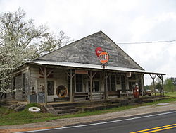 Store in Ward, 2008 | |
 Ward, Alabama  Ward, Alabama | |
| Coordinates: 32°21′44″N88°16′41″W / 32.36222°N 88.27806°W | |
| Country | United States |
| State | Alabama |
| County | Sumter |
| Elevation | 203 ft (62 m) |
| Time zone | UTC-6 (Central (CST)) |
| • Summer (DST) | UTC-5 (CDT) |
| ZIP code | 36922 |
| Area codes | 205, 659 |
| GNIS feature ID | 153882 [1] |
Ward is an unincorporated community in Sumter County, Alabama, United States. [1] Its ZIP code is 36922. [2]
