Warren, New South Wales

Last updated

Warren
New South Wales
Warren Sporting Grounds.JPG
Warren, NSW.
Australia New South Wales location map blank.svg
Red pog.svg
Warren
Coordinates 31°42′S147°50′E / 31.700°S 147.833°E / -31.700; 147.833
Population1,530 (2016 census) [1]
Postcode(s) 2824
Elevation198 m (650 ft)
Location
LGA(s) Warren Shire
State electorate(s) Barwon
Federal division(s) Parkes
Mean max tempMean min tempAnnual rainfall
25.2 °C
77 °F
10.5 °C
51 °F
515.8 mm
20.3 in

Warren is a town in the Orana Region of New South Wales, Australia. It is located off the Mitchell Highway, 120 kilometres north west of Dubbo, and is the seat of the Warren Shire local government area. At the 2016 census, Warren had a population of 1,530. [1] Warren is included in the Central West Slopes and Plains division of the Bureau of Meteorology forecasts. [2]

Contents

Looking to the East of Warren before entering town Warren NSW, entrance coming from Nevertire.JPG
Looking to the East of Warren before entering town
Purple sunrise over the white and gold cotton, taken from farm in Warren Cotton bales sunrise WARREN.JPG
Purple sunrise over the white and gold cotton, taken from farm in Warren
Channel Irrigation for Cotton Farmers in Warren, 3 inch pipes Channel Irrigation of cotton crops WARREN.JPG
Channel Irrigation for Cotton Farmers in Warren, 3 inch pipes

History

Before European settlement the area is said to have been occupied by the Ngiyambaa Aborigines. Explorer John Oxley camped on the present town site during his investigation of the Macquarie River in 1818. He noted an abundance of kangaroos and emus. Charles Sturt carried out further exploration in 1828-29. Cattle were grazing hereabouts by the late 1830s. [3]

Warren station was established in 1845 by Thomas Readford and William Lawson, the son of explorer William Lawson who was a member of the first European party to breach the Blue Mountains in 1813. Some say the name derives from a local Aboriginal word, meaning "strong" or "substantial". Another theory is that it represents the adoption of a contemporary English term, "warren", meaning a game park - perhaps a reference to the picturesque riverside setting where the station hut was built (on what is now Macquarie Park) and to the large numbers of wildlife in the area.

A small police station was built near the hut to protect the new settlers from Aborigines but there being no disturbances the police soon moved on. The hut was located by the site of a river-crossing on the main route from Dubbo. Stockmen camped here in the bend by the river, adjacent to the Warren Hole (a natural and permanent waterhole), before crossing over on the gravel bar when the water was sufficiently low. A few stayed on and a site for a township was consequently surveyed in 1860 with land sales proceeding in 1861.

A post office opened in 1861, a bootmaker's shop (made of bark) in 1863, a store in 1866, a school in 1867, an Anglican church in 1873, the first courthouse in 1874 and the first bridge in 1875. However, the closer settlement did not really develop until the late 1880s.

Warren was incorporated as a municipality in 1895 and the Warren Weir was established in 1896. The town benefited greatly with the arrival of the railway in 1898, making it the railhead for an enormous area. In general terms, its prosperity rose and fell with the price of wool. In the 1920s the town developed quite substantially. In the Great Depression the economy shrank, expanding again in the postwar years. The eternal water shortage was greatly eased when Burrendong Dam was opened in 1967, allowing the development of cotton and produce.

Economy

Warren is one of the main centres for the wool and cotton growing industries in New South Wales. It is a well-known area for merino breeding with local studs that include Haddon Rig and Egelabra.

Population

Historical population
YearPop.±%
19211,143    
19331,567+37.1%
19471,746+11.4%
19541,828+4.7%
19611,502−17.8%
19661,678+11.7%
19712,047+22.0%
19762,077+1.5%
19812,153+3.7%
19862,030−5.7%
19912,036+0.3%
19961,909−6.2%
20011,779−6.8%
20061,654−7.0%
20111,523−7.9%
20161,530+0.5%
20211,365−10.8%
Source: Australian Bureau of Statistics data. [4] [5]

According to the 2021 census of Population, there were 1,365 people in Warren.

Geography

The Macquarie River runs through Warren.

Climate

Warren experiences a humid subtropical climate (Köppen: Cfa, Trewartha: Cfak), with hot summers and cool winters.

Climate data for Warren (Auscott), New South Wales, Australia (1968–1985 normals and extremes); 198 m AMSL
MonthJanFebMarAprMayJunJulAugSepOctNovDecYear
Record high °C (°F)45.2
(113.4)
43.4
(110.1)
38.9
(102.0)
33.6
(92.5)
28.0
(82.4)
24.9
(76.8)
24.0
(75.2)
28.2
(82.8)
36.0
(96.8)
37.2
(99.0)
41.0
(105.8)
45.0
(113.0)
45.2
(113.4)
Mean daily maximum °C (°F)33.5
(92.3)
32.3
(90.1)
30.0
(86.0)
25.7
(78.3)
20.4
(68.7)
16.7
(62.1)
16.3
(61.3)
18.3
(64.9)
21.2
(70.2)
25.8
(78.4)
29.8
(85.6)
33.3
(91.9)
25.3
(77.5)
Mean daily minimum °C (°F)18.8
(65.8)
18.4
(65.1)
15.1
(59.2)
10.3
(50.5)
6.6
(43.9)
3.9
(39.0)
2.3
(36.1)
3.3
(37.9)
6.4
(43.5)
10.1
(50.2)
13.0
(55.4)
16.3
(61.3)
10.4
(50.7)
Record low °C (°F)8.7
(47.7)
7.1
(44.8)
5.1
(41.2)
0.0
(32.0)
−1.1
(30.0)
−4.6
(23.7)
−6.4
(20.5)
−2.8
(27.0)
−1.5
(29.3)
2.4
(36.3)
2.9
(37.2)
7.1
(44.8)
−6.4
(20.5)
Average precipitation mm (inches)79.1
(3.11)
61.6
(2.43)
34.2
(1.35)
32.5
(1.28)
45.5
(1.79)
30.4
(1.20)
35.0
(1.38)
25.4
(1.00)
36.8
(1.45)
60.8
(2.39)
38.7
(1.52)
29.7
(1.17)
509.7
(20.07)
Average precipitation days (≥ 1.0 mm)5.44.84.13.03.64.14.53.64.24.83.53.649.2
Source: Australian Bureau of Meteorology (temperature, precipitation- 1968–1985 normals and extremes) [6]

Media

Warren is serviced by a weekly local newspaper, The Warren Star.

Sport and recreation

Warren Pumas Rugby Club play in the Western Plains competition. The Warren Bulldogs are a member of the Castlereagh Cup rugby league competition but are currently in recess.

Warren's racecourse is home to the Warren Jockey Club, which holds four major race meetings each year.

The Far West Academy of Sport is based in Warren and is responsible for identifying talented young sportspeople across 42% of the state. [7]

Warren Gun Club has been running since 1898 and continues to hold a number of feature events throughout the year, attracting sporting shooters from around New South Wales.

Round balers making it easier for farmers. Taken on farm In Warren NSW Round baler cotton picker Warren NSW.JPG
Round balers making it easier for farmers. Taken on farm In Warren NSW

Notable people from Warren

Related Research Articles

<span class="mw-page-title-main">Dubbo</span> City in New South Wales, Australia

Dubbo is a city in the Orana Region of New South Wales, Australia. It is the largest population centre in the Orana region, with a population of 43,516 at June 2021.

<span class="mw-page-title-main">Cobar</span> Town in New South Wales, Australia

Cobar is a town in central western New South Wales, Australia whose economy is based mainly upon base metals and gold mining. The town is 712 km (442 mi) by road northwest of the state capital, Sydney. It is at the crossroads of the Kidman Way and Barrier Highway. The town and the local government area, the Cobar Shire, are on the eastern edge of the outback. At the 2016 census, the town of Cobar had a population of 3,990. The Shire has a population of approximately 4,700 and an area of 44,065 square kilometres (17,014 sq mi).

<span class="mw-page-title-main">Narromine</span> Town in New South Wales, Australia

Narromine (/næroʊmaɪn/) is a rural Australian town located approximately 40 kilometres (25 mi) west of Dubbo in the Orana region of New South Wales. The town is at the centre of Narromine Shire. The 2016 census recorded a population of 3,528. Narromine holds strong historical ties to the Australian Military, as it was the location of RAAF No.19 Inland Aircraft Fuel Depot (IAFD) during World War II. The base contributed to the preparation of troops through a training organisation known as the Empire Air Training Scheme (EATS). The town was one of twelve locations for the No.5 Elementary Flying Training School RAAF in 1940.

<span class="mw-page-title-main">Wellington, New South Wales</span> Town in New South Wales, Australia

Wellington is a town in the Central Western Slopes region of New South Wales, Australia, located at the junction of the Wambuul Macquarie and Bell Rivers. It is within the local government area of Dubbo Regional Council. The town is 362 kilometres (225 mi) northwest of Sydney on the Mitchell Highway and Main Western Railway, and 50 km southeast of Dubbo, the main centre of the Central Western Slopes region.

<span class="mw-page-title-main">Moree, New South Wales</span> Town in New South Wales, Australia

Moree is a town in Moree Plains Shire in northern New South Wales, Australia. It is located on the banks of the Mehi River, in the centre of the rich black-soil plains. Newell and Gwydir highways intersect at the town. It can also be reached from Sydney by daily train and air services.

<span class="mw-page-title-main">Molong</span> Town in New South Wales, Australia

Molong is a small town in the Central West region of New South Wales, Australia, in Cabonne Shire.

<span class="mw-page-title-main">Gunnedah</span> Town in New South Wales, Australia

Gunnedah is a town in north-central New South Wales, Australia and is the seat of the Gunnedah Shire local government area. In the 2021 census the town recorded a population of 8,338. Gunnedah is situated within the Liverpool Plains, a fertile agricultural region, with 80% of the surrounding shire area devoted to farming. The Namoi River flows west then north-west through the town providing water beneficial to agricultural operations in the area.

<span class="mw-page-title-main">Bourke, New South Wales</span> Town in New South Wales, Australia

Bourke is a town in the north-west of New South Wales, Australia. The administrative centre and largest town in Bourke Shire, Bourke is approximately 800 kilometres (500 mi) north-west of the state capital, Sydney, on the south bank of the Darling River. it is also situated:

<span class="mw-page-title-main">Junee</span> Town in New South Wales, Australia

Junee is a medium-sized town in the Riverina region of New South Wales, Australia. The town's prosperity and mixed services economy is based on a combination of agriculture, rail transport, light industry and government services, and in particular correctional services. In 2015 Junee's urban population was 4,762.

<span class="mw-page-title-main">Castlereagh River</span> River in New South Wales, Australia

The Castlereagh River is located in the central–western district of New South Wales, Australia. It is part of the Macquarie-Castlereagh catchment within the Murray–Darling basin and is an unregulated river, meaning no dams or storage have been built on it to control flows. On a map of NSW, the Castlereagh has a distinctive appearance among the north-western rivers for its fish-hook-like shape: from upstream in the north at its confluence with the Macquarie River it extends southwards to a hook-shape, flattened-out at the base, which curves to the right through to the tip of the hook in the Warrumbungle Mountains at the river's source.

<span class="mw-page-title-main">Brewarrina</span> Town in New South Wales, Australia

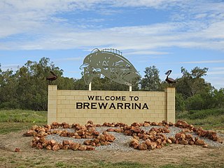
Brewarrina is a town in north-west New South Wales, Australia on the banks of the Barwon River in Brewarrina Shire. The name Brewarrina is derived from 'burru waranha', a Weilwan name for a species of Acacia, Cassia tree, "Acacia clumps", "a native standing" or "place where wild gooseberry grows". It is 96 kilometres (60 mi) east of Bourke and west of Walgett on the Kamilaroi Highway, and 787 km from Sydney. The population of Brewarrina in 2016 was 1,143. Other towns and villages in the Brewarrina district include: Goodooga, Gongolgon, Weilmoringle and Angledool.

<span class="mw-page-title-main">Kendall, New South Wales</span> Town in New South Wales, Australia

Kendall is a town on the Mid North Coast of New South Wales, Australia.

<span class="mw-page-title-main">Warren Shire</span> Local government area in New South Wales, Australia

Warren Shire is a local government area in the Orana region of New South Wales, Australia. The Shire is located adjacent to the Macquarie River and the Mitchell and Oxley Highways. The use of the area is mainly for wool and cotton growing.

<span class="mw-page-title-main">Bourke Shire</span> Local government area in New South Wales, Australia

Bourke Shire is a local government area in the Orana region of New South Wales, Australia. The Shire is located adjacent to the Darling River, which is known as the Barwon River upstream from Bourke; and located adjacent to the Mitchell Highway. The northern boundary of the Shire is located adjacent to the border between New South Wales and Queensland. The shire is a wool and beef producing area.

<span class="mw-page-title-main">Wakool</span> Town in New South Wales, Australia

Wakool is a town in the western Murray region of New South Wales, Australia. Wakool is in the Murray River Council local government area, 791 kilometres (492 mi) south west of the state capital, Sydney and 336 kilometres (209 mi) north-west of Melbourne. At the 2016 census, Wakool had a population of 297.

<span class="mw-page-title-main">Carual, New South Wales</span> Suburb of Warren Shire, New South Wales, Australia

Carual, New South Wales also known as Carval is a civil parish and rural locality of New South Wales located at 31°37'54.0"S 147°44'04.0"E.

<span class="mw-page-title-main">Egelabra, New South Wales</span> Place in New South Wales, Australia

Egelabra, New South Wales is a civil parish and rural locality of New South Wales located at 31°47′54″S 147°50′04″E.

<span class="mw-page-title-main">Ganalgang, New South Wales</span> Place in New South Wales, Australia

Ganalgang, New South Wales is a civil parish and rural locality of New South Wales located at 31°49′54″S 147°56′04″E.

Killendoon is a rural locality of Warren Shire and is in the civil parish of County of Ewenmar. Killendoon is on the Ewenma Creek Macquarie River outside Warren, New South Wales.

Driel is a rural locality of Warren Shire 31°39′54″S 147°56′04″E a few miles north of Warren, New South Wales Driel is also a civil Parish]] of Ewenmar County, a cadastral division of New South Wales.

References

  1. 1 2 3 Australian Bureau of Statistics (27 June 2017). "Warren (Urban Centre/Locality)". 2016 Census QuickStats. Retrieved 1 September 2019. OOjs UI icon edit-ltr-progressive.svg CC-BY icon.svg Material was copied from this source, which is available under a Creative Commons Attribution 4.0 International License.
  2. "New South Wales Forecast Area Map". www.bom.gov.au. Retrieved 29 March 2016.
  3. "Warren - New South Wales - Australia - Travel - smh.com.au". www.smh.com.au. Retrieved 29 March 2016.
  4. "Statistics by Catalogue Number". Australian Bureau of Statistics. Retrieved 22 January 2024.
  5. "Search Census data". Australian Bureau of Statistics. Retrieved 22 January 2024.
  6. "Warren (Auscott), NSW Climate (1968–1985 normals and extremes)". Australian Bureau of Meteorology . Retrieved 15 May 2022.
  7. Far West Academy of Sport
  8. "ACTU President - Australian Council of Trade Unions". Australian Council of Trade Unions. Retrieved 18 April 2008.

Commons-logo.svg Media related to Warren, New South Wales at Wikimedia Commons