Washington Column

Last updated
Washington Column
Reflection of trees and Washington Column in lake, Yosemite National Park, Calif. LCCN95514093.tif
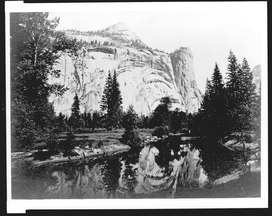
Reflection of trees and Washington Column in lake. North Dome is above, left of Washington Column
Highest point
Elevation 6,347 ft (1,935 m)  NAVD 88 [1]
Coordinates 37°45′00″N119°33′36″W / 37.75000°N 119.56°W / 37.75000; -119.56 Coordinates: 37°45′00″N119°33′36″W / 37.75000°N 119.56°W / 37.75000; -119.56 [2]
Geography
Location Yosemite National Park, Mariposa County, California, U.S.
Parent range Sierra Nevada
Topo map USGS Washington Column
Geology
Age of rock Cretaceous
Mountain type Granite dome
Climbing
Easiest route Trail hike from the north, class 1 [3]

Washington Column is a roughly 1800-foot high rock formation, arising from Yosemite Valley. It is east of the Royal Arches, behind the Ahwahnee Hotel. North Dome is above it. Washington Column can be viewed from many points in Yosemite Valley, [4] including the trail to Mirror Lake. [5]

Washington Column has numerous rock climbing routes. [4]

Related Research Articles

Yosemite National Park National park in California, United States

Yosemite National Park is an American national park in the western Sierra Nevada of Central California, bounded on the southeast by Sierra National Forest and on the northwest by Stanislaus National Forest. The park is managed by the National Park Service and covers an area of 748,436 acres and sits in four counties: centered in Tuolumne and Mariposa, extending north and east to Mono and south to Madera County. Designated a World Heritage Site in 1984, Yosemite is internationally recognized for its granite cliffs, waterfalls, clear streams, giant sequoia groves, lakes, mountains, meadows, glaciers, and biological diversity. Almost 95% of the park is designated wilderness.

Yosemite Valley

Yosemite Valley is a glacial valley in Yosemite National Park in the western Sierra Nevada mountains of Central California. The valley is about 7.5 miles (12 km) long and approximately 3000–3500 feet deep, surrounded by high granite summits such as Half Dome and El Capitan, and densely forested with pines. The valley is drained by the Merced River, and a multitude of streams and waterfalls flow into it, including Tenaya, Illilouette, Yosemite and Bridalveil Creeks. Yosemite Falls is the highest waterfall in North America and is a big attraction especially in the spring, when the water flow is at its peak. The valley is renowned for its natural environment and is regarded as the centerpiece of Yosemite National Park, attracting visitors from around the world.

Half Dome Granite dome in Yosemite National Park, California

Half Dome is a granite dome at the eastern end of Yosemite Valley in Yosemite National Park, California. It is a well-known rock formation in the park, named for its distinct shape. One side is a sheer face while the other three sides are smooth and round, making it appear like a dome cut in half. The granite crest rises more than 4,737 ft (1,444 m) above the valley floor.

Tuolumne Meadows United States historic place

Tuolumne Meadows is a gentle, dome-studded, sub-alpine meadow area along the Tuolumne River in the eastern section of Yosemite National Park in the United States. Its approximate location is 37°52.5′N119°21′W. Its approximate elevation is 8,619 feet (2,627 m). The term Tuolumne Meadows is also often used to describe a large portion of the Yosemite high country around the meadows, especially in context of rock climbing.

Geology of the Yosemite area

The exposed geology of the Yosemite area includes primarily granitic rocks with some older metamorphic rock. The first rocks were laid down in Precambrian times, when the area around Yosemite National Park was on the edge of a very young North American continent. The sediment that formed the area first settled in the waters of a shallow sea, and compressive forces from a subduction zone in the mid-Paleozoic fused the seabed rocks and sediments, appending them to the continent. Heat generated from the subduction created island arcs of volcanoes that were also thrust into the area of the park. In time, the igneous and sedimentary rocks of the area were later heavily metamorphosed.

Mist Trail

The Mist Trail is one of the most popular short hikes in Yosemite National Park, California, USA. The steep hike follows the Merced River, starting at Happy Isles in Yosemite Valley, past Vernal Fall and Emerald Pool, to Nevada Fall.

Lembert Dome

Lembert Dome is a granite dome rock formation in Yosemite National Park in the US state of California. The dome soars 800 feet (240 m) above Tuolumne Meadows and the Tuolumne River and can be hiked starting at the Tioga Road in the heart of Tuolumne Meadows, 8 miles (13 km) west of the Tioga Pass Entrance to Yosemite National Park. The landform is an example of a rôche moutonnée with clear lee and stoss slopes.

Steve Roper is a noted climber and historian of the Sierra Nevada in the United States. He along with Allen Steck are the founding editors of the Sierra Club journal Ascent.

North Dome

North Dome is a granite dome in Yosemite National Park, California. It is the southernmost summit of Indian Ridge, 0.6 miles (1.0 km) north of Washington Column and the Royal Arches on the northeastern wall of Yosemite Valley. It can be reached by trail from the Tioga Pass Road, or by going up the Yosemite Falls trail and heading east. It can also be reached from Mirror Lakes by the Snow Creek Falls trail going north around Indian Rock and then south again on the Tioga Pass Road trail. The South Face is precipitous.

Royal Robbins

Royal Robbins was one of the pioneers of American rock climbing. After learning to climb at Tahquitz Rock, he went on to make first ascents of many big wall routes in Yosemite. As an early proponent of boltless, pitonless clean climbing, he, along with Yvon Chouinard, was instrumental in changing the climbing culture of the late 1960s and early 1970s by encouraging the use and preservation of the natural features of the rock. He went on to become a well-known kayaker.

Warren Harding (climber)

Warren Harding was one of the most accomplished and influential American rock climbers of the 1950s to 1970s. He was the leader of the first team to climb El Capitan, Yosemite Valley, in 1958. The route they climbed, known as The Nose, ascends 2,900 feet (880 m) up the central buttress of what is one of the largest granite monoliths in the world. Harding climbed many other first ascents in Yosemite, some 28 in all, as well as making the first true big-wall ascents in the Sierra Nevada range of California.

Jim Bridwell

Jim Bridwell was an American rock climber and mountaineer, active since 1965, especially in Yosemite Valley, but also in Patagonia and Alaska. He is noted for pushing the standards of both free climbing and big-wall climbing, and later alpine climbing. He wrote numerous articles on climbing for leading sport publications. He was an apprentice to Royal Robbins and Warren Harding (climber). He was the unofficial leader of the Stonemasters.

George G. Anderson is best known for making the first ascent to the summit of Half Dome in Yosemite National Park in California, United States on October 12, 1875. During the climb, he drilled the holes which, after 1919, came to house the cables of the popular route up Half Dome. A pioneer without the benefit of modern climbing gear or techniques, Anderson worked barefoot, and placed iron spikes drilled into the rock for protection. The ascent took him days on end. His one-room log cabin, originally located at what is now Foresta just west of Yosemite Valley, was moved to the Pioneer Yosemite History Center in Wawona where it continues to be preserved.

Geography of the Yosemite area

Yosemite National Park is located in the central Sierra Nevada of California. Three wilderness areas are adjacent to Yosemite: the Ansel Adams Wilderness to the southeast, the Hoover Wilderness to the northeast, and the Emigrant Wilderness to the north.

Fairview Dome

Fairview Dome is a prominent granite dome in Yosemite National Park, located 1.8 miles (2.9 km) north of Cathedral Peak and 4 miles (6.4 km) west of Tuolumne Meadows. Near Fairview Dome is Marmot Dome, linked by an area called Razor Back. Northwest is Hammer Dome.

<i>Royal Arches Route</i>

The Royal Arches Route is a technical climbing route in California's Yosemite Valley on the Royal Arches wall. The route is recognized in the historic climbing text Fifty Classic Climbs of North America. The route was first climbed Oct. 1936 by Ken Adam, Morgan Harris, K. Kenneth Davis. The route is moderate in difficulty and is frequently climbed. The first 4 pitches are along a west facing dihedral. At Pitch 5, the route turns north and ascends the main face along crack systems. Pitch 10 can be free climbed at 5.10b however, most climbers use a fixed rope to pendulum to a long ledge. At the end of Pitch 15, begins the bolted rappel route. It is 18 rappels to the Valley floor. Some climbers prefer to continue to "The Jungle" at the end of Pitch 16. Beyond The Jungle is a 5.4 slab and 4th Class scrambling to the Valley Rim. The descent is usually accomplished by traversing northeast to Washington Column and descending the exposed North Dome Gully.

Royal Arches (Yosemite)

The Royal Arches refers to a cliff containing natural occurring granite exfoliation arches, located below North Dome and rising above Yosemite Valley, in Yosemite National Park, California..

Chuck Pratt

Charles Marshall Pratt was an American rock climber known for big wall climbing first ascents in Yosemite Valley. He was also a long-time climbing instructor and mountain guide with Exum Mountain Guides in the Grand Tetons.

Jerry Gallwas

Jerry Gallwas is an American rock climber active in the 1950s during the dawn of the Golden Age of Yosemite Rock Climbing. He achieved a number of pioneering first ascents including sandstone spires in the American Southwest, and the first ascent of the Northwest Face of Half Dome with Royal Robbins and Mike Sherrick in 1957. Gallwas made his own heat-treated chrome-molybdenum steel alloy pitons, which contributed to the success of the climb.

Hiking, rock climbing, and mountain climbing around Tuolumne Meadows

Hiking, rock climbing, and mountain climbing around Tuolumne Meadows in Yosemite National Park has many options.

References

  1. "Washington Column, California". SummitPost.org.
  2. "North Dome". Geographic Names Information System . United States Geological Survey.
  3. Roper, Steve (1976). The Climber's Guide to the High Sierra. San Francisco: Sierra Club Books. p. 239. ISBN   9780871561473.
  4. 1 2 Peer, Craig. "Washington Column - Yosemite Valley".
  5. "Yosemite national Park California".