The Indian Territory and the Indian Territories are terms that generally described an evolving land area set aside by the United States government for the relocation of Native Americans who held original Indian title to their land as a sovereign independent state. The tribes ceded land they occupied in exchange for land grants in 1803. The concept of an Indian Territory was an outcome of the U.S. federal government's 18th- and 19th-century policy of Indian removal. After the American Civil War (1861–1865), the policy of the U.S. government was one of assimilation.

Osage County is the largest county by area in the U.S. state of Oklahoma. Created in 1907 when Oklahoma was admitted as a state, the county is named for and is home to the federally recognized Osage Nation. The county is coextensive with the Osage Nation Reservation, established by treaty in the 19th century when the Osage relocated there from Kansas. The county seat is in Pawhuska, one of the first three towns established in the county. The total population of the county as of 2020 was 45,818.

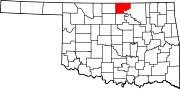
Kay County is a county located in the U.S. state of Oklahoma. As of the 2020 census, its population was 43,700. Its county seat is Newkirk, and the largest city is Ponca City.

Kaw City is a city in eastern Kay County, Oklahoma, United States. The population was 375 at the 2010 census, an increase of 1 percent from the figure of 372 in 2000. Kaw City was named for the Kanza Indians, called the Kaw by locals.
Newkirk is a city and county seat of Kay County, Oklahoma, United States. The population was 2,172 at the 2020 census.

The Kaw Nation is a federally recognized Native American tribe in Oklahoma and parts of Kansas. It comes from the central Midwestern United States. It has also been called the "People of the South wind", "People of water", Kansa, Kaza, Konza, Conza, Quans, Kosa, and Kasa. Their tribal language is Kansa, classified as a Siouan language.

The Oklahoma Indian Welfare Act of 1936 is a United States federal law that extended the 1934 Wheeler-Howard or Indian Reorganization Act to include those tribes within the boundaries of the state of Oklahoma. The purpose of these acts were to rebuild Indian tribal societies, return land to the tribes, enable tribes to rebuild their governments, and emphasize Native culture. These Acts were developed by John Collier, Commissioner of Indian Affairs from 1933 to 1945, who wanted to change federal Indian policy from the "twin evils" of allotment and assimilation, and support Indian self-government.

The Cherokee Outlet, or Cherokee Strip, was located in what is now the state of Oklahoma in the United States. It was a 60-mile-wide (97 km) parcel of land south of the Oklahoma-Kansas border between 96 and 100°W. The Cherokee Outlet was created in 1836. The United States forced the Cherokee Nation of Indians to cede to the United States all lands east of the Mississippi River in exchange for a reservation and an "outlet" in Indian Territory. At the time of its creation, the Cherokee Outlet was about 225 miles (360 km) long. The cities of Enid, Woodward, Ponca City, and Perry were later founded within the boundaries of what had been the Cherokee Outlet.

The Ponca are a Midwestern Native American tribe of the Dhegihan branch of the Siouan language group. There are two federally recognized Ponca tribes: the Ponca Tribe of Nebraska and the Ponca Tribe of Indians of Oklahoma. Their oral history states they originated as a tribe east of the Mississippi River in the Ohio River valley area and migrated west for game and as a result of Iroquois wars.
The Osage Nation is a Midwestern Native American tribe of the Great Plains. The tribe developed in the Ohio and Mississippi river valleys around 700 BC along with other groups of its language family. They migrated west after the 17th century, settling near the confluence of the Missouri and Mississippi rivers, as a result of Iroquois invading the Ohio Valley in a search for new hunting grounds.

The Joseph H. Williams Tallgrass Prairie Preserve, in Osage County, Oklahoma near Foraker, Oklahoma, is the largest protected tract of tallgrass prairie in the world. Managed by The Nature Conservancy, the preserve contains 39,650 acres (160 km2) owned by the Conservancy and another 6,000 acres (24 km2) leased in what was the original tallgrass region of the Great Plains that stretched from Texas to Manitoba.
Black Bob was a Native American Shawnee Chief. His band was a part of the Hathawekela division of the Shawnee. He was known for being one of the last Shawnee to resist leaving for the Indian Territory, and for keeping his band together until his death, holding their lands in common, as they moved between Missouri, Arkansas, and the Black Bob Reservation in Kansas.
The Curtis Act of 1898 was an amendment to the United States Dawes Act; it resulted in the break-up of tribal governments and communal lands in Indian Territory of the Five Civilized Tribes of Indian Territory: the Choctaw, Chickasaw, Muscogee (Creek), Cherokee, and Seminole. These tribes had been previously exempt from the 1887 General Allotment Act because of the terms of their treaties. In total, the tribes immediately lost control of about 90 million acres of their communal lands; they lost more in subsequent years.
A Half-Breed Tract was a segment of land designated in the western states by the United States government in the 19th century specifically for Métis of American Indian and European or European-American ancestry, at the time commonly known as half-breeds. The government set aside such tracts in several parts of the Midwestern prairie region, including in Iowa Territory, Nebraska Territory, Kansas Territory, Minnesota Territory, and Wisconsin Territory.

Cheyenne and Arapaho Indian Reservation were the lands granted the Southern Cheyenne and the Southern Arapaho by the United States under the Medicine Lodge Treaty signed in 1867. The tribes never lived on the land described in the treaty and did not want to.

White Plume, also known as Nom-pa-wa-rah, Manshenscaw, and Monchousia, was a chief of the Kaw Indigenous American tribe. He signed a treaty in 1825 ceding millions of acres of Kaw land to the United States. Most present-day members of the Kaw Nation of Oklahoma trace their lineage back to him. He was the great-great-grandfather of Charles Curtis, 31st Vice President of the United States.

Joseph James is the name of two Kansa-Osage-French interpreters on the Kansas and Indian Territory frontier in the 19th century. Both were usually called "Joe Jim" or "Jojim".

The Cherokee Commission, was a three-person bi-partisan body created by President Benjamin Harrison to operate under the direction of the Secretary of the Interior, as empowered by Section 14 of the Indian Appropriations Act of March 2, 1889. Section 15 of the same Act empowered the President to open land for settlement. The Commission's purpose was to legally acquire land occupied by the Cherokee Nation and other tribes in the Oklahoma Territory for non-indigenous homestead acreage.