Watts Point volcanic centre

Last updated
Watts Point volcanic centre
Canada British Columbia relief location map.jpg
Red triangle with thick white border.svg
Watts Point volcanic centre
Location in British Columbia
Highest point
Elevation ~ 240 m (800 ft)
Coordinates 49°39′10″N123°12′30″W / 49.65278°N 123.20833°W / 49.65278; -123.20833 Coordinates: 49°39′10″N123°12′30″W / 49.65278°N 123.20833°W / 49.65278; -123.20833
Geography
Location British Columbia, Canada
Parent range Britannia Range (North Shore Mountains)
Topo map NTS 92G/11 Squamish
Geology
Age of rock ~ 90,000–130,000 years
Mountain type Subglacial mound
Volcanic arc/belt Canadian Cascade Arc
Garibaldi Volcanic Belt
Last eruption ~ 90,000 years

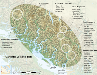
The Watts Point volcanic centre is a small outcrop of Pleistocene age volcanic rock at Watts Point in British Columbia, Canada, about 10 kilometres (6 mi) south of Squamish and 40 kilometres (25 mi) north of Vancouver, and just north of Britannia Beach. It is the southernmost volcanic zone in the Squamish volcanic field and of the Garibaldi segment of the Cascade Volcanic Arc. The latest research indicates that it is most likely a subglacial mound. It comprises a continuous mass of sparsely porphyritic highly jointed dacitic lava overlying the mid-Cretaceous Coast Plutonic Complex and overlain locally by clay and of glacial till.

Outcrop visible exposure of bedrock or ancient superficial deposits on the surface of the Earth

An outcrop or rocky outcrop is a visible exposure of bedrock or ancient superficial deposits on the surface of the Earth.

The Pleistocene is the geological epoch which lasted from about 2,588,000 to 11,700 years ago, spanning the world's most recent period of repeated glaciations. The end of the Pleistocene corresponds with the end of the last glacial period and also with the end of the Paleolithic age used in archaeology.

Volcanic rock rocks composing or associated with volcanoes, volcanic activity or volcanism

Volcanic rock is a rock formed from magma erupted from a volcano. In other words, it differs from other igneous rock by being of volcanic origin. Like all rock types, the concept of volcanic rock is artificial, and in nature volcanic rocks grade into hypabyssal and metamorphic rocks and constitute an important element of some sediments and sedimentary rocks. For these reasons, in geology, volcanics and shallow hypabyssal rocks are not always treated as distinct. In the context of Precambrian shield geology, the term "volcanic" is often applied to what are strictly metavolcanic rocks. Volcanic rocks and sediment that form from magma erupted into the air are called "volcaniclastics," and these are technically sedimentary rocks.

Contents

The volcanic outcrop at Watts Point extends from below the present sea level up the side of a steep slope over 240 metres (800 ft). The outcrop is less than 1 kilometre (0.6 mi) long, with an area of about 0.4 square kilometres (0.2 sq mi) and an eruptive volume of roughly 0.02 cubic kilometres (0.0048 cu mi). The location is heavily forested, and the BC Rail mainline passes through the lower portion of the outcrop about 40 m (130 ft) above sea level. Two railroad track ballast quarries, one near the middle and the other near the upper edge, provide the best exposure of the interior of the lava mass. BC Highway 99 climbs over the eastern shoulder of the complex before descending to the area of the Stawamus Chief and Murrin Park, south southeast of Squamish.

Sea level Average level for the surface of the ocean at any given geographical position on the planetary surface

Mean sea level (MSL) is an average level of the surface of one or more of Earth's oceans from which heights such as elevation may be measured. MSL is a type of vertical datum – a standardised geodetic datum – that is used, for example, as a chart datum in cartography and marine navigation, or, in aviation, as the standard sea level at which atmospheric pressure is measured to calibrate altitude and, consequently, aircraft flight levels. A common and relatively straightforward mean sea-level standard is the midpoint between a mean low and mean high tide at a particular location.

BC Rail transport company

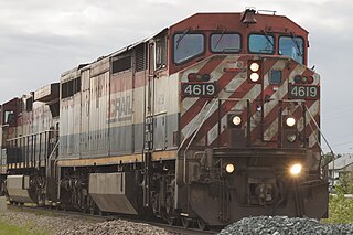
BC Rail, known as the British Columbia Railway between 1972 and 1984 and as the Pacific Great Eastern Railway (PGE) before 1972, was a railway that operated in the Canadian province of British Columbia between 1912 and 2004. It was a class II regional railway and the third-largest in Canada, operating 2,320 km (1,440 mi) of mainline track. Its operations were owned by the public as a crown corporation from 1918 until 2004, when the provincial government leased operations for 999 years to CN. The track and other assets, including a marine division and stevedoring subsidiary as well as large tracts of real estate, remain under public ownership. 40 km of track serving the Roberts Bank Superport that were scheduled to be sold to OmniTRAX remain under BC Rail management due to that sale being cancelled because of the transaction being tainted by an influence-peddling and bribery scandal resulting in convictions in 2010. The provincial government, which promised when originally elected never to sell the railway, has announced that the crown corporation and its remaining operations and assets would be "wound down" and taken over by various departments of the Ministry of Transportation The details of the sale/lease to CN, which are related to the OmniTRAX affair, have become the subject of protracted public inquiry as part of the proceedings of the trial surrounding a scandal known as the British Columbia Legislature Raids Affair, or "Railgate". Government leaders and civil servants involved with the arrangements to CN have refused to comment on the deal because the matter "is before the courts".

Track ballast trackbed upon which railroad ties are laid

Track ballast forms the trackbed upon which railroad ties (sleepers) are laid. It is packed between, below, and around the ties. It is used to bear the load from the railroad ties, to facilitate drainage of water, and also to keep down vegetation that might interfere with the track structure. This also serves to hold the track in place as the trains roll by. It is typically made of crushed stone, although ballast has sometimes consisted of other, less suitable materials, for example burnt clay. The term "ballast" comes from a nautical term for the stones used to stabilize a ship.

See also

Cascade Volcanoes Chain of stratovolcanoes in western North America

The Cascade Volcanoes are a number of volcanoes in a volcanic arc in western North America, extending from southwestern British Columbia through Washington and Oregon to Northern California, a distance of well over 700 miles (1,100 km). The arc formed due to subduction along the Cascadia subduction zone. Although taking its name from the Cascade Range, this term is a geologic grouping rather than a geographic one, and the Cascade Volcanoes extend north into the Coast Mountains, past the Fraser River which is the northward limit of the Cascade Range proper.

Garibaldi Volcanic Belt mountain in Canada

The Garibaldi Volcanic Belt is a northwest-southeast trending volcanic chain in the Pacific Ranges of the Coast Mountains that extends from Watts Point in the south to the Ha-Iltzuk Icefield in the north. This chain of volcanoes is located in southwestern British Columbia, Canada. It forms the northernmost segment of the Cascade Volcanic Arc, which includes Mount St. Helens and Mount Baker. Most volcanoes of the Garibaldi chain are dormant stratovolcanoes and subglacial volcanoes that have been eroded by glacial ice. Less common volcanic landforms include cinder cones, volcanic plugs, lava domes and calderas. These diverse formations were created by different styles of volcanic activity, including Peléan and Plinian eruptions.

Geology of the Pacific Northwest geology of Oregon and Washington (United States) and British Columbia (Canada)

The geology of the Pacific Northwest includes the composition, structure, physical properties and the processes that shape the Pacific Northwest region of the United States and Canada. The geology of the region is responsible for some of area's scenic beauty as well as some of its hazards, such as volcanoes, earthquakes, and landslides.

Related Research Articles

Mount Garibaldi mountain in Canada

Mount Garibaldi is a potentially active stratovolcano in the Sea to Sky Country of British Columbia, 80 km (50 mi) north of Vancouver, British Columbia, Canada. Located in the southernmost Coast Mountains, it is one of the most recognized peaks in the South Coast region, as well as British Columbia's best known volcano. It lies within the Garibaldi Ranges of the Pacific Ranges.

The Black Tusk mountain in Canada

The Black Tusk is a stratovolcano and a pinnacle of volcanic rock in Garibaldi Provincial Park of British Columbia, Canada. At 2,319 m (7,608 ft) above sea level, the upper spire is visible from a great distance in all directions. It is particularly noticeable from the Sea-to-Sky Highway just south of Whistler, British Columbia. Distinctive and immediately identifiable, The Black Tusk is among the best known mountains in the Garibaldi Ranges of the Coast Mountains. The volcano is part of the Garibaldi Volcanic Belt which is a segment of the Canadian Cascade Arc, but it is not within the geographic boundary of the Cascade Range.

Mount Meager massif mountain

The Mount Meager massif is a group of volcanic peaks in the Pacific Ranges of the Coast Mountains in southwestern British Columbia, Canada. Part of the Cascade Volcanic Arc of western North America, it is located 150 km (93 mi) north of Vancouver at the northern end of the Pemberton Valley and reaches a maximum elevation of 2,680 m (8,790 ft). The massif is capped by several eroded volcanic edifices, including lava domes, volcanic plugs and overlapping piles of lava flows; these form at least six major summits including Mount Meager which is the second highest of the massif.

Mount Price (British Columbia) volcano in British Columbia, Canada

Mount Price is a small stratovolcano in the Garibaldi Ranges of the Pacific Ranges in southwestern British Columbia, Canada. It is located 10 km (6.2 mi) southeast of the abandoned settlement of Garibaldi above the eastern flank of the Cheakamus River valley. With a summit elevation of 2,052 m (6,732 ft) and a topographic prominence of 402 m (1,319 ft), it rises above the surrounding landscape on the western shore of Garibaldi Lake. A large provincial park surrounds Mount Price and other volcanoes in its vicinity.

Mount Fee mountain

Mount Fee is a volcanic peak in the Pacific Ranges of the Coast Mountains in southwestern British Columbia, Canada. It is located 13 km (8.1 mi) south of Callaghan Lake and 21 km (13 mi) west of the resort town of Whistler. With a summit elevation of 2,162 m (7,093 ft) and a topographic prominence of 312 m (1,024 ft), it rises above the surrounding rugged landscape on an alpine mountain ridge. This mountain ridge represents the base of a north-south trending volcanic field which Mount Fee occupies.

The Table mountain in Canada

The Table, sometimes called Table Mountain, is a 2,021-metre (6,631 ft) high flow-dominated andesite tuya located 4 kilometres (2 mi) south of Garibaldi Lake, 15 kilometres (9 mi) northeast of Cheekye and 5 kilometres (3 mi) north of Mount Garibaldi, British Columbia, Canada. It rises over 530 metres (1,740 ft) above the surface of Garibaldi Lake, which lies less than 1 kilometre (1 mi) to the north.

Mount Silverthrone mountain

Mount Silverthrone, officially named Silverthrone Mountain, is a mountain in the Pacific Ranges of the Coast Mountains of British Columbia, Canada, located over 320 km (200 mi) northwest of the city of Vancouver and about 50 km (30 mi) west of Mount Waddington, British Columbia, Canada. It is the highest peak in the Ha-Iltzuk Icefield, which is the largest icefield in the Coast Mountains south of the Alaska Panhandle.

Garibaldi Lake Canadian lake

Garibaldi Lake is a turquoise-coloured alpine lake in British Columbia, Canada, located 37 km (23 mi) north of Squamish and 19 km (12 mi) south of Whistler. The lake lies within Garibaldi Provincial Park, which features mountains, glaciers, trails, forests, flowers, meadows, waterfalls. The park is a wildlife protected area.

Volcanology of Canada

Volcanology of Canada includes lava flows, lava plateaus, lava domes, cinder cones, stratovolcanoes, shield volcanoes, submarine volcanoes, calderas, diatremes, and maars, along with examples of more less common volcanic forms such as tuyas and subglacial mounds. It has a very complex volcanological history spanning from the Precambrian eon at least 3.11 billion years ago when this part of the North American continent began to form.

The Castle (volcano) volcano

The Castle is a lava spine located west of Squamish in southwestern British Columbia, Canada. Volcanism at The Castle is controlled by north-south structures and there are no hot springs known in the area. It forms part of the Monmouth Creek complex and is part of the Garibaldi Volcanic Belt which is a segment of the Cascade Volcanic Arc.

The Barrier

The Barrier is a lava dam retaining the Garibaldi Lake system in southwestern British Columbia, Canada. It is over 300 m (980 ft) thick and about 2.4 km (1.5 mi) long where it impounds the lake.

Silverthrone Caldera Stratovolcano in Canada

The Silverthrone Caldera is a potentially active caldera complex in southwestern British Columbia, Canada, located over 350 kilometres (220 mi) northwest of the city of Vancouver and about 50 kilometres (31 mi) west of Mount Waddington in the Pacific Ranges of the Coast Mountains. The caldera is one of the largest of the few calderas in western Canada, measuring about 30 kilometres (19 mi) long (north-south) and 20 kilometres (12 mi) wide (east-west). Mount Silverthrone, an eroded lava dome on the caldera's northern flank that is 2,864 metres (9,396 ft) high may be the highest volcano in Canada.

Mount Edziza volcanic complex mountain in Canada

The Mount Edziza volcanic complex is a large and potentially active north-south trending complex volcano in Stikine Country, northwestern British Columbia, Canada, located 38 kilometres (24 mi) southeast of the small community of Telegraph Creek. It occupies the southeastern portion of the Tahltan Highland, an upland area of plateau and lower mountain ranges, lying east of the Boundary Ranges and south of the Inklin River, which is the east fork of the Taku River. As a volcanic complex, it consists of many types of volcanoes, including shield volcanoes, calderas, lava domes, stratovolcanoes, and cinder cones.

Volcanic history of the Northern Cordilleran Volcanic Province

The volcanic history of the Northern Cordilleran Volcanic Province presents a record of volcanic activity in northwestern British Columbia, central Yukon and the U.S. state of easternmost Alaska. The volcanic activity lies in the northern part of the Western Cordillera of the Pacific Northwest region of North America. Extensional cracking of the North American Plate in this part of North America has existed for millions of years. Continuation of this continental rifting has fed scores of volcanoes throughout the Northern Cordilleran Volcanic Province over at least the past 20 million years and occasionally continued into geologically recent times.

Canadian Cascade Arc

The Canadian Cascade Arc, also called the Canadian Cascades, is the Canadian segment of the North American Cascade Volcanic Arc. Located entirely within the Canadian province of British Columbia, it extends from the Cascade Mountains in the south to the Coast Mountains in the north. Specifically, the southern end of the Canadian Cascades begin at the Canada–United States border. However, the specific boundaries of the northern end are not precisely known and the geology in this part of the volcanic arc is poorly understood. It is widely accepted by geologists that the Canadian Cascade Arc extends through the Pacific Ranges of the Coast Mountains. However, others have expressed concern that the volcanic arc possibly extends further north into the Kitimat Ranges, another subdivision of the Coast Mountains, and even as far north as Haida Gwaii.

Monmouth Creek complex mountain in Canada

The Monmouth Creek complex is a volcanic complex in southwestern British Columbia, Canada, located 4 km (2.5 mi) southwest of the community of Squamish on the west side of the Squamish River mouth. It lies in the southern Pacific Ranges of the Coast Mountains and is part of the Squamish volcanic field in the southern Garibaldi Volcanic Belt, which represents the northernmost extension of the Cascade Volcanic Arc.

Mount Cayley volcanic field A volcanic zone on the South Coast of British Columbia in Canada

The Mount Cayley volcanic field is a remote volcanic zone on the South Coast of British Columbia, Canada, stretching 31 km (19 mi) from the Pemberton Icefield to the Squamish River. It forms a segment of the Garibaldi Volcanic Belt, the Canadian portion of the Cascade Volcanic Arc, which extends from Northern California to southwestern British Columbia. Most of the Cayley volcanoes were formed during periods of volcanism under sheets of glacial ice throughout the last glacial period. These subglacial eruptions formed steep, flat-topped volcanoes and subglacial lava domes, most of which have been entirely exposed by deglaciation. However, at least two volcanoes predate the last glacial period and both are highly eroded. The field gets its name from Mount Cayley, the largest and most persistent volcano, located at the southern end of the Powder Mountain Icefield. This icefield covers much of the central portion of the volcanic field and is one of the several glacial fields in the Pacific Ranges of the Coast Mountains.

Squamish volcanic field

The Squamish volcanic field is a small north-south trending volcanic field on the South Coast of British Columbia, Canada. It extends for only about 3 km (1.9 mi) from the eastern side of Howe Sound northeast of Britannia Beach to the heavily forested slope on the western side of the Squamish River mouth. It forms the southernmost end of the Garibaldi Volcanic Belt, which comprises part of the Canadian Cascade Arc. Its volcanoes are relatively minor to the more voluminous stratovolcanoes found throughout the Garibaldi Belt and are composed of dacite and lesser basaltic andesite. The field gets its name from the nearby community of Squamish at the north end of Howe Sound on the Sea to Sky Highway.

Mount Cayley massif mountain in Canada

The Mount Cayley massif is a group of mountains in the Pacific Ranges of southwestern British Columbia, Canada. Located 45 km (28 mi) north of Squamish and 24 km (15 mi) west of Whistler, the massif resides on the edge of the Powder Mountain Icefield. It consists of an eroded but potentially active stratovolcano that towers over the Cheakamus and Squamish river valleys. All major summits have elevations greater than 2,000 m (6,600 ft), Mount Cayley being the highest at 2,385 m (7,825 ft). The surrounding area has been inhabited by indigenous peoples for more than 7,000 years while geothermal exploration has taken place there for the last four decades.

References

Geological Survey of Canada branch of Natural Resources Canada

The Geological Survey of Canada is a Canadian federal government agency responsible for performing geological surveys of the country, developing Canada's natural resources and protecting the environment. A branch of the Earth Sciences Sector of Natural Resources Canada, the GSC is the country's oldest scientific agency and was one of its first government organizations.