Atwell Peak

Last updated
Atwell Peak
Atwell Peak.jpg
Atwell Peak
Highest point
Elevation 2,655 m (8,711 ft)
Prominence 125 m (410 ft)
Listing List of volcanoes in Canada
Coordinates 49°50′28″N123°00′33″W / 49.84111°N 123.00917°W / 49.84111; -123.00917
Geography
Canada British Columbia relief location map.jpg
Red triangle with thick white border.svg
Atwell Peak
Location in SW British Columbia
Location British Columbia, Canada
District New Westminster Land District
Parent range Garibaldi Ranges
Topo map NTS   92G14 Cheakamus River
Geology
Age of rock Pleistocene
Mountain type Lava dome
Volcanic arc/belt Canadian Cascade Arc
Last eruption Pleistocene
Climbing
First ascent 1911 A. Armistead; B. Darling; J. Davies; F. Hewton; A. Morkill
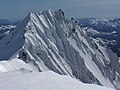
Atwell Peak is a dramatic pyramid shaped volcanic peak located at the southern edge of Mount Garibaldi, British Columbia, Canada. Atwell Peak was the source of many pyroclastic flows during Garibaldi's development. [1] Frequent landslides on its west face drops steeply into the Cheekye River. Atwell Peak is often mistakenly called Mount Garibaldi when viewed from Squamish, since the main peak is hidden. The peak is usually climbed during winter or early spring when the rock is frozen because it is very loose and rotten. Atwell Peak contains three ridges, the north, east, and south. The two most visible routes are the north and south ridges.

Contents

Atwell Peak is part of the Garibaldi Massif which is an eroded stratovolcano formed during the last ice age. The volcano is also part of the Garibaldi Volcanic Belt which is a segment of the Canadian Cascade Arc, but it is not within the geographic boundary of the Cascade Range. It is located in the Garibaldi Ranges of the Pacific Ranges.

Ridges

Atwell from Garibaldi Atwell Peak1.jpg
Atwell from Garibaldi

Atwell Peak consists of three ridges, the north, east, and south. The east ridge connects with the north ridge about 100 horizontal metres north of the summit. All ridges, with the possible exception of the upper east ridge, are sharp and heavily corniced in winter and spring. The north ridge is the shortest climbing route. Several gullies on the southeast face offer moderate routes that eventually join one of the three ridges. The northeast face is the shortest of the peak's faces but has many bergschrunds.

Glaciers and icefield

To the east of Atwell Peak lies the Garibaldi Névé ice field, which is a popular objective with the ski touring crowd. Two pocket glaciers lie right below the east side of the peak, the Diamond Glacier to the southeast and the upper Bishop Glacier to the northeast. Straight north of Atwell toward Mount Garibaldi lies a small, high-elevation ice cap called the Cheekye Glacier.

See also

Related Research Articles

<span class="mw-page-title-main">Mount Baker</span> Mountain in Washington state, United States

Mount Baker, also known as Koma Kulshan or simply Kulshan, is a 10,781 ft (3,286 m) active glacier-covered andesitic stratovolcano in the Cascade Volcanic Arc and the North Cascades of Washington in the United States. Mount Baker has the second-most thermally active crater in the Cascade Range after Mount St. Helens. About 30 miles (48 km) due east of the city of Bellingham, Whatcom County, Mount Baker is the youngest volcano in the Mount Baker volcanic field. While volcanism has persisted here for some 1.5 million years, the current volcanic cone is likely no more than 140,000 years old, and possibly no older than 80–90,000 years. Older volcanic edifices have mostly eroded away due to glaciation.

<span class="mw-page-title-main">Glacier Peak</span> Stratovolcano in Washington

Glacier Peak or Dakobed is the most isolated of the five major stratovolcanoes of the Cascade Volcanic Arc in the U.S state of Washington. Located in the Glacier Peak Wilderness in Mount Baker–Snoqualmie National Forest, the volcano is visible from the west in Seattle, and from the north in the higher areas of eastern suburbs of Vancouver such as Coquitlam, New Westminster and Port Coquitlam. The volcano is the fourth tallest peak in Washington state, and not as much is known about it compared to other volcanoes in the area. Local Native Americans have recognized Glacier Peak and other Washington volcanoes in their histories and stories. When American explorers reached the region, they learned basic information about surrounding landforms, but did not initially understand that Glacier Peak was a volcano. Positioned in Snohomish County, the volcano is only 70 miles (110 km) northeast of downtown Seattle. From locations in northern Seattle and northward, Glacier Peak is closer than the more famous Mount Rainier (Tahoma), but as Glacier Peak is set farther into the Cascades and almost 4,000 feet (1,200 m) shorter, it is much less noticeable than Mount Rainier.

<span class="mw-page-title-main">Mount Garibaldi</span> Stratovolcano in British Columbia, Canada

Mount Garibaldi is a dormant stratovolcano in the Garibaldi Ranges of the Pacific Ranges in southwestern British Columbia, Canada. It has a maximum elevation of 2,678 metres and rises above the surrounding landscape on the east side of the Cheakamus River in New Westminster Land District. In addition to the main peak, Mount Garibaldi has two named sub-peaks. Atwell Peak is a sharp, conical peak slightly higher than the more rounded peak of Dalton Dome. Both were volcanically active at different times throughout Mount Garibaldi's eruptive history. The northern and eastern flanks of Mount Garibaldi are obscured by the Garibaldi Névé, a large snowfield containing several radiating glaciers. Flowing from the steep western face of Mount Garibaldi is the Cheekye River, a tributary of the Cheakamus River. Opal Cone on the southeastern flank is a small volcanic cone from which a lengthy lava flow descends. The western face is a landslide feature that formed in a series of collapses between 12,800 and 11,500 years ago. These collapses resulted in the formation of a large debris flow deposit that fans out into the Squamish Valley.

<span class="mw-page-title-main">Garibaldi Volcanic Belt</span> Volcanic chain in southwestern British Columbia, Canada

The Garibaldi Volcanic Belt is a northwest–southeast trending volcanic chain in the Pacific Ranges of the Coast Mountains that extends from Watts Point in the south to the Ha-Iltzuk Icefield in the north. This chain of volcanoes is located in southwestern British Columbia, Canada. It forms the northernmost segment of the Cascade Volcanic Arc, which includes Mount St. Helens and Mount Baker. Most volcanoes of the Garibaldi chain are dormant stratovolcanoes and subglacial volcanoes that have been eroded by glacial ice. Less common volcanic landforms include cinder cones, volcanic plugs, lava domes and calderas. These diverse formations were created by different styles of volcanic activity, including Peléan and Plinian eruptions.

<span class="mw-page-title-main">The Black Tusk</span> Mountain in British Columbia, Canada

The Black Tusk, known as Q̓elqámtensa ti Skenknápa in the St'at'imcets (Lillooet) language and as T'ákt'akmúten tl'a Ín7inyáx̱a7en in the Sḵwx̱wú7mesh (Squamish) language, is a stratovolcano and a pinnacle of volcanic rock in Garibaldi Provincial Park of British Columbia, Canada. At 2,319 m (7,608 ft) above sea level, the upper spire is visible from a great distance in all directions. It is particularly noticeable from the Sea-to-Sky Highway just south of Whistler, British Columbia. Distinctive and immediately identifiable, The Black Tusk is among the best known mountains in the Garibaldi Ranges of the Coast Mountains. The volcano is part of the Garibaldi Volcanic Belt which is a segment of the Canadian Cascade Arc, but it is not within the geographic boundary of the Cascade Range.

<span class="mw-page-title-main">Mount Meager massif</span> Group of volcanoes in British Columbia, Canada

The Mount Meager massif is a group of volcanic peaks in the Pacific Ranges of the Coast Mountains in southwestern British Columbia, Canada. Part of the Cascade Volcanic Arc of western North America, it is located 150 km (93 mi) north of Vancouver at the northern end of the Pemberton Valley and reaches a maximum elevation of 2,680 m (8,790 ft). The massif is capped by several eroded volcanic edifices, including lava domes, volcanic plugs and overlapping piles of lava flows; these form at least six major summits including Mount Meager which is the second highest of the massif.

<span class="mw-page-title-main">Mount Price (British Columbia)</span> Stratovolcano in British Columbia, Canada

Mount Price is a small stratovolcano in the Garibaldi Ranges of the Pacific Ranges in southwestern British Columbia, Canada. It has an elevation of 2,049 metres and rises above the surrounding landscape on the western side of Garibaldi Lake in New Westminster Land District. The mountain contains a number of subfeatures, including Clinker Peak on its western flank, which was the source of two thick lava flows between 15,000 and 8,000 years ago that ponded against glacial ice. These lava flows are structurally unstable, having produced large landslides as recently as the 1850s. A large provincial park surrounds Mount Price and other volcanoes in its vicinity. It lies within an ecological region that surrounds much of the Pacific Ranges.

<span class="mw-page-title-main">Mount Fee</span> Volcanic peak in the country of Canada

Mount Fee is a volcanic peak in the Pacific Ranges of the Coast Mountains in southwestern British Columbia, Canada. It is located 13 km (8.1 mi) south of Callaghan Lake and 21 km (13 mi) west of the resort town of Whistler. With a summit elevation of 2,162 m (7,093 ft) and a topographic prominence of 312 m (1,024 ft), it rises above the surrounding rugged landscape on an alpine mountain ridge. This mountain ridge represents the base of a north-south trending volcanic field which Mount Fee occupies.

<span class="mw-page-title-main">The Table (British Columbia)</span>

The Table, sometimes called Table Mountain, is a 2,021-metre (6,631 ft) high flow-dominated andesite tuya located 4 kilometres (2 mi) south of Garibaldi Lake, 15 kilometres (9 mi) northeast of Cheekye and 5 kilometres (3 mi) north of Mount Garibaldi, British Columbia, Canada. It rises over 530 metres (1,740 ft) above the surface of Garibaldi Lake, which lies less than 1 kilometre (1 mi) to the north.

<span class="mw-page-title-main">Mount Silverthrone</span> Mountain in British Columbia, Canada

Mount Silverthrone, officially named Silverthrone Mountain, is a mountain in the Pacific Ranges of the Coast Mountains of British Columbia, Canada, located over 320 km (200 mi) northwest of the city of Vancouver and about 50 km (30 mi) west of Mount Waddington, British Columbia, Canada. It is the highest peak in the Ha-Iltzuk Icefield, which is the largest icefield in the Coast Mountains south of the Alaska Panhandle.

<span class="mw-page-title-main">Cascade Volcanoes</span> Chain of stratovolcanoes in western North America

The Cascade Volcanoes are a number of volcanoes in a volcanic arc in western North America, extending from southwestern British Columbia through Washington and Oregon to Northern California, a distance of well over 700 miles (1,100 km). The arc formed due to subduction along the Cascadia subduction zone. Although taking its name from the Cascade Range, this term is a geologic grouping rather than a geographic one, and the Cascade Volcanoes extend north into the Coast Mountains, past the Fraser River which is the northward limit of the Cascade Range proper.

<span class="mw-page-title-main">Geology of the Pacific Northwest</span> Geology of Oregon and Washington (United States) and British Columbia (Canada)

The geology of the Pacific Northwest includes the composition, structure, physical properties and the processes that shape the Pacific Northwest region of North America. The region is part of the Ring of Fire: the subduction of the Pacific and Farallon Plates under the North American Plate is responsible for many of the area's scenic features as well as some of its hazards, such as volcanoes, earthquakes, and landslides.

<span class="mw-page-title-main">Canadian Cascade Arc</span> Canadian segment of the North American Cascade Volcanic Arc

The Canadian Cascade Arc, also called the Canadian Cascades, is the Canadian segment of the North American Cascade Volcanic Arc. Located entirely within the Canadian province of British Columbia, it extends from the Cascade Mountains in the south to the Coast Mountains in the north. Specifically, the southern end of the Canadian Cascades begin at the Canada–United States border. However, the specific boundaries of the northern end are not precisely known and the geology in this part of the volcanic arc is poorly understood. It is widely accepted by geologists that the Canadian Cascade Arc extends through the Pacific Ranges of the Coast Mountains. However, others have expressed concern that the volcanic arc possibly extends further north into the Kitimat Ranges, another subdivision of the Coast Mountains, and even as far north as Haida Gwaii.

<span class="mw-page-title-main">Mount Cayley volcanic field</span> Remote volcanic zone in Canada

The Mount Cayley volcanic field (MCVF) is a remote volcanic zone on the South Coast of British Columbia, Canada, stretching 31 km (19 mi) from the Pemberton Icefield to the Squamish River. It forms a segment of the Garibaldi Volcanic Belt, the Canadian portion of the Cascade Volcanic Arc, which extends from Northern California to southwestern British Columbia. Most of the MCVF volcanoes were formed during periods of volcanism under sheets of glacial ice throughout the last glacial period. These subglacial eruptions formed steep, flat-topped volcanoes and subglacial lava domes, most of which have been entirely exposed by deglaciation. However, at least two volcanoes predate the last glacial period and both are highly eroded. The field gets its name from Mount Cayley, a volcanic peak located at the southern end of the Powder Mountain Icefield. This icefield covers much of the central portion of the volcanic field and is one of the several glacial fields in the Pacific Ranges of the Coast Mountains.

<span class="mw-page-title-main">Mount Cayley</span> Mountains in British Columbia

Mount Cayley is an eroded but potentially active stratovolcano in the Pacific Ranges of southwestern British Columbia, Canada. Located 45 km (28 mi) north of Squamish and 24 km (15 mi) west of Whistler, the volcano resides on the edge of the Powder Mountain Icefield. It consists of massif that towers over the Cheakamus and Squamish river valleys. All major summits have elevations greater than 2,000 m (6,600 ft), Mount Cayley being the highest at 2,385 m (7,825 ft). The surrounding area has been inhabited by indigenous peoples for more than 7,000 years while geothermal exploration has taken place there for the last four decades.

<span class="mw-page-title-main">Mount Rexford</span> Mountain in British Columbia, Canada

Mount Rexford is a prominent 2,329-metre (7,641-foot) mountain summit located in the Cascade Mountains of southwestern British Columbia, Canada. It is situated 3.5 km (2 mi) north of the Canada–United States border, 7 km (4 mi) west of Chilliwack Lake, and 5.5 km (3 mi) east of Slesse Mountain, which is its nearest higher neighbor. Precipitation runoff from the peak drains into Nesakwatch and Centre Creeks, both tributaries of the Chilliwack River. Originally known as Ensawkwatch, the mountain was named for an early settler in the area, Rexford, who had a cabin near Slesse Creek and had trap lines in the vicinity. The mountain has two subsidiary peaks known as the Nesakwatch Spires. The mountain's name was officially adopted on June 2, 1950, by the Geographical Names Board of Canada. Mount Rexford was first climbed in July 1951 by Herman Genschorek and Walt Sparling via the West Ridge.

<span class="mw-page-title-main">Mount McGuire (Cascade Range)</span> Mountain in the country of Canada

Mount McGuire is a 2,008-metre (6,588-foot) mountain summit located in the Cascade Mountains of southwestern British Columbia, Canada. It is situated 4 km (2 mi) north of the Canada–United States border, 19 km (12 mi) southeast of Chilliwack, and 7.4 km (5 mi) northwest of Canadian Border Peak, which is its nearest higher peak. Precipitation runoff from the peak drains into tributaries of the Chilliwack River. The steep western slope of the peak plunges 1800 metres into Tamihi Creek. The mountain was originally known as Tamihi, a Halkomelem name that means "deformed baby finishes." Such infants were sometimes left exposed on the mountain to die. The mountain's name was labelled on 1917 map as McGuire, and officially adopted on October 6, 1936, by the Geographical Names Board of Canada. The peak was first climbed in 1906 by James J. McArthur and survey party via the Southeast Ridge.

<span class="mw-page-title-main">Mount Outram (British Columbia)</span> Mountain in the country of Canada

Mount Outram is a prominent 2,461-metre (8,074-foot) mountain summit located in the Canadian Cascades of southwestern British Columbia, Canada. It is the fourth-highest summit in the Hozameen Range, and highest point of the Manson Ridge subrange. It is situated 23 km (14 mi) southeast of Hope, and 14.5 km (9 mi) north-northeast of Silvertip Mountain, its nearest higher peak. Precipitation runoff from the peak drains into tributaries of the Coquihalla and Skagit Rivers. The mountain was known as Beaver Mountain as early as 1930 before being named for Sir James Outram, 1st Baronet, and being officially adopted October 6, 1936, by the Geographical Names Board of Canada. The first ascent of the mountain was made August 12, 1924, by Fred Perry, Herbert Selwood, Leslie Ford, and T.L. Thacker.

<span class="mw-page-title-main">Mount Berge</span> Mountain in Washington (state), United States

Mount Berge is a 7,960-foot (2,430-metre) double-summit granitic mountain located in the Glacier Peak Wilderness of the North Cascades, in Chelan County of Washington state. The mountain is situated along the crest of the Cascade Range, on land managed by the Okanogan–Wenatchee National Forest. Its nearest higher neighbor is Napeequa Peak, 1.2 mi (1.9 km) to the west, and Buck Mountain is 1.7 mi (2.7 km) to the east-southeast. Berge is positioned on Chiwawa Ridge with Buck and Napeequa, and other notable peaks on this ridge include Fortress Mountain, Brahma Peak, Cirque Mountain, Helmet Butte, and Chiwawa Mountain. Precipitation runoff from Berge drains to the headwaters of Napeequa River; or east into tributaries of the Chiwawa River.

References

  1. "Garibaldi". Global Volcanism Program . Smithsonian Institution.

Commons-logo.svg Media related to Atwell Peak at Wikimedia Commons