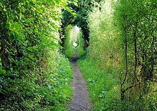
The footpath is waymarked by metal and plastic disks found attached to wooden and metal posts, trees and street furniture, and where this isn't possible stickers on lampposts etc. It has also spawned several circular routes that use sections of the main footpath. These are also waymarked.
This route is shown as a series of green diamonds on Ordnance Survey 1:25,000 maps and as a series of red diamonds on Ordnance Survey 1:50,000 maps.
Walbury Hill is also the start of the Test Way and is the start of the Combe Gibbet to Overton 16 Mile Trail Race, the first 11 miles of its route being on Wayfarer's Walk.
Places of interest
The following places of interest, hillfort sites and hills can be found along the length of the Walk (listed from southeast to northwest):
The Ridgeway is a ridgeway or ancient trackway described as Britain's oldest road. The section clearly identified as an ancient trackway extends from Wiltshire along the chalk ridge of the Berkshire Downs to the River Thames at the Goring Gap, part of the Icknield Way which ran, not always on the ridge, from Salisbury Plain to East Anglia. The route was adapted and extended as a National Trail, created in 1972. The Ridgeway National Trail follows the ancient Ridgeway from Overton Hill, near Avebury, to Streatley, then follows footpaths and parts of the ancient Icknield Way through the Chiltern Hills to Ivinghoe Beacon in Buckinghamshire. The National Trail is 87 miles (140 km) long.
The South Downs Way is a long distance footpath and bridleway running along the South Downs in southern England. It is one of 16 National Trails in England and Wales. The trail runs for 160 km (100 mi) from Winchester in Hampshire to Eastbourne in East Sussex, with about 4,150 m (13,620 ft) of ascent and descent.
Watership Down is a hill or a down at Ecchinswell in the civil parish of Ecchinswell, Sydmonton and Bishops Green in the English county of Hampshire, as part of the Hampshire Downs. It rises fairly steeply on its northern flank, but to the south the slope is much gentler. The summit is 778 ft (237 m) above sea level, one of the highest points in Hampshire.
Combe is a village and civil parish in the English county of Berkshire. The parish is situated on the top of the North Hampshire Downs near Walbury Hill and Combe Gibbet, overlooking the village of Inkpen and the valley of the River Kennet. In Walbury Hill, it includes the highest natural point in South East England.
The Avon Valley Path is a long-distance path, opened in 1992, which runs for 34 miles through the English counties of Wiltshire, Hampshire and Dorset.
The Clarendon Way is a recreational footpath in Hampshire and Wiltshire, England. It starts beside the waters of the River Itchen in the centre of Winchester and ends near the River Avon at Salisbury Cathedral. The path passes through the Clarendon Estate and close to the 12th century ruins of Clarendon Palace. The path also passes through Farley Mount Country Park and the villages of Pitton, The Winterslows, Broughton and King's Somborne. The path shares part of its route with the Monarch's Way long-distance footpath.
The Itchen Way is a 31.80-mile (51.18 km) long-distance footpath following the River Itchen in Hampshire, England, from its source near Hinton Ampner House to its mouth at Woolston. The walk finishes at Sholing railway station. The route has been promoted by the Eastleigh Group of the Ramblers with grant aid from Hampshire County Council and Eastleigh Borough Council. The route was altered and improved in 2008.
King's Way or the Allan King Way is a 45-mile-long-distance (72 km) footpath in Hampshire, England. This footpath was created by the Hampshire Area of the Ramblers' Association as a memorial to the late Allan King, a former Publicity Officer who was partly responsible for the formation of a number of Groups in Hampshire. The route runs from Portchester to Winchester via Bishops Waltham and passes by sites such as Portchester Castle, Fort Nelson, and Bishops Waltham Palace
The Pilgrims' Trail is a 155-mile long-distance footpath that connects Winchester Cathedral in Hampshire, England to Mont Saint-Michel in Normandy.
St Swithun's Way is a 34-mile (55 km) long-distance footpath in England from Winchester Cathedral, Hampshire to Farnham, Surrey. It is named after Swithun, a 9th-century Bishop of Winchester, and roughly follows the Winchester to Farnham stretch of the Pilgrims' Way. The route was opened in 2002 to mark the Golden Jubilee of Elizabeth II.
Hangers Way is a 21-mile-long-distance (34 km) footpath through Hampshire, England from Alton railway station to Queen Elizabeth Country Park where it meets the South Downs Way National Trail.
Combe Gibbet is a gibbet at the top of Gallows Down, near the village and just within the civil parish of Combe in Berkshire, England.
The Test Way is a 44-mile (71 km) long-distance footpath in England from Walbury Hill in West Berkshire to Eling in Hampshire, which follows much of the course of the River Test.
The Soberton and Newtown Millennium Walk 2000 is a 10-mile circular footpath through Hampshire, England around villages of Soberton and Newtown.
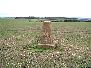
Walbury Hill is a summit of the North Wessex Downs in Berkshire, England. With an elevation of 297 metres (974 ft), it is the highest natural point in South East England. On the hill's summit is the Iron Age hill fort of Walbury Camp, whilst the flanks of the hill lie within the Inkpen and Walbury Hills SSSI. The hill is one of three nationally important chalk wild grasslands in the North Wessex Downs, the others being in the Rushmore and Conholt Downs SSSI and the Hog's Hole SSSI. The summit of the hill is marked by a triangulation pillar, but lies on private land with no public access, although public access is available to the north of the summit via a byway.
The Monarch's Way is a 625-mile (1,006 km) long-distance footpath in England that approximates the escape route taken by King Charles II in 1651 after being defeated in the Battle of Worcester. It runs from Worcester via Bristol and Yeovil to Shoreham, West Sussex.
Inkpen is a village and civil parish in West Berkshire, 3.5 miles (5.6 km) southeast of Hungerford, most of the land of which is cultivated fields with scattered woodland once part of a former forest of Savernake. Inkpen has boundaries with Wiltshire and Hampshire, including parts of Walbury Hill, the highest point in South East England, and Inkpen Hill.
The following are lists of recreational walks in Hampshire, England:
Inkpen Hill is a summit in Berkshire, England, with a maximum elevation of 291 m (955 ft). The hill is about 7 miles (11 km) southwest of Newbury on the Hampshire/Berkshire border and is part of the north-facing scarp of the North Hampshire Downs, a chalk ridge within the North Wessex Downs Area of Outstanding Natural Beauty. It lies between Walbury Hill, the county top of Berkshire, to the east and Ham Hill to the west. Parts of the hill lie within the Inkpen and Walbury Hills SSSI.
The Trent Valley Way is a waymarked long-distance footpath in England following the River Trent and its valley in the counties of Nottinghamshire and Lincolnshire.
This page is based on this Wikipedia article Text is available under the CC BY-SA 4.0 license; additional terms may apply. Images, videos and audio are available under their respective licenses.