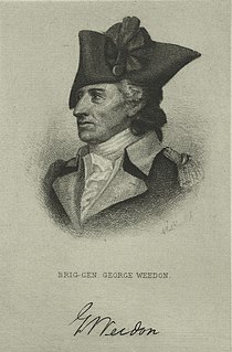
George Weedon (1734–1793) was an American soldier during the Revolutionary War from Fredericksburg, Colony of Virginia. He served as a brigadier general in the Continental Army and later in the Virginia militia. After the Revolutionary War ended he became an original member of the Society of the Cincinnati(Va.).

The Tug Fork is a tributary of the Big Sandy River, 159 miles (256 km) long, in southwestern West Virginia, southwestern Virginia, and eastern Kentucky in the United States. Via the Big Sandy and Ohio rivers, it is part of the watershed of the Mississippi River.

The Shenandoah River is a tributary of the Potomac River, 55.6 miles (89.5 km) long with two forks approximately 100 miles (160 km) long each, in the U.S. states of Virginia and West Virginia. The principal tributary of the Potomac, the river and its tributaries drain the central and lower Shenandoah Valley and the Page Valley in the Appalachians on the west side of the Blue Ridge Mountains, in northwestern Virginia and the Eastern Panhandle of West Virginia.

The Holston River is a 136-mile (219 km) river that flows from Kingsport, Tennessee, to Knoxville, Tennessee. Along with its three major forks, it comprises a major river system that drains much of northeastern Tennessee, southwestern Virginia, and northwestern North Carolina. The Holston's confluence with the French Broad River at Knoxville marks the beginning of the Tennessee River.

Hugh Mercer was a Scottish soldier and physician. He initially served with the Jacobite forces of Bonnie Prince Charlie, and with the British forces during the Seven Years' War, but later became a brigadier general in the Continental Army and a close friend to George Washington. Mercer died as a result of his wounds received at the Battle of Princeton and became a fallen hero as well as a rallying symbol of the American Revolution.

Sleepy Creek is a 44.0-mile-long (70.8 km) tributary of the Potomac River in the United States, belonging to the Chesapeake Bay's watershed. The stream rises in Frederick County, Virginia, and flows through Morgan County, West Virginia before joining the Potomac near the community of Sleepy Creek.

Beech Fork State Park is a state park located in Cabell County and Wayne County, West Virginia. The park is located on the tailwater shores of Beech Fork Lake, a flood control impoundment of the U.S. Army Corps of Engineers on the Beech Fork of Twelvepole Creek. Since its development in the mid-1970s, Beech Fork State Park has proven to be a popular recreation spot for the residents of nearby Barboursville and Huntington, West Virginia, as well as those living in the surrounding region. The park is located about 10 miles (16 km) south of the Hal Greer Exit of Interstate 64.
Catoctin Creek is a 14.1-mile-long (22.7 km) tributary of the Potomac River in Loudoun County, Virginia, with a watershed of 59,000 acres (240 km2). Agricultural lands make up 67 percent and forests 30 percent of Catoctin Creek's watershed. It is the main drainage system for the northern Loudoun Valley, including all of the Catoctin Valley.
The 3rd Virginia Regiment was raised on December 28, 1775, at Alexandria, Virginia, for service with the Continental Army. The 3rd Virginia's initial commander was Colonel Hugh Mercer, who was quickly promoted to Brigadier General. Its second commander, George Weedon, was also promoted to Brigadier General within a few months. Weedon was succeeded in command by Colonel Thomas Marshall, the father of Supreme Court Chief Justice John Marshall. During its time at Valley Forge its commander was Colonel William Heth. The regiment saw action in the New York Campaign, the Battles of Trenton, Princeton, Brandywine, Germantown, Monmouth and the Siege of Charleston. Most of the regiment was captured at Charlestown, South Carolina, on May 12, 1780, by the British, and the regiment was formally disbanded on November 15, 1783. James Monroe, Thomas Helm, John Francis Mercer and James Markham Marshall served as Lieutenants in this regiment.

Breaks Interstate Park is a bi-state state park located partly in southeastern Kentucky and mostly in southwestern Virginia, in the Jefferson National Forest, at the northeastern terminus of Pine Mountain. Rather than their respective state park systems, it is instead administered by an interstate compact between the states of Virginia and Kentucky. It is one of several interstate parks in the United States, but only one of two operated jointly under a compact rather than as two separate state park units. The Virginia Department of Conservation and Recreation and the Kentucky Department of Parks are still major partner organizations, however.

North Fork Mountain is a quartzite-capped mountain ridge in the Ridge and Valley physiographic province of the Allegheny Mountains of eastern West Virginia, USA. Kile Knob, at 4,588 feet, is the mountain's highest point, and Panther Knob and Pike Knob are nearly as high.

Slab Fork is an unincorporated community in Raleigh County, West Virginia, United States with a population of 202. Slab Fork is located along a stream of the same name and West Virginia Route 54. The ZIP code for Slab Fork is 25920.
Beards Fork is a census-designated place (CDP) and coal town in Fayette County, West Virginia, United States that was founded as a coal town. As of the 2010 census, its population was 199.

Dunkard Fork Wildlife Management Area is located on 470 acres (190 ha) in Marshall County near Moundsville, West Virginia. Mixed hardwoods cover most of the former Jacob Crow (1815-1901) (later C.C. Mooney [d. 1970] farm, site, whose major focus is a flood control lake on Dunkard Fork Wheeling Creek. The rolling terrain is punctuated with a few highwalls and ponds. Dunkard Fork WMA is located in northeast Marshall County along the Pennsylvania line on County Route 15. Construction of the dam was originally slated for a location upstream, but was later moved into West Virginia. Construction was underway by 1991 and the Jacob Crow farm was ruined. Archeological digs were conducted and photographs taken to document the site before the structures were razed.

Tug Fork Wildlife Management Area (WMA) is located about 10 miles northwest of Welch, West Virginia in McDowell County. Tug Fork WMA is located on 2,165 acres (876 ha) of steep terrain along hills above the Tug Fork River. The WMA is heavily forested, primarily with mixed hardwoods and yellow poplar/black cherry forests in the coves. The WMA is accessed from U.S. Route 52 at Premier. Several tracks and jeep trails provide walking access into the Tug Fork WMA from U.S. Route 52.

Hereford College is a self-governed residential college at the University of Virginia.

William Stone Weedon, was a scholar, university professor, and U.S. Navy Officer.

The Laurel Fork is a 15.7-mile-long (25.3 km) stream in Virginia and West Virginia, United States. The stream flows north from Highland County, Virginia, where its source and the majority of its length is located, to its mouth in Pendleton County, West Virginia. Laurel Fork is a tributary to the North Fork South Branch Potomac River, making it a part of the Potomac River watershed. The area surrounding Laurel Fork is home to several plant and animal species found nowhere else in Virginia, and is a prime example of a northern boreal forest in the state.


