
The Bernese Alps are a mountain range of the Alps, located in western Switzerland. Although the name suggests that they are located in the Berner Oberland region of the canton of Bern, portions of the Bernese Alps are in the adjacent cantons of Valais, Fribourg and Vaud, the latter being usually named Fribourg Alps and Vaud Alps respectively. The highest mountain in the range, the Finsteraarhorn, is also the highest point in the canton of Bern.

The Bernese Oberland is the highest and southernmost part of the canton of Bern, and one of the canton's five administrative regions. It constitutes the Alpine region of the canton and the northern side of the Bernese Alps, including many of its highest peaks, among which the Finsteraarhorn, the highest in both range and canton.
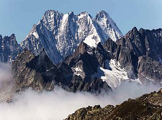
The Lauteraarhorn is a peak of the Bernese Alps, located in the canton of Bern. Together with the higher Schreckhorn, to which it is connected by a high ridge, it lies between the valleys of the Lower Grindelwald Glacier and the Unteraar Glacier, about 10 kilometres southeast of Grindelwald, the closest locality. The Lauteraarhorn belongs to the Aaremassif and is surrounded by large glaciers: the Lauteraargletscher and the Strahlegg-Gletscher and the Obers Ischmeer. Being off the main ridge of the Bernese Alps, all the glaciers surrounding the Lauteraarhorn and the Schreckhorn are part of the Aare basin. The Lauteraarhorn is the second highest summit lying wholly within the canton of Bern. Administratively, it is split between the municipalities of Grindelwald and Guttannen.

The Wildstrubel is a mountain of the Alps, straddling the border between the Swiss cantons of Bern and Valais. It forms a large glaciated massif, about 15 km wide, extending between the Rawil Pass and the Gemmi Pass. Along with the Muverans, the Diablerets and the Wildhorn, the Wildstrubel is one of the four distinct mountain massifs of the Bernese Alps that lie west of the Gemmi Pass. The massif of the Wildstrubel is at the centre between the valleys of Simmental (BE), Engstligental (BE) and the Rhone (VS), the exact location of the tripoint being the summit of the Schneehorn. It comprises several distinct summits, including the Wetzsteinhorn, the Rohrbachstein, the Weisshorn, the Pointe de la Plaine Morte, Mont Bonvin, the Trubelstock and the Schneehorn. The main crest with the almost equally high summits of the Mittelgipfel and the Grossstrubel forms an amphitheatre oriented eastward which ends at the Steghorn and the Daubenhorn. This area encloses the Wildstrubel Glacier. To the southwest, the Wildstrubel overlooks the high plateau of the Plaine Morte Glacier, which also includes an unnamed lake below the Schneehorn.

The Tschingelhorn is a mountain of the Bernese Alps, located on the border between the Swiss cantons of Bern and Valais. The summit of the Klein Tschingelhorn on the west is the tripoint between the valleys of Kandertal, Lauterbrunnental and Lötschental. The main summit lies between the Lauterbrunnental and the Lötschental.

The Balmhorn is a mountain in the Bernese Alps in Switzerland. Its summit ridge lies on the border between the cantons of Berne and the Valais.

The Wildhorn is a mountain of the Alps, straddling the border between the Swiss cantons of Bern and Valais. At 3,248 metres (10,656 ft) above sea level, it is the highest summit of the Bernese Alps west of the Gemmi Pass. It forms a large glaciated massif, about 10 km wide, extending between the Sanetsch Pass and the Rawil Pass. Along with the Muverans, the Diablerets and the Wildstrubel, the Wildhorn is one of the four distinct mountain massifs of the Bernese Alps that lie west of the Gemmi Pass. The massif of the Wildhorn is at the centre between the valleys of the Saane, Simme and the Rhone (Valais). It comprises several distinct summits, including the Arpelistock, Le Sérac, the Geltenhorn, the Sex Noir, the Sex Rouge, the Schnidehorn and the Six des Eaux Froides. The main crest is between the glaciers named Tungelgletscher and Glacier du Wildhorn. South of the main summit is the almost equally high summit of Mont Pucel. The Wildhorn is surrounded by several large mountain lakes: the Lac de Sénin, the Lauenensee, the Iffigsee, the Lac de Tseuzier and the Lac des Audannes. The Tungelgletscher, on the north-east face, was measured as 1.9 km in length in 1973.

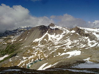
The Plaine Morte Glacier is a glacier located at an elevation of 2,750 m (9,020 ft), in the canton of Bern above Lenk and in the Valais above Crans-Montana in Switzerland. The ice field, which covers 7.88 square kilometres (3.04 sq mi), is located below the mountain of Wildstrubel in the Bernese Alps. Its largest tongue is also called in German Rezligletscher or Rätzligletscher.

The Ebnefluh, also known as the Äbeni Flue and the Ebenefluh, is a mountain of the Bernese Alps, located on the border between the Swiss cantons of Bern and Valais. It lies towards the eastern end of the Lauterbrunnen Wall.

The Hockenhorn is a mountain of the Bernese Alps, located on the border between the Swiss cantons of Bern and Valais. Its summit is 3,293 metres high and lies between the upper Kandertal and the Lötschental. On its southern (Valais) side lies a glacier named Milibachgletscher.

The Altels is a mountain of the Bernese Alps, located on the border between the Swiss cantons of Bern and Valais. It is situated in the Balmhorn massif, approximately halfway between Kandersteg and Leukerbad.
The Arpelistock is a mountain of the Bernese Alps, located on the border between the Swiss cantons of Bern and Valais. It belongs to the massif of the Wildhorn and lies approximately halfway between the Sanetsch Pass and the summit of the Wildhorn.

The Steghorn is a mountain of the Bernese Alps, located on the border between the Swiss cantons of Bern and Valais. It lies between the Engstligenalp (Bernese Oberland and the Gemmi Pass. The Steghorn belongs to the massif of the Wildstrubel.
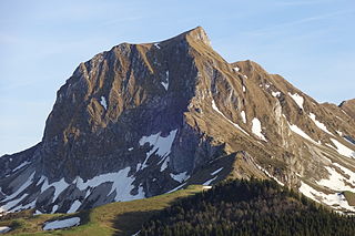
The Gantrisch is a mountain in the north-western Bernese Alps, located between the Simmental and the Aar valley in the canton of Bern. The mountain lies near Gurnigel Pass, from where it is usually climbed. A trail leads to the summit.
The Wandflue is a mountain of the Bernese Alps, located on the border between the Swiss cantons of Fribourg and Bern. It lies south of Jaun in the Gastlosen chain.
The Märe is a mountain of the Bernese Alps, located on the border between the Swiss cantons of Fribourg and Bern. The Märe lies approximately halfway between Schwarzsee and Oberwil im Simmental.

Mont Bonvin is a mountain of the Bernese Alps, overlooking Crans-Montana in the Swiss canton of Valais. The border with the canton of Bern runs one kilometre north of the summit.
The Rohrbachstein is a mountain of the Bernese Alps, located on the border between the Swiss cantons of Bern and Valais. It lies between the Rawil Pass and the Plaine Morte Glacier.

The Geltenhorn is a mountain of the Bernese Alps, located on the border between the Swiss cantons of Bern and Valais. It belongs to the massif of the Wildhorn and lies approximately halfway between the Arpelistock and the summit of the Wildhorn.

The Pointe de la Plaine Morte is a mountain of the Bernese Alps, located on the border between the Swiss cantons of Bern and Valais. It overlooks the large and flat glacier named Plaine Morte Glacier, from the south-west side.

