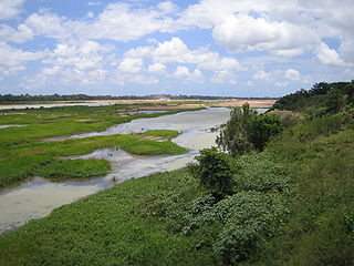
The Murray River is a river in Southeastern Australia. It is Australia's longest river at 2,508 km (1,558 mi) extent. Its tributaries include five of the next six longest rivers of Australia. Together with that of the Murray, the catchments of these rivers form the Murray–Darling basin, which covers about one-seventh the area of Australia. It is widely considered Australia's most important irrigated region.

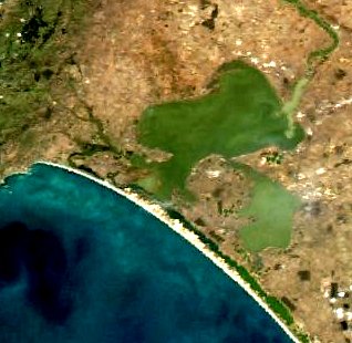
Coorong National Park is a protected area located in South Australia about 156 kilometres (97 mi) south-east of Adelaide, that predominantly covers a coastal lagoon ecosystem officially known as The Coorong and the Younghusband Peninsula on the Coorong's southern side. The western end of the Coorong lagoon is at the Murray Mouth near Hindmarsh Island and the Sir Richard Peninsula, and it extends about 130 kilometres (81 mi) south-eastwards. Road access is from Meningie. The beach on the coastal side of the peninsula, the longest in Australia, is also commonly called The Coorong.

The Burdekin River is a river located in North and Far North Queensland, Australia. The river rises on the northern slopes of Boulder Mountain at Valley of Lagoons, part of the western slope of the Seaview Range, and flows into the Coral Sea at Upstart Bay over 200 kilometres (124 mi) to the southeast of the source, with a catchment area of approximately 130,000 square kilometres (50,000 sq mi). The Burdekin River is Australia's largest river by (peak) discharge volume.

The Murray–Darling basin is a large geographical area in the interior of southeastern Australia, encompassing the drainage basin of the tributaries of the Murray River, Australia's longest river, and the Darling River, a right tributary of the Murray and Australia's third-longest river. The basin, which includes six of Australia's seven longest rivers and covers around one-seventh of the Australian landmass, is one of the country's most significant agricultural areas providing one-third of Australia's food supply. Located west of the Great Dividing Range, it drains southwestly into the Great Australian Bight and spans most of the states of New South Wales and Victoria, the Australian Capital Territory, and parts of the states of Queensland and South Australia.

Lake Alexandrina is a coastal freshwater lake located between the Fleurieu and Kangaroo Island and Murray and Mallee regions of South Australia, about 100 kilometres (62 mi) south-east of Adelaide. The lake adjoins the smaller Lake Albert and a coastal lagoon called The Coorong to its southeast, before draining into the Great Australian Bight via a short, narrow opening known as Murray Mouth.

Barwon River, a perennial river that is part of the Murray–Darling basin, is located in the north-west slopes and Orana regions of New South Wales, Australia.

Lake Albert, also known by its Ngarrindjeri name, Yarli, is a notionally fresh water lake near the mouth of the Murray River in South Australia. It is filled by water flowing in from the larger Lake Alexandrina at its mouth near Narrung. It is separated on the south by the Narrung Peninsula from the salt-water Coorong. The only major town on the lake is Meningie. Lakes Alexandrina and Albert are together known as the Lower Lakes.

Murray Mouth is the point at which the River Murray meets the Southern Ocean. The Murray Mouth's location is changeable. Historical records show that the channel out to sea moves along the sand dunes over time. At times of greater river flow and rough seas, the two bodies of water would erode the sand dunes to create a new channel leaving the old one to silt and disappear.

Wellington is a township in South Australia, Australia on the Murray River just upstream of where it empties into Lake Alexandrina. Its postcode is 5259. Wellington is in the Rural City of Murray Bridge. At the 2006 census, Wellington had a population of 295.

Coorong is a locality in the Australian state of South Australia which is associated with the lagoon known as the Coorong in the south-east of the state and which overlooks the continental coastline from the mouth of the Murray River about 80 kilometres south-east of the state capital of Adelaide to the immediate north of the town of Kingston SE extending for a distance of at least 140 kilometres (87 mi).

Clayton Bay is a town in South Australia located on Lake Alexandrina and Lower Murray River, part of the lower lakes and Coorong region at the end of the Murray River System. The town is located north of the north-east tip of Hindmarsh Island about 87 kilometres (54 mi) from Adelaide and 30.7 kilometres (19 mi) by road from Goolwa.
Water security in Australia became a major concern in Australia in the late 20th and early 21st century as a result of population growth, recurring severe droughts, effects of climate change on Australia, environmental degradation from reduced environmental flows, competition between competing interests such as grazing, irrigation and urban water supplies, and competition between upstream and downstream users. For example, there is competition for the resources of the Darling River system between Queensland, New South Wales and South Australia. Water reform was first placed on the national agenda at the 1994 Council of Australian Governments (COAG) meeting when a strategic framework was devised. As the knowledge of surface and groundwater systems grew and the awareness of the significance of sustainable water markets increased, further water reform was agreed to at the 2004 COAG meeting, under a national blueprint known as the National Water Initiative (NWI).

The Goolwa Barrages comprise five barrage structures in the channels separating Lake Alexandrina from the sea at the mouth of the River Murray and the Coorong in South Australia. They were constructed principally to reduce salinity levels in the lower reaches of the River Murray, Lake Alexandrina and Lake Albert, but also to stabilise the river level, for both upstream irrigation and pumping.

Pomanda Island is an island in the Australian state of South Australia, located in within Lake Alexandrina about 87 kilometres southeast of the Adelaide city centre and 12 kilometres south of the town of Wellington. It has an area of 34 hectares. It was the proposed site of a temporary weir of 2.6 kilometres length which was intended to protect River Murray water supplies, should it become necessary to let seawater into Lake Alexandrina.

The Menindee Lakes is a system of 9 large, but relatively shallow lakes, located in south-west New South Wales on the Darling (Barka) River, about 200 km upstream of the Darling River's junction with the River Murray. The Darling River is fed by nine major tributary river systems flowing from south-east Queensland and north and central NSW. The town of Menindee is close to the lakes and the nearest city is Broken Hill.

The Great Darling Anabranch, commonly called the Darling Anabranch, is an anabranch and ancestral path of the Darling River in the lower Murray-Darling basin in the Far West and Riverina regions of New South Wales, Australia.

The County of Russell is one of the 49 cadastral counties of South Australia. It was proclaimed in 1842 by Governor George Grey and named for Lord John Russell, who was involved with the early development of the (British) South Australian colony when he was Secretary of State for War and the Colonies. It covers a portion of the state bounded to the west by the eastern half of Lake Alexandrina and the section of the Murray River extending to Bowhill in the north and bounded to the south by the coastline adjoining the Coorong coastal lagoon and fully surrounds Lake Albert which is excluded from its extent. This includes the north western quarter of the contemporary local government area of Coorong District Council.

Nurrang Peninsula is a peninsula in the Australian state of South Australia located at the south east end of Lake Alexandrina. It is bounded by Lake Alexandrina to the west, by Lake Albert to the north and to the east, and by the Coorong to the south. While the name appears to have been in use since the 19th century and by all levels of government in South Australia, the name was not listed in the state government's official list of placenames until January 2020. Its extent is within the localities of Meningie West and Narrung.
Wellington East is a locality in the Murray Mallee on the east of the Murray River in South Australia where the river opens into Lake Alexandrina, the largest of the lakes at the end of the Murray-Darling system.

The Finniss River drains part of the east side of Fleurieu Peninsula into Lake Alexandrina in South Australia. It is part of the Murray–Darling basin.


