
Kukuihaele is a census-designated place (CDP) in Hawaiʻi County, Hawaiʻi, United States. The population was 336 at the 2010 census.
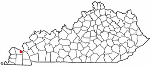
Farley is a census-designated place (CDP) in McCracken County, Kentucky, United States. The population was 4,701 at the 2010 census, a decline from 4,937 in 2000. It is part of the Paducah, KY-IL Micropolitan Statistical Area.

Lake Shore is a census-designated place and unincorporated community in Anne Arundel County, Maryland, United States, located east of Pasadena. The population of Lake Shore was 19,477 at the 2010 census.

Ames Lake is an unincorporated community and census-designated place (CDP) in King County, Washington, United States. The population was 1,486 at the 2010 census.

Baring is an unincorporated community and census-designated place (CDP) in King County, Washington, United States. The population was 220 at the 2010 census. It is located on U.S. Highway 2 about 23 miles (37 km) west of Stevens Pass, along a very flat and straight three-mile section of highway that has been dubbed the "Baring Straight", since US-2 is otherwise hilly and curvy through the mountains.

Cottage Lake is a census-designated place (CDP) in King County, Washington, United States. The population was 22,494 at the 2010 census. The lake itself falls within the 98072 ZIP code, while the developments east of the lake fall under the 98077 ZIP code.

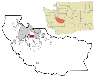
East Hill-Meridian is a former census-designated place (CDP) in King County, Washington, United States. The population was 29,878 at the 2010 census. The majority of the census area is now within the limits of Kent and Renton.

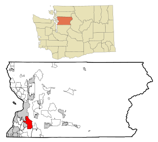
Lakeland North is a census-designated place (CDP) in King County, Washington, United States. The population was 12,942 at the 2010 census. Part of the community was annexed into neighboring Auburn in 2008.

Lakeland South is a census-designated place (CDP) in King County, Washington, United States. The population was 11,574 at the 2010 census.

Mirrormont is a census-designated place (CDP) in King County, Washington, United States, south of Issaquah. The population was 3,659 at the 2010 census. Within the last decade, the area has seen a shift in development as larger homes have been constructed in Cedar Grove, the Highlands at Tiger Mountain and Mirrormont.

Union Hill-Novelty Hill is a census-designated place (CDP) in King County, Washington, United States. The area was first recognized by the Census Bureau in the 2000 census. The population was 18,805 at the 2010 census.

Suquamish is a census-designated place (CDP) in Kitsap County, Washington, United States. The population was 4,140 at the 2010 census. Comprising the Port Madison Indian Reservation, it is the burial site of Chief Seattle and the site of the Suquamish tribe winter longhouse known as Old Man House.

Tracyton is a census-designated place (CDP) in Kitsap County, Washington, United States. Its population was 5,233 at the 2010 census. It was named for 19th century Secretary of the Navy Benjamin F. Tracy.

Prairie Ridge is a census-designated place (CDP) in Pierce County, Washington, United States. The population was 11,688 at the 2000 census.
Summit is a census-designated place (CDP) in Pierce County, Washington, United States. The population was 8,041 at the 2000 census.

Waller is a census-designated place (CDP) in Pierce County, Washington, United States. The population was 9,200 at the 2000 census.

Lake Stickney is a census-designated place (CDP) in Snohomish County, Washington, United States. The population was 7,777 at the 2010 census. The CDP was known as Paine Field-Lake Stickney prior to 2010. The new Lake Stickney CDP no longer contains the Paine Field airport.
Silver Firs is a census-designated place (CDP) in Snohomish County, Washington, United States. The population was 20,891 at the 2010 census. It lies northeast of the city of Mill Creek. Silver Firs is one of two CDPs that were created out of the former Seattle Hill-Silver Firs CDP in 2010, the other being Eastmont.

Bangor Base is a census-designated place (CDP) in Kitsap County, Washington, within U.S. Naval Base Kitsap on the Kitsap Peninsula. Its population was 6,054 at the 2010 census.
Farley is a census-designated place (CDP) in McCracken County, Kentucky, United States. The population was 4,701 at the 2010 census, a decline from 4,937 in 2000. It is part of the Paducah, KY-IL Micropolitan Statistical Area.
