
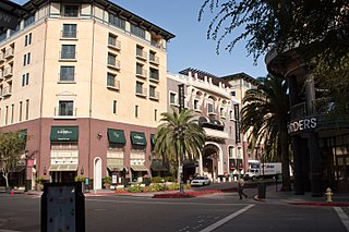
Midtown San Jose is a mixed commercial and residential district of San Jose, California, to the southwest of Downtown San Jose and east of West San Carlos.

Noe Valley is a neighborhood in the central part of San Francisco, California. It is named for Don José de Jesús Noé, noted 19th-century Californio statesman and ranchero, who owned much of the area and served as mayor.

Bernal Heights is a residential neighborhood in southeastern San Francisco, California. The prominent Bernal Heights hill overlooks the San Francisco skyline and features a microwave transmission tower. The nearby Sutro Tower can be seen from the Bernal Heights neighborhood.
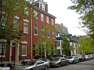
Washington Square West is a neighborhood in Center City, Philadelphia, Pennsylvania, United States. The neighborhood roughly corresponds to the area between 7th and Broad Streets and between Chestnut and South Streets, bordering on the Independence Mall tourist area directly northeast, Market East to the north, Old City and Society Hill to the East, Bella Vista directly south, Hawthorne to the southwest, and mid-town Philadelphia and Rittenhouse Square to the west. The area takes its name from Washington Square, a historic urban park in the northeastern corner of the neighborhood. In addition to being a desirable residential community, it is considered a hip, trendy neighborhood that offers a diverse array of shops, restaurants, and coffee houses. Washington Square West contains many gay-friendly establishments, especially in the gay village area of the neighborhood commonly known as the Gayborhood, which hosts annual events celebrating LGBT culture in Philadelphia, including OutFest.
The Greater Richmond, Virginia area has many neighborhoods and districts.

The Mexican Heritage Plaza - Centro Cultural de San José is a Chicano/Mexican-American cultural center in San Jose, California, located in the Mayfair neighborhood of East San Jose.
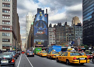
Eighth Avenue is a major north–south avenue on the west side of Manhattan in New York City, carrying northbound traffic below 59th Street. It is one of the original avenues of the Commissioners' Plan of 1811 to run the length of Manhattan, though today the name changes twice: At 59th Street/Columbus Circle, it becomes Central Park West, where it forms the western boundary of Central Park, and north of 110th Street/Frederick Douglass Circle, it is known as Frederick Douglass Boulevard before merging onto Harlem River Drive north of 155th Street.
Midtown is a collection of neighborhoods in Memphis, Tennessee, to the east of Downtown.
West San Jose is the western region of San Jose, California which borders the cities of Santa Clara, Cupertino, Saratoga, and Campbell. The area of West San Jose extends as far north as Stevens Creek Blvd, as far east State Route 17, as far south as State Route 85, and as far west as De Anza Boulevard. The region is primarily represented by San Jose City Council District 1.
Mahncke Park is an urban neighborhood and park located on the eastern fringe of Midtown San Antonio, Texas, USA.

Wynwood is a neighborhood in Miami, Florida. Wynwood is known for being an entertainment district, with artwork, restaurants, breweries, clothing stores, and dance venues, among other retail options. Formerly an industrial district, the area is now known for the murals that cover the walls of many of the buildings and many of the sidewalks. It is north of Downtown Miami and Overtown, and adjacent to Edgewater. Wynwood has two major sub-districts, the Wynwood Art District in northern Wynwood, and the Wynwood Fashion District along West 5th Avenue. Wynwood roughly is divided by North 20th Street to the south, I-195 to the north, I-95 to the west and the Florida East Coast Railway to the east.
Midtown Sacramento is a historical district and neighborhood just east of Downtown Sacramento. Officially, Midtown's borders are R Street on the South, J Street on the North, 16th Street on the West and 30th Street on the East. However, the streets in Sacramento's original "grid" that are east of 16th Street cover the area commonly called "Midtown". This more general definition covers an area bounded by Broadway on the South, C street and the Southern Pacific rail lines on the North, 16th Street on the West and Alhambra Boulevard on the East.

Evergreen Historic District is one of the oldest neighborhoods in Memphis, Tennessee.
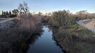
The Guadalupe River Trail is an 11-mile (18 km) pedestrian and bicycle path in the city of San Jose, California. The path runs along the banks of the Guadalupe River. The trail is currently composed of two discontinuous segments: a shorter "upper" segment in the Almaden Valley neighborhood of San Jose and a longer "lower" segment through Downtown San Jose to Alviso. This trail is heavily used for both recreation and commuting, as it provides direct access to Downtown San Jose from many of the outlying neighborhoods. The trail is paved.

Midtown South is a macro-neighborhood of the borough of Manhattan in New York City, generally characterized as constituting the southern portion of Midtown Manhattan. Midtown Manhattan hosts over 700,000 daily employees as a busy hub for workers, residents, and tourists. The Empire State Building, the Flatiron Building, Pennsylvania Station, Madison Square Garden, the Macy's Herald Square flagship store, Koreatown, and NYU Langone Medical Center are all located in Midtown South.
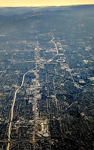
Stevens Creek Boulevard is a major thoroughfare in Santa Clara County, California, spanning from San Carlos Street, in San Jose's West San Carlos district in the East to Permanente, in the Santa Cruz Mountains west of Cupertino. It is a part of the larger Stevens Creek Boulevard/San Carlos Street corridor. Freeways that intersect it include I-880/SR 17, SR 85, and I-280.
San Jose is a neighborhood in southern Albuquerque, New Mexico. It was originally a separate village but was absorbed into the city in the 20th century. San Jose was first settled as a Hispanic farming community in the mid-1800s but transitioned to a working-class urban neighborhood after the arrival of the railroad in 1880. The neighborhood includes a mix of residential and industrial properties with a commercial district centered on Broadway Boulevard.

The Paseo de San Carlos is a pedestrian paseo in Downtown San Jose, California, spanning across San Jose State University's campus.

