Newport is a market town in the borough of Telford and Wrekin in Shropshire, England. It lies 7 miles (11 km) north-east of Telford town centre, 12 miles (19 km) west of Stafford, and is near the Shropshire-Staffordshire border. The 2001 census recorded 10,814 people living in the town's parish, which rose to 11,387 by the 2011 census.

Stafford is a market town and the county town of Staffordshire, England. It is located about 15 miles (24 km) south of Stoke-on-Trent, 15 miles (24 km) north of Wolverhampton, and 24 miles (39 km) northwest of Birmingham. The town had a population of 71,673 in 2021, and is the main settlement within the larger Borough of Stafford, which had a population of 136,837 in 2021.

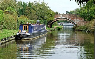
The Shropshire Union Canal, nicknamed the "Shroppie", is a navigable canal in England. The Llangollen and Montgomery canals are the modern names of branches of the Shropshire Union (SU) system and lie partially in Wales.
South Staffordshire is a local government district in Staffordshire, England. Its council is based in Codsall. Other notable settlements include Brewood, Cheslyn Hay, Coven, Essington, Featherstone, Four Ashes, Great Wyrley, Huntington, Kinver, Landywood, Penkridge, Perton, Wedge Mills, Weston-under-Lizard and Wombourne. The district covers a largely rural area lying immediately to the west and north-west of the West Midlands conurbation.
Penkridge is a large village and civil parish in South Staffordshire District in Staffordshire, England. It is to the south of Stafford, north of Wolverhampton, west of Cannock, east of Telford and south-east of Newport.

Staffordshire is a landlocked county in the West Midlands of England. It adjoins Cheshire to the north west, Derbyshire and Leicestershire to the east, Warwickshire to the south east, West Midlands and Worcestershire to the south, and Shropshire to the west. The historic county of Staffordshire includes Wolverhampton, Walsall, and West Bromwich, these three being removed for administrative purposes in 1974 to the new West Midlands authority. The resulting administrative area of Staffordshire has a narrow southwards protrusion that runs west of West Midlands to the border of Worcestershire. The city of Stoke-on-Trent was removed from the admin area in the 1990s to form a unitary authority, but is still part of Staffordshire for ceremonial and traditional purposes.
Oxley is a suburb of Wolverhampton, West Midlands, and a ward of the City of Wolverhampton Council. Its area code is WV10. It is situated in the north of the city, bordering South Staffordshire and the Bushbury North, Bushbury South and Low Hill, St Peter's and Tettenhall Regis wards. It forms part of the Wolverhampton North East constituency.
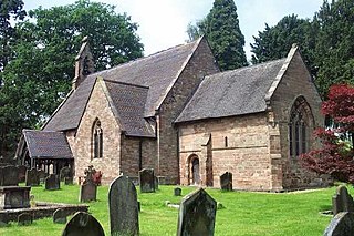
Featherstone is a town in the district of South Staffordshire, England, near to the border with Wolverhampton.

The River Penk is a small river flowing through Staffordshire, England. Its course is mainly within South Staffordshire, and it drains most of the northern part of that district, together with some adjoining areas of Cannock Chase, Stafford, Wolverhampton, and Shropshire. It flows into the River Sow, which is a tributary of the River Trent, so its waters flow ultimately into the North Sea via the Humber Estuary.

The Four Counties Ring is a canal ring which links the four English counties of Cheshire, Staffordshire, Shropshire and West Midlands.
Levedale is a small somewhat elongated English village situated some 4 miles southwest of Stafford, 2 miles northwest of Penkridge and a mile west of Dunston, Staffordshire. The population as taken at the 2011 census can be found under Penkridge

Lapley is a village and former civil parish, now in the parish of Lapley, Stretton and Wheaton Aston, in the South Staffordshire district, in the county of Staffordshire, England. It is some 3.5 miles WSW of Penkridge, 1.5 miles east of Wheaton Aston, 0.5 miles northeast of the Shropshire Union Canal, 1.5 miles north of Watling Street, and 6 miles SSW of Stafford. In 1961 the parish had a population of 840. On 1 April 1986 the parish was abolished and merged with Stretton to form "Lapley and Stretton", part also went to Penkridge.
Stretton is a village and former civil parish, now in the parish of Lapley, Stretton and Wheaton Aston, in the South Staffordshire district, in the county of Staffordshire, England. It is just north of the A5 road. In 1961 the parish had a population of 176.

Lapley, Stretton and Wheaton Aston is a civil parish in the South Staffordshire district, in the county of Staffordshire, England. The population of the civil parish at the 2011 census was 2,548.

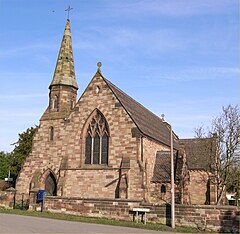
Penkridge is a village and parish in Staffordshire with a history stretching back to the Anglo-Saxon period. A religious as well as a commercial centre, it was originally centred on the Collegiate Church of St. Michael and All Angels, a chapel royal and royal peculiar that maintained its independence until the Reformation. Mentioned in Domesday, Penkridge underwent a period of growth from the 13th century, as the Forest Law was loosened, and evolved into a patchwork of manors of greatly varying size and importance, heavily dependent on agriculture. From the 16th century it was increasingly dominated by a single landed gentry family, the Littletons, who ultimately attained the Peerage of the United Kingdom as the Barons Hatherton, and who helped modernise its agriculture and education system. The Industrial Revolution inaugurated a steady improvement in transport and communications that helped shape the modern village. In the second half of the 20th century, Penkridge grew rapidly, evolving into a mainly residential area, while retaining its commercial centre, its links with the countryside and its fine church.

Royal Air Force Wheaton Aston, or more simply RAF Wheaton Aston, was a Royal Air Force station located just outside of the village of Wheaton Aston in Staffordshire, England. The base was actually in the hamlet of Little Onn which is 1.2 miles (2 km) north west of Wheaton Aston. The base was known locally as Little Onn or RAF Little Onn, but the policy of naming Royal Air Force stations was down to which parish the Station Headquarters was in.
Lapley, Stretton and Wheaton Aston is a civil parish in the district of South Staffordshire, Staffordshire, England. It contains 54 listed buildings that are recorded in the National Heritage List for England. Of these, one is listed at Grade I, the highest of the three grades, four are at Grade II*, the middle grade, and the others are at Grade II, the lowest grade. The parish contains the villages of Lapley, Stretton, and Wheaton Aston, and the surrounding countryside. Most of the listed buildings are houses and associated structures, cottages. farmhouses, and farm buildings, the earlier of which are timber framed or have a timber framed core. The Shropshire Union Canal passes through the parish, and the listed buildings associated with this are bridges, aqueducts and a milepost. The other listed buildings include churches and items in the churchyards, country houses and associated structures, and a former watermill.
Stone, Great Wyrley and Penkridge is a proposed constituency of the House of Commons in the UK Parliament. Further to the completion of the 2023 Periodic Review of Westminster constituencies, it will first be contested at the next general election.