
The Nelson River is a river of north-central North America, in the Canadian province of Manitoba. The river drains Lake Winnipeg and runs 644 kilometres (400 mi) before it ends in Hudson Bay. Its full length is 2,575 kilometres (1,600 mi), it has mean discharge of 2,370 cubic metres per second (84,000 cu ft/s), and has a drainage basin of 1,072,300 square kilometres (414,000 sq mi), of which 180,000 square kilometres (69,000 sq mi) is in the United States.

The Saskatchewan River is a major river in Canada. It stretches about 550 kilometres (340 mi) from where it is formed by the joining together of the North Saskatchewan and South Saskatchewan Rivers to Lake Winnipeg. It flows roughly eastward across Saskatchewan and Manitoba to empty into Lake Winnipeg. Through its tributaries the North Saskatchewan and South Saskatchewan, its watershed encompasses much of the prairie regions of Canada, stretching westward to the Rocky Mountains in Alberta and north-western Montana in the United States.

The Churchill River is a major river in Alberta, Saskatchewan and Manitoba, Canada. From the head of the Churchill Lake it is 1,609 kilometres (1,000 mi) long. It was named after John Churchill, 1st Duke of Marlborough and governor of the Hudson's Bay Company from 1685 to 1691.
The Fond du Lac River is one of the upper branches of the Mackenzie River system, draining into the Arctic Ocean, located in northern Saskatchewan, Canada. The river is 277 kilometres (172 mi) long, has a watershed of 66,800 square kilometres (25,800 sq mi), and its mean discharge is 300 cubic metres per second (11,000 cu ft/s).
Primrose Lake is a large lake in the Canadian provinces of Saskatchewan and Alberta in the Churchill River drainage basin. The lake straddles the Saskatchewan / Alberta border, with most of the water surface in Saskatchewan with only the south-west corner of the lake in Alberta. It is north of the better known Cold Lake, which also straddles the border.

The geography of Saskatchewan is unique among the provinces and territories of Canada in some respects. It is one of only two landlocked regions and it is the only region whose borders are not based on natural features like lakes, rivers, or drainage divides. The borders of Saskatchewan, which make it very nearly a trapezoid, were determined in 1905 when it became a Canadian province. Saskatchewan has a total area of 651,036 square kilometres (251,366 sq mi) of which 591,670 km2 (228,450 sq mi) is land and 59,366 km2 (22,921 sq mi) is water.

Churchill Lake is a glacial lake in the north-west part of the Canadian province of Saskatchewan. Frobisher Lake flows in from the north while Peter Pond Lake flows in from the east through the Kisis Channel. Highway 155 crosses this channel at the village of Buffalo Narrows.
The Bolton River is a river in the Hudson Bay drainage basin in Census Division No. 22 - Thompson-North Central, Northern Region, Manitoba, Canada. It is about 115 kilometres (71 mi) long and begins at Musketasonan Lake, about 20 kilometres (12 mi) south of Molson Lake, at an elevation of 249 metres (817 ft). It flows northeast through Little Bolton Lake at an elevation of 224 metres (735 ft), Rushforth Lake at an elevation of 218 metres (715 ft), Bolton Lake at an elevation of 212 metres (696 ft), where it takes in the right tributary Nikik River, and Kakwusis Lake at an elevation of 208 metres (682 ft). The river continues northeast over the twin Kasukwapiskechewak Rapids, then over the twin Kakwu Rapids, and empties into Aswapiswanan Lake at an elevation of 186 metres (610 ft), about 60 kilometres (37 mi) west southwest of the community of Gods Lake Narrows. The Bolton River's waters eventually flow into Gods Lake, and via the Gods River and the Hayes River into Hudson Bay.

Black Lake is a lake in the Mackenzie River drainage basin in northern Saskatchewan, Canada. It is about 55 kilometres (34 mi) long, 17 kilometres (11 mi) wide, has an area of 464 square kilometres (179 sq mi), and lies at an elevation of 281 metres (922 ft). The primary inflows are the Chipman River, Cree River, Fond du Lac River, and Souter River; the primary outflow is Fond du Lac River, which flows via the Mackenzie River into the Arctic Ocean.
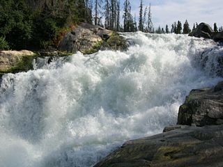
The Rapid River is a short river in central Saskatchewan, Canada, about 13 kilometres (8 mi) east of the community of Stanley Mission. It is part of the Churchill River drainage basin. The river is about 1,000 metres (3,281 ft) long and flows north from Iskwatikan Lake, which lies downstream from Lac la Ronge, over the Nistowiak Falls, one of the tallest in Saskatchewan, and the Fisher Rapids, to Nistowiak Lake on the Churchill River, which flows to Hudson Bay. The entire river is within Lac La Ronge Provincial Park.
Summit Lake is a lake in Rainy River District, Ontario, Canada. It is about 790 metres (2,592 ft) long and 360 metres (1,181 ft) wide, and lies at an elevation of 380 metres (1,247 ft) about 18 kilometres (11 mi) southeast of the community of Nestor Falls. The lake is in the Nelson River system in the Hudson Bay drainage basin. There are no primary inflows, and the primary outflow, on the west side of the lake, is an unnamed creek west to Kishkutena Lake on the Sabaskong River, which flows into Lake of the Woods, and then via the Winnipeg River and Nelson River into Hudson Bay. The Height of Land portage runs from the north tip of the lake to Kishkutena Lake.
Merrill Creek is a creek in the Moira River and Lake Ontario drainage basins in Hastings and Lennox and Addington Counties, Ontario, Canada.
Whitefish Lake is a lake in the Moira River and Lake Ontario drainage basins on the border between the Cashel portion of Tudor and Cashel, Hastings County and Addington Highlands, Lennox and Addington County in Ontario, Canada.
The Whitefish River is a river in the James Bay and Moose River drainage basins in Cochrane and Timiskaming Districts in northeastern Ontario, Canada. It flows 75 kilometres (47 mi) from Mount Sinclair Lake to its mouth at Night Hawk Lake, the source of the Frederick House River, a tributary of the Abitibi River.
Goose River is a river in the Hudson Bay drainage basin in the Northern Region of Manitoba and Division No. 18 in Saskatchewan, Canada, approximately 19 kilometres (12 mi) south-east of Bakers Narrows.

The Reindeer River is a river in northern Saskatchewan in the Canadian Shield. It flows south from Reindeer Lake to the Churchill River. The river's flow is regulated by the Whitesand Dam located between Marchand Lake and Fafard Lake.
The Cochrane River is a river in Canadian provinces of Manitoba and Saskatchewan. Located in the boreal forest of the Canadian Shield, it flows from Wellbelove Bay on the northern end of Wollaston Lake in north-eastern Saskatchewan to the north-east end of Reindeer Lake in Manitoba. The river has a drainage basin of 28,400 square kilometres (11,000 sq mi) and is part of the Churchill River drainage basin.
The Nemei River is a tributary of the Churchill River. It rises in Nemei Lake and flows northward to join Churchill River near Sandy Bay. It runs through low relief terrain of the Canadian Shield. The climate is sub-arctic.
Greig Lake is a lake in Meadow Lake Provincial Park in the Canadian Province of Saskatchewan in the boreal forest ecozone of Canada. On the eastern shore of the lake is the resort village of Greig Lake and Greig Lake Campground. The south-west corner of the lake has a resort called Waters Edge Eco Lodge. The lake is accessed from Highway 224 at the south end.
First Mustus Lake is a lake in Meadow Lake Provincial Park in the Canadian Province of Saskatchewan in the boreal forest ecozone of Canada. The lake is the first of four lakes in a row named Mustus in the Rusty Creek watershed. The other lakes are Second, Third, and Fourth Mustus. Rusty Creek and the lakes are part of the Waterhen River drainage basin. The Waterhen River is a tributary of the Beaver River, which flows north into Lac Île-à-la-Crosse and the Churchill River, a major tributary in the Hudson Bay drainage basin. Highway 224 provides access to both First and Second Mustus Lakes.

