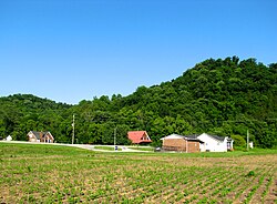
Turtletown is an unincorporated community in Polk County, Tennessee, United States. Turtletown is located on Tennessee State Route 68 6.5 miles (10.5 km) north-northeast of Ducktown. Turtletown is in a primarily mountainous terrain, covered in forests except for areas cleared by farmers, ponds, or roads. Turtletown has a post office with ZIP code 37391. Turtletown's borders, however, in the eyes of some are disputed. According to one, parts of it are known as Dogtown, which appears on a few local maps. However, to others, it is simply all Turtletown and Dogtown does not exist. The only known map that contains this is the USGS map of the area, and a U.S. Forest Service map. There is an abandoned school, Turtletown School, across the street from the Post Office.

Delano is an unincorporated community in Polk County, Tennessee, United States. Delano is located near the junction of U.S. Route 411, Tennessee State Route 30, and Tennessee State Route 163 4.3 miles (6.9 km) south-southwest of Etowah. Delano has a post office with ZIP code 37325, which opened on August 14, 1909.
Old Fort is an unincorporated community in Polk County, Tennessee, United States. Old Fort is located along U.S. Route 411, Tennessee State Route 33 and a CSX Transportation line 8.75 miles (14.08 km) south-southwest of Benton. Oldfort has a post office with ZIP code 37362.
Reliance is an unincorporated community in Polk County, Tennessee, United States. Reliance is located on the Hiwassee River at the junction of Tennessee State Route 30 and Tennessee State Route 315, 8.8 miles (14.2 km) east of Benton. Reliance had a post office until it closed on May 21, 2011; it still has its own ZIP code, 37369.

Smartt is an unincorporated community in Warren County, Tennessee, United States. Smartt is located along Tennessee State Route 55 and the Caney Fork and Western Railroad 4.5 miles (7.2 km) southwest of McMinnville. Smartt has a post office with ZIP code 37378.

Lancing is an unincorporated community in Morgan County, Tennessee, United States. Lancing is located along Tennessee State Route 62 and the Norfolk Southern Railway 3.35 miles (5.39 km) west-northwest of Wartburg, and northeast of the Catoosa Wildlife Management Area. Lancing has a post office with ZIP code 37770.
Moss is an unincorporated community in Clay County, Tennessee, United States. Moss is located along Tennessee State Route 52, 6.8 miles (10.9 km) west-northwest of Celina. Moss has a post office with ZIP code 38575.
Pickwick Dam is an unincorporated community in Hardin County, Tennessee, United States. Pickwick Dam is located on the Tennessee River south of the Pickwick Landing Dam. Pickwick Dam has a post office with ZIP code 38365.
Holladay is an unincorporated community in Benton and Decatur counties in the U.S. state of Tennessee. Holladay is located along Tennessee State Route 192 13.3 miles (21.4 km) south-southwest of Camden. Another portion of the community is located at the intersection of I-40 and US 641/SR 69. Holladay has a post office with ZIP code 38341, which opened on February 23, 1887.
Only is an unincorporated community in Hickman County, Tennessee, United States. Only is located on Tennessee State Route 229 near Tennessee State Route 50 and Interstate 40, 13.9 miles (22.4 km) west-northwest of Centerville. Only has a post office with ZIP code 37140.
Beechgrove, also known as Beech Grove, is an unincorporated community in Coffee County, Tennessee, United States. Beechgrove is located in northwestern Coffee County at the junction of Interstate 24, U.S. Route 41, and State Route 64. Beechgrove has a post office with ZIP code 37018.

Pruden is an unincorporated community located partly in Bell County, Kentucky and partly in Claiborne County, Tennessee, in the southeastern United States. It is located along Tennessee State Route 90 and Kentucky Route 74, which intersect at the state line, in the upper Clearfork Valley. Pruden had a post office on the Tennessee side of the border from September 20, 1906, to May 21, 2011; it still has its own ZIP code, 37851.
Nunnelly is an unincorporated community in Hickman County, Tennessee, United States. Nunnelly is located at the junction of Tennessee State Route 48 and Tennessee State Route 230 5.6 miles (9.0 km) north of Centerville. Nunnelly has a post office with ZIP code 37137.

Kelso is an unincorporated community in Lincoln County, Tennessee, United States. Kelso is located along U.S. Route 64 6 miles (9.7 km) east-southeast of Fayetteville. Kelso has a post office with ZIP code 37348. The community is home to the original Benjamin Prichard's distillery.

Mulberry is an unincorporated community in Lincoln County, Tennessee, United States. Mulberry is located along Tennessee State Route 50, 7.4 miles (11.9 km) northeast of Fayetteville. Mulberry has a post office with ZIP code 37359, which opened on January 7, 1828. The community was named for the red mulberry plants found in the area.

Flintville is an unincorporated community and census-designated place (CDP) in Lincoln County, Tennessee, United States. As of the 2010 census, its population was 627. Flintville is located along Tennessee State Route 275 10.5 miles (16.9 km) southeast of Fayetteville. Flintville has a post office with ZIP code 37335, which opened on February 16, 1861.

Pelham is an unincorporated community and census-designated place (CDP) in Grundy County, Tennessee, United States. As of the 2010 census, its population was 403. Pelham is located at the junction of U.S. Route 41, State Route 2, and State Route 50 near the base of the Cumberland Plateau, 5.35 miles (8.61 km) north-northwest of Monteagle. Pelham has a post office with ZIP code 37366, which opened on April 4, 1832.
Tipton is a neighborhood in the town of Atoka in Tipton County, Tennessee, United States, which was previously a distinct, unincorporated community. Tipton has its own post office with ZIP code 38071.
Summitville is an unincorporated community in Coffee County, Tennessee, United States. Summitville is located along the Caney Fork and Western Railroad near Tennessee State Route 55, 7.6 miles (12.2 km) northeast of Manchester. Summitville has a post office with ZIP code 37382, which opened on June 5, 1877. The Crouch-Ramsey Family Farm, which is listed on the National Register of Historic Places, is located near Summitville.
Princeton is an unincorporated community in Jackson County, Alabama, United States. Princeton is located on Alabama State Route 65 in the upper Paint Rock Valley. Skyline lies just over 7 miles (11 km) miles to the east atop the Cumberland Plateau, and the Alabama-Tennessee state line passes several miles to the north. Princeton has a post office with ZIP code 35766.