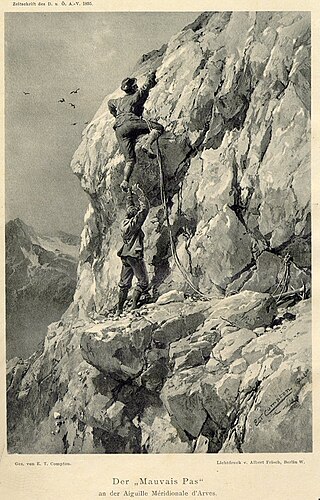
Karl Blodig was an Austrian mountaineer, optician, and writer. Blodig was the first to successfully climb all Alpine peaks of over 4000 meters, completing his final summit around 1911. He wrote about these climbs in his book Die Viertausender der Alpen, first published in 1923.

The Tre Cime di Lavaredo, also called the Drei Zinnen ; pronounced[ˌdʁaɪˈtsɪnən] ), are three distinctive battlement-like peaks, in the Sexten Dolomites of northeastern Italy. They are one of the best-known mountain groups in the Alps. The three peaks, from east to west, are:

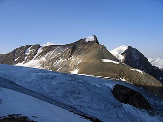
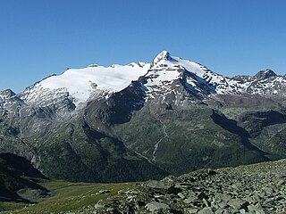
The Großes Wiesbachhorn is a mountain in the federal state of Salzburg, Austria and, at 3,564 m above sea level (AA), is the third-highest peak of the Hohe Tauern range.
The Hochfeiler is a mountain, 3,510 metres high, and the highest peak in the Zillertal Alps on the border between Tyrol, Austria, and South Tyrol, Italy.
The Hochgall is a mountain of the Rieserferner group in the High Tauern. the summit is in South Tyrol, Italy, just 500 m from the Austrian border.

The Rötspitze is a mountain in the Hohe Tauern on the border between Tyrol, Austria, and South Tyrol, Italy.
At the height of 3,770 metres (12,370 ft) the Kleinglockner is the third highest mountain summit in Austria. However, with a prominence of only 17 metres it is arguable whether it can be counted as an independent mountain, or just as a subpeak of the Großglockner. It lies in the Glockner Group of Austria's Central Alps, the middle section of the Hohe Tauern. Geographically and geologically speaking, it is viewed a secondary summit of the neighbouring Großglockner, but in the literature, in view of its importance to mountaineering, it is in some cases treated as separate. Its peak forms part of the Glockner crest or ridge (Glocknerkamm) and lies exactly on the border between the Austrian state of Carinthia and Lienz District in the East Tyrol. The Kleinglockner has the shape of a sharp edge, covered with the so-called Glockner Cornice (Glocknerwechte) and, depending on the conditions, can make the ascent of the mountain dangerous to almost impossible. The climbing history of the Kleinglockner is closely linked to that of the Großglockner, because the first climbers, coming from the south and east, had to cross it.
The Eiskögele is a 3,426-metre-high (11,240 ft) mountain in the Glockner Group in the western part of the main Tauern chain, a range of the Austrian Central Alps. It lies right on the border between the Austrian states of Salzburg, Carinthia and East Tyrol and thus forms a tripoint. The mountain has the shape of an ice-covered horn with a mighty North Face, a prominent Northeast Ridge (Nordostgrat) and a sharp firn edge (Firnschneide) to the west. From its base, the Oberwalder Hut, it is easy to reach via the Pasterzeboden glacier. It was first climbed on 30 July 1872 by the tourist B. Lergetporer from Schwaz and mountain guides, Michel Groder and Josef Kerer. The first solo ascent of the mountain was achieved in August 1891 by Ludwig Kohn from Vienna as part of a crossing from the Schneewinkelkopf.

The Fuscherkarkopf, sometimes also written Fuscher-Kar-Kopf in German and formerly also called the Fuschereiskarkopf, is one of the twin peaks of a mountain in the Glockner Group in the centre of the main mountain chain in the High Tauern, a range in the Austrian Central Alps. The mountain lies right on the border between the Austrian states of Salzburg and Carinthia. The main peak is 3,331 metres high, but the northwest summit is only 3,252 metres high. The two peaks are about 500 metres apart and linked by a curved firn-covered ridge. Further sharp, prominent ridges run away to the northwest and west, forming the main crest of the Tauern. To the southwest the Heiligenblut Open Face branches off, a mighty side ridge that starts as the southeast ridge (Südostgrat) at the Fuscherkarkopf. The northwest summit has a great, 650-metre-high (2,130 ft) West Face (Westwand), that used to be covered with firn, but today is covered with loose rock slabs. The mountain is easy to reach from the Hofmanns Hut over the southwest ridge (Südwestgrat) and offers a good view of the Großglockner and the Pasterze. The peak was first climbed in the 1840s by the hunter, Gregor Maier, known as Badhans, from Fusch.
The Hinterer Bratschenkopf is a mountain in the Glockner Group on the Fusch-Kaprun ridge in the High Tauern, a high mountain range in the Austrian Central Alps. According to the listed sources it is 3,412 metres high, but the Austrian Federal Office for Metrology and Survey gives its height as 3,413 metres. The mountain lies in the Austrian state of Salzburg. It appears from the north, east and south as a gently curved firn summit, but from the west it has a mighty, 1,400-metre-high (4,600 ft) and 40 to 60° rock face. A steep, 500-metre-long (1,600 ft) knife-edge ridge bears away from the mountaintop to the north. Due to its close proximity to the Heinrich Schwaiger Haus, the summit is a popular viewing point. The peak was first climbed on 18 September 1869 by the Munich Alpinist, Karl Hofmann, the Prague businessman, Johann Stüdl, and mountain guides Thomas Groder and Josef Schnell from Kals am Großglockner.

The Glocknerwand is a mountain in the Glockner Group in the Austrian Central Alps in the central region of the High Tauern. According to the literature it is 3,721 metres high, but the Austria Federal Office for Metrology and Survey gives its height as 3,722 metres. It is separated from Austria's highest peak, the neighbouring Großglockner, by the col known as the Untere Glocknerscharte (3596 m). The mountain lies on the boundary between East Tyrol and Carinthia.

The Glocknerhorn and Teufelshorn are two nearby mountain peaks in the Glockner Group in the Austrian Central Alps in the central part of the High Tauern. According to the literature, Teufelshorn is 3,677 metres high. The Austrian Federal Office for Metrology and Survey gives Glocknerhorn's elevation as 3,680 metres, but naming it "Teufelshorn" by mistake. Both lie on the Northwest Ridge (Nordwestgrat) of Austria's highest peak, the neighbouring Großglockner, along which the border between the Austrian federal states of Tyrol and Carinthia runs. The lower Teufelshorn in the west has a turret-like summit that juts about 30 metres above the massif itself and, together with the higher and similar-looking Glocknerhorn in the east, forms a twin peak. The Teufelshorn was first climbed on 8 August 1884 by Moriz von Kuffner, guided by Christian Ranggetiner and E. Rubesoier. The 3,680-metre-high (12,070 ft) Glocknerhorn, by contrast, had already been conquered on 29 August 1879 by the Alpinists, Gustav Gröger and Christian Ranggetiner.
The Hoher Tenn, formerly also called the Hochtenn, is a double-peaked mountain in the Austrian federal state of Salzburg. It has a southwest summit, called the Bergspitze with a height of 3,368 metres (11,050 ft), and a northeast summit, the Schneespitze, which is 3,317 metres (10,883 ft) high. The Tenn belongs to the Glockner Group in the central part of the High Tauern in the Austrian Central Alps. Between the two summits at a height of 3,293 metres (10,804 ft) is the Tenn Saddle (Tennsattel). Long knife-edge ridges run away to the northeast and northwest. It has a large topographical prominence, especially to the north, which, together with its easy accessibility, make it a popular climbing mountain. Seen from Zell am See in the Pinzgau it is second only to the Imbachhorn in dominating the Tauern panorama.
The Schneebiger Nock, in old literature also called the Ruthnerhorn, is 3,358 metres high and, after the Hochgall, the second highest mountain of the Rieserferner Group, a range in the western part of the High Tauern. The mountain rises in the Italian province of South Tyrol in the Rieserferner-Ahrn Nature Park. It was first climbed on 6 October 1866 by Archduke Rainer Ferdinand of Austria, Count Heinrich Wurmbrand, and mountain guides, Georg Auer, Johann Oberarzbacher from Rein in Taufers and Georg Weiss, an innkeeper from St. Johann im Reintal. Today the Schneebige Nock may be reached from the Kasseler Hut to the northeast or from the Rieserferner Hut to the south. Thanks to its prominent pyramidal shape and its distinct arêtes it is a frequently visited viewing summit.

The Erlspitze, at 2,405 m (AA), is the highest mountain of the range to which it gives its name in the southeastern corner of the Karwendel Alps. Its pyramid-shaped summit makes it a good observation peak north of the Erl Saddle and the Solsteinhaus mountain hut.

The Hoher Eichham, at 3,371 m (AA), is the most dominant mountain in the southeastern part of the Venediger Group in the High Tauern in Austria. Four arêtes radiate from its summit towards the north, east, south and southwest. To the southeast is the glacier of Nilkees and, to the northeast, is the Hexenkees. The Großer Eichhamkees to the northwest and the Kleiner Eichhamkees to the southwest have shrunk to insignificant slabs of ice. On the North Arête is a rock tower, the Eichhamturm. Along the continuation of the arête lies the Großer Hexenkopf, which is roughly 600 metres as the crow flies from the Hoher Eichham. On the East Arête is the Niederer Eichham. From this subpeak a ridge branches southeast linking it with the Sailkopf; the lowest notch on this arête being the Sailscharte. The Hoher Eichham may have first been climbed during a military survey using triangulation in the 1850s. The first visit to the summit by tourists was on 16 July 1887 by Berlin alpinists, Carl Benzien and Hermann Meynow using the South Arête. They were led by the Zillertal mountain guide, Hans Hörhager, from Dornauberg.

The Große Bärenkopf or Weißer Bärenkopf is a twin-topped mountain in the Glockner Group in the Fuscher/Kapruner Kamm of the High Tauern, a range in the Austrian Central Alps. The mountain lies exactly on the border between the states of Salzburg and Carinthia.

The Malhamspitzen are the four peaks of a mighty massif on the Maurerkamm, an Alpine mountain chain in the Venediger Group in Austria's High Tauern National Park. They rise south of the Reggentörl and are only separated from one another by small cols. The literature distinguishes them as follows:

The Klockerin, formerly also called the Glockerin or Glocknerin, is a twin-peaked mountain in the Glockner Group on the ridge of Fuscher/Kapruner Kamm in the High Tauern, a range within the Central Alps in the Austrian state of Salzburg. Its southwest top (Südwestgipfel) is 3,422 m (AA) high, its northeast top (Nordostgipfel) has a height of 3,335 m. The two summits are about 240 metres apart. A prominent arête runs westwards; the west-northwestern arête is a short, but knife-edge ridge of rock. The Klockerin has a mighty Northwest Face which is 920 metres high and has a gradient of 54°. The mountain is geographically dominant compared with the southern and western neighbouring peaks. Especially from the west, where the Mooserboden Reservoir lies, the Klockerin appears as a mighty massif. The mountain was first climbed on 18 September 1869 by German alpinist, Karl Hofmann, Prague merchant, Johann Stüdl and mountain guides, Thomas Groder and Josef Schnell from Kals am Großglockner.

The twin peaks of the Kellerspitzen form the second highest mountain in the Carnic Alps, a mountain range in the Southern Limestone Alps within both Austria and Italy. The two summits rise in the middle of the east-west oriented Kellerwandgrat, an arête that forms the main chain of the Carnic Alps here. The border between the Austrian state of Carinthia and the Italian Province of Udine runs along this ridge. The West Top (Westgipfel), also called the Grohmannspitze, is 2,718 m; the East or Main Top is 2,774 m. The mountain offers a wide panoramic view in all directions which, along with its numerous climbing routes, makes it a popular destination for mountaineers.

