Wildwood | |
|---|---|
 Wildwood  Wildwood | |
| Coordinates: 35°47′59″N83°52′07″W / 35.79972°N 83.86861°W | |
| Country | United States |
| State | Tennessee |
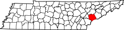
| County | Blount |
| Area | |
• Total | 2.49 sq mi (6.44 km2) |
| • Land | 2.49 sq mi (6.44 km2) |
| • Water | 0 sq mi (0.00 km2) |
| Elevation | 958 ft (292 m) |
| Population | |
• Total | 1,157 |
| • Density | 465.2/sq mi (179.61/km2) |
| Time zone | UTC-5 (Eastern (EST)) |
| • Summer (DST) | UTC-4 (EDT) |
| ZIP code | 37804 [4] |
| Area code | 865 |
| GNIS feature ID | 2586086 [2] |
Wildwood is an unincorporated community and census-designated place (CDP) in Blount County, Tennessee. As of the 2020 census, its population was 1,157. [5]
It is the location of Bethlehem Methodist Church, which is listed on the National Register of Historic Places. [6]