Wilkes-Barre and Hazleton Railway

Last updated
Wilkes-Barre and Hazleton Railway
The Street railway journal (1903) (14574023607).jpg
Overview
Other name(s)Cannon Ball
StatusConverted to road
Locale Luzerne County, Pennsylvania, USA
Termini
Service
Type Electric railway
SystemGuarded third rail
History
Opened1903 (1903)
Closed1933 (1933)
Technical
Line length29.70 mi (47.80 km)
Track gauge 1,435 mm (4 ft 8+12 in) standard gauge

The Wilkes-Barre and Hazleton Railway (also known as the Cannon Ball [1] ) was an electric railway in Luzerne County, Pennsylvania connecting the cities of Wilkes-Barre and Hazleton. It operated from 1903 to 1933 using a third rail and had no grade crossings. It was approximately thirty miles long and had one tunnel between Warrior Run and Nuangola through Penobscot Knob which Interstate 81 now crosses.

Contents

Prominent Hazleton banker and coal-mine owner Alvan Markle obtained a railway-company charter in 1892 and the Wilkes-Barre & Hazleton Railroad incorporated in New Jersey in 1899. Service opened from Hazleton to Ashley in 1903 but did not reach Wilkes-Barre until the 1907 completion of a 3rd-floor downtown station with a viaduct 34 feet in height and 1040 feet in length. General Electric had the contract for providing the electrification infrastructure. The completion of Route 309 greatly shortened the trip between Wilkes-Barre and Hazleton by road, leading to the Interstate Commerce Commission approval of abandonment in 1933. [1]

The Wilkes-Barre and Hazleton Railroad allowed faster travel between Hazleton and Wilkes-Barre than the 50-mile journey along the Lehigh Valley Railroad that was used previously. [1] The Wilkes-Barre and Hazleton Railway consisted of 24.76 miles of railway line for the Wilkes-Barre and Hazleton Railway Company, 3.3 miles of railway line for the Wilkes-Barre Terminal Railroad Company, and 1.64 miles of railway line for the Lehigh Traction Company. This totalled to 29.70 miles of railway line. [2]

History and operation

A completed order of cars for the Wilkes-Barre and Hazleton Railway Co. The street railway review (1891) (14757457804).jpg
A completed order of cars for the Wilkes-Barre and Hazleton Railway Co.

The charter for the Wilkes-Barre and Hazleton Railroad was granted on November 7, 1892. The railroad was incorporated in New Jersey in 1899. The railroad obtained a New Jersey charter on May 8, 1901. The railroad's power, generating station, sub-stations, and transmission lines were designed by the General Electric Company. In 1921, the PPL Corporation started to do the job of powering the railroad instead, as part of an attempt for the railroad to reduce its expenses. [1] The railroad stopped bringing in profit in the middle of the 1920s. [3] The railroad company defaulted its bonds in 1929. Henry S. Drikard, a businessman from Philadelphia, bought the Wilkes-Barre and Hazleton railroad company for $165,000 in February 1930. Briefly in 1932, several railbusses were used on the railroad. All service on the railroad stopped on September 17, 1933, following a ruling from the Pennsylvania Public Utility Commission, and power to the rail line was removed on October 3, 1933, after a final attempt to save the railroad from bankruptcy. [1]

Construction of the Wilkes-Barre and Hazleton Railroad started in 1901. Nine railroad bridges were required for the construction of the railroad. Most of the bridges were made of concrete, but some of the largest ones were not. The grade of the railroad on hills was 3%. The rails used weighed 95 pounds per yard. These rails were 30 feet (9.1 meters) long and on top of 8-inch by 6-inch ties. The ties for the third rails were 9 feet (2.7 meters) long. Wooden cars were used until 1916, when they were replaced by steel cars. [1]

The Wilkes-Barre and Hazleton Railroad opened for business in 1903. However, at that time it only ran from Hazleton to Ashley. In 1907, trains began running all the way to Wilkes-Barre via a 1040-foot long viaduct that was 34 feet (10 meters) high over the steam railroads of Wilkes-Barre. [1]

The Wilkes-Barre and Hazleton Railroad ran freight trains and passenger trains alternately. The railroad started operation at 6 a.m. and stopped operation at 2 a.m. [1]

Course

The Wilkes-Barre and Hazleton Railroad started in Hazleton and ran to West Hazleton on tracks belonging to the Lehigh Traction Company. From there, it went past Conyngham Gap, Butler Mountain, and Buck Mountain, before going down into the valley of Nescopeck Creek. Upon leaving the Nescopeck Creek valley, it went up Nescopeck Mountain via Nescopeck Pass, then descended into the valley of Big Wapwallopen Creek. Upon leaving the Big Wapwallopen Creek valley, the railroad went up Penobscot Mountain, tunneling through it at 1300 feet above sea level. The route then went down the mountain and past Sugar Gap and Solomon Creek to the community of Ashley. There the railroad connected to the tracks of the Wilkes-Barre Traction Company. The route was 26 miles long, but was later extended into downtown Wilkes-Barre via Georgetown. [1]

In Nuangola, a sub-station was built to supply the third rail of the Wilkes-Barre and Hazleton Railroad with 625 volts. [1] An additional sub station is in Georgetown, and the main power house was located at St. Johns, Pa. [4]

The crossing of the Wilkes-Barre and Hazleton Railway over Black Creek is a very large three-arch viaduct made of stone. Slightly over two miles north of the railroad's southern terminus, there is an interchange to the Lehigh Valley Railroad. This interchange is known as Oak Bur. The railroad also featured a horseshoe curve near Kis-Lyn. The railroad's Beisel Station was between 7.25 and 8.5 miles north of the southern terminus. Another station on the route was St. John's Station in the community of St. Johns. The railroad also had a station at the community of Blytheburn. The Wilkes-Barre and Hazleton Turnpike passed close to the railroad near the Yeager farms. There was a spur that goes towards the Ice Ponds. [1]

Financial information and leaders

The initial officers of the Wilkes-Barre and Hazleton Railroad were A. Markle, J.B. Price (the vice-president), E.S. Doud (the secretary), and N.C. Yost (the treasurer). The initial directors of the railroad were K.K. McLauren, A. Markle, W.B. Given, E.R. Payne, J.B. Price, A.A. Sterling, and Benjamin Reynolds. Two of Alvan Markle's sons, Alvan Markle Jr. and E.B. Markle, also held positions in the railway company. Alvan Markle Jr. joined the company in 1922 and became secretary and treasurer. E.B. Markle became the general manager, but took his father's position in 1928. [1]

Uses

When the Wilkes-Barre and Hazleton Railway was first opened, traffic along it mostly consisted of traffic going between Hazleton and Wilkes-Barre, although occasionally passengers got on at intermediate points. However, after the railroad was constructed, and due to its construction, some businesses began operation near the Pine View Ice Lakes along the route. The railroad also improved business for farmers near the community of Albert, who were able to send their milk to creameries in Hazleton. It also provided electricity for communities along the route. Additionally it transported materials for the mining industry, such as timber props, wedges, and sprags to Nuangola. The Wilkes-Barre and Hazleton Railway provided an easy way for hunters, fishermen, and sportsmen to access the mountainous countryside between Wilkes-Barre and Hazleton. Common places that such people frequented along the route included Nuangola Lake, Pine View Lake, and Lake Blytheburn. These areas gradually developed into villages. chickens were once exported from the railroad's Nuangola station. [1] Another use of the railway was to carry passengers from Hazleton to the Luzerne County Courthouse. [3]

Controversies and accidents

In 1907, a train running along the Wilkes-Barre and Hazleton Railway northward went off the tracks and crashed into a forest, catching fire. Several people were seriously injured during this event. This was the first accident on the railroad, but not the only one. Another accident occurred on one early afternoon when two interurban trains going in opposite directions on the railroad collided, causing a fire (due to broken electrical wiring), several serious injuries, and one death. This accident was primarily due to one of the trains leaving its station at an abnormal time. Another accident occurred near the Yeager farms, where a car fell from the Wilkes-Barre and Hazleton Turnpike and got hit by a train, which killed the car's seven passengers. In 1933, there were two train wrecks on the Wilkes-Barre and Hazleton Railway. [1]

The termination of use of the Wilkes-Barre and Hazleton Railway drew numerous protests from long-term users of the railroad. [1]

Records and legacy

The Wilkes-Barre and Hazleton Railroad was the earliest railroad to have a guarded third rail (guarding a third rail is done to protect it from the weather). [1] It was also one of the first interurban railroads to have no grade crossings and a fenced, private right-of-way. [1] A road called Henry Drive was later built on the old railroad bed. [1] Parts of the line in Hazleton Pa are still used by the present Norfolk Southern Ry. to serve the Valmont industrial Park, including the Black Creek viaduct.

Related Research Articles

<span class="mw-page-title-main">Luzerne County, Pennsylvania</span> County in Pennsylvania, United States

Luzerne County is a county in the Commonwealth of Pennsylvania. According to the United States Census Bureau, the county has a total area of 906 square miles (2,350 km2), of which 890 square miles (2,300 km2) is land and 16 square miles (41 km2) is water. It is Northeastern Pennsylvania's second-largest county by total area. As of the 2020 census, the population was 325,594, making it the most populous county in the northeastern part of the state. The county seat and largest city is Wilkes-Barre. Other populous communities include Hazleton, Kingston, Nanticoke, and Pittston. Luzerne County is included in the Scranton–Wilkes-Barre–Hazleton Metropolitan Statistical Area, which has a total population of 555,426 as of 2017.

<span class="mw-page-title-main">Mountain Top, Pennsylvania</span> Census-designated place in Pennsylvania, United States

Mountain Top is an unincorporated area and census-designated place (CDP) in Luzerne County, Pennsylvania, United States. As of the 2010 census, the CDP population was 10,982.

<span class="mw-page-title-main">Tamaqua, Pennsylvania</span> Borough in Pennsylvania, United States

Tamaqua is a borough in eastern Schuylkill County in the Coal Region of Pennsylvania, United States. It had a population of 6,934 as of the 2020 U.S. census.

The Lehigh Valley Railroad was a railroad built in the Northeastern United States to haul anthracite coal from the Coal Region in Pennsylvania. The railroad was authorized on April 21, 1846 for freight and transportation of passengers, goods, wares, merchandise and minerals in Pennsylvania and the railroad was incorporated and established on September 20, 1847 as the Delaware, Lehigh, Schuylkill and Susquehanna Railroad Company. On January 7, 1853, the railroad's name was changed to Lehigh Valley Railroad. It was sometimes known as the Route of the Black Diamond, named after the anthracite it transported. At the time, anthracite was transported by boat down the Lehigh River. The railroad ended operations in 1976 and merged into Conrail along with several northeastern railroads that same year.

<span class="mw-page-title-main">Pennsylvania Route 309</span> State highway in Pennsylvania, United States

Pennsylvania Route 309 is a state highway that runs for 134 miles (216 km) through eastern Pennsylvania. The route runs from an interchange between PA 611 and Cheltenham Avenue on the border of Philadelphia and Cheltenham Township north to an intersection with PA 29 in Bowman Creek, a village in Monroe Township in Wyoming County. The highway connects Philadelphia and its northern suburbs to Allentown and the Lehigh Valley, and Hazleton and Wilkes-Barre in the Wyoming Valley.

<span class="mw-page-title-main">Big Wapwallopen Creek</span> Creek in Pennsylvania, United States

Big Wapwallopen Creek is a tributary of the Susquehanna River in Luzerne County, Pennsylvania, in the United States. It is approximately 23 miles (37 km) long and flows through Bear Creek Township, Fairview Township, Rice Township, Wright Township, Dorrance Township, Hollenback Township, Nescopeck Township, and Conyngham Township. The watershed of the creek has an area of 53.2 square miles (138 km2). The creek has three named tributaries: Balliet Run, Watering Run, and Bow Creek. The creek is designated as a Coldwater Fishery and a Migratory Fishery and is also Class A Wild Trout Waters for part of its length. However, a portion is considered to be impaired by organic enrichment and/or low levels of dissolved oxygen and its pH ranges from moderately acidic to slightly alkaline.

<span class="mw-page-title-main">Reading Blue Mountain and Northern Railroad</span> Class II railroad in eastern Pennsylvania

The Reading Blue Mountain and Northern Railroad, sometimes shortened to Reading and Northern Railroad, is a regional railroad in eastern Pennsylvania. Its headquarters is in Port Clinton. The RBMN provides freight service on 300 miles (480 km) of track. Its mainline consists of the Reading Division between Reading and Packerton and the Lehigh Division between Lehighton and Dupont. Its main freight cargo is anthracite coal.

The Wilkes-Barre and Eastern Railroad (WB&E) was a railroad that operated in Pennsylvania from 1892 to 1939.

<span class="mw-page-title-main">Black Creek (Nescopeck Creek tributary)</span>

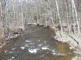
Black Creek is a long source tributary of Nescopeck Creek so part of the Susquehanna River drainage basin. It is also the second & longer stream of the same name recognized by the USGS GNIS system in Luzerne County, Pennsylvania, in the United States—compared to the Black Creek beyond the ridgeline of the drainage divide, so in the Lehigh River valley and Carbon County. The headwaters of both Black Creeks in Luzerne county are only a few miles apart, and both valleys were traversed by the Lausanne-Nescopeck Turnpike in the first half of the 19th-century.

<span class="mw-page-title-main">Schuylkill Branch</span> Former railroad line in Pennsylvania

The Schuylkill Branch was a rail line owned and operated by the former Pennsylvania Railroad (PRR) in the U.S. state of Pennsylvania. The line ran from the Philadelphia to Harrisburg Main Line at 52nd Street in Philadelphia north via Norristown, Reading, and Pottsville to Delano Junction. From Delano Junction, the PRR had trackage rights over the Lehigh Valley Railroad's Hazleton Branch and Tomhicken Branch to Tomhicken, where the PRR's Catawissa Branch began. In conjunction with the Catawissa Branch, Nescopeck Branch, and Wilkes-Barre Branch, the Schuylkill Branch gave the PRR a direct line from Philadelphia to Wilkes-Barre.

<span class="mw-page-title-main">Lehigh Gorge State Park</span>

Lehigh Gorge State Park is a 4,548 acres (1,841 ha) Pennsylvania state park in Luzerne and Carbon Counties, Pennsylvania. The park encompasses a gorge, which stretches along the Lehigh River from a U.S. Army Corps of Engineers flood control dam in Luzerne County to Jim Thorpe in Carbon County. The primary recreational activity at Lehigh Gorge State Park is white water rafting.

The Danville, Hazleton and Wilkes-Barre Railroad, also called the D.H. & W.B. Railroad, was a railroad in northeastern Pennsylvania. It ran from Sunbury to Tomhicken, a total of 43.44 miles plus 10.1 miles of branch lines, making the whole railroad 53.54 miles long. The railroad was completed in 1870. As of 2010, the Danville, Hazleton and Willkes-Barre Railroad tracks belong to the Pennsylvania Railroad. The railroad's gauge was 4 ft 9 in.

<span class="mw-page-title-main">Mountain Top Yard</span>

Mountain Top yard or Penobscot yard is a rail yard in Mountain Top, Pennsylvania. It was built by the Lehigh Coal & Navigation Company (LC&N) in response to an 1837 bill authorizing a right of way and was established by 1840, at least as a construction camp for the Ashley Planes, in support of the construction of the Lehigh and Susquehanna Railroad trackage and operations to join the northern Anthracite Coal Region from barge loading docks along the Susquehanna in Pittston, in the Wyoming Valley, with the Lehigh Canal.

<span class="mw-page-title-main">Little Wapwallopen Creek</span> Tributary of the Susquehanna River

Little Wapwallopen Creek is a tributary of the Susquehanna River in Luzerne County, Pennsylvania, in the United States. It is approximately 17 miles (27 km) long and flows through Rice Township, Dorrance Township, Conyngham Township, and Hollenback Township. The watershed of the creek has an area of 39.5 square miles (102 km2). The creek is designated as a Coldwater Fishery and a Migratory Fishery and is not considered to be impaired. It has two named tributaries: Pond Creek and Nuangola Outlet. Wild trout naturally reproduce in the creek.

<span class="mw-page-title-main">Lehigh Line (Norfolk Southern)</span> Railroad line in central New Jersey and northeastern Pennsylvania

The Lehigh Line is a railroad line in central New Jersey, Northeastern Pennsylvania, and the Lehigh Valley region of eastern Pennsylvania. It is owned and operated by the Norfolk Southern Railway. The line runs west from the vicinity of the Port of New York and New Jersey via Conrail's Lehigh Line to the Susquehanna River valley at the south end of the Wyoming Valley Coal Region. Administratively, it is part of Norfolk Southern's Keystone Division and is part of the Crescent Corridor. As of 2021 the line is freight-only, although there are perennial proposals to restore passenger service over all or part of the line.

<span class="mw-page-title-main">Alvan Markle</span> American banker

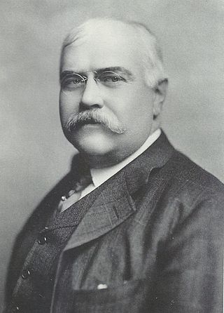
Alvan Markle was an American banker, businessman, engineer, and inventor based in Hazleton, Pennsylvania. He was the son of George Bushar Markle (1827–1888), a rural carpenter and ingenious inventor who became a successful banker and coal operator. Alvan was the brother of John Markle, who established the John and Mary Markle Foundation. Alvan, his father, and his brothers were instrumental in making Hazleton a financial and industrial hub through their inventions and their initiative in establishing regional transportation systems, electric power, extraction technologies, as well as social and educational institutions.

<span class="mw-page-title-main">Nuangola Outlet</span> River

Nuangola Outlet is a tributary of Little Wapwallopen Creek in Luzerne County, Pennsylvania, in the United States. It is approximately 1.8 miles (2.9 km) long and flows through Rice Township. The watershed of the stream has an area of 2.35 square miles (6.1 km2). Wisconsinan Till and bedrock consisting of sandstone, shale, conglomerate, and coal occur in the watershed. There are also several lakes and patches of wetland. The stream was observed to have "excellent" water quality in the 1970s.

<span class="mw-page-title-main">Haystack Mountain (Pennsylvania)</span>

Haystack Mountain (Pennsylvania), is an otherwise non-descript 1871 ft peak forming the steep southwestern faces of the Solomon Gap mountain pass's saddle connecting and dividing the Wyoming Valley from the Lehigh Valley.

References

  1. 1 2 3 4 5 6 7 8 9 10 11 12 13 14 15 16 17 18 Daniel Thole, WB&H (PDF), Mountain Top Historical Society, retrieved January 5, 2012
  2. Pennsylvania (Dept. of Internal Affairs) (December 3, 1915), Annual Report of the Bureau of Railways, Part 4 Railroad, Canal, Navigation, Telegraph & Telephone Companies, Harrisburg, Pennsylvania: Commonwealth of Pennsylvania
  3. 1 2 Pasco L. Schiavo (July 2011), Betrayal and Deliverance of a Community, Dorrance Publishing Co., ISBN   978-1434910288
  4. Edwin Jay Quinby (1972), Wilkes-Barre and Hazleton Railway, Fredon, New Jersey: Model Craftsman Publishing Corporation, ISBN   978-0911868777