Willets, North Carolina

Last updated
Willets, North Carolina
Mount Pleasant Baptist Church, Willets, NC.jpg
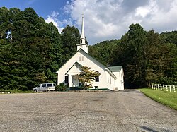
Mount Pleasant Baptist Church, located at Willets
USA North Carolina location map.svg
Red pog.svg
Willets
Usa edcp location map.svg
Red pog.svg
Willets
Coordinates: 35°24′42″N83°06′56″W / 35.41167°N 83.11556°W / 35.41167; -83.11556 Coordinates: 35°24′42″N83°06′56″W / 35.41167°N 83.11556°W / 35.41167; -83.11556
Country United States
State North Carolina
County Jackson
Elevation
2,690 ft (820 m)
Time zone UTC-5 (Eastern (EST))
  Summer (DST) UTC-4 (EDT)
Area code(s) 828
GNIS feature ID996296 [1]

Willets is an unincorporated community in Jackson County, North Carolina, United States. Willets is located along U.S. Route 74, west of Balsam and east of Sylva. It is home to the Balsam-Willets-Ochre Hill fire department, a church, and many homes. It was a thriving unincorporated town along the Murphy Branch of the Western North Carolina Railroad, but seriously declined during the Great Depression in the 1930s, consolidations of the schools in the Scott Creek Township in 1951, and the widening/straightening of US 23 in the early 1950s and early 1970s. Today it is a tiny bedroom community for the larger population centers of Waynesville and Sylva.

History

The old Willets Graded School in 1909 Willets School.jpg
The old Willets Graded School in 1909
The Willets Depot in the 1890s, when it was known as Hall's Station/Hall's Siding. Hall's Siding Station.jpeg
The Willets Depot in the 1890s, when it was known as Hall's Station/Hall's Siding.

A post office called Willets was established in 1903, and remained in operation until 1934. [2] The community was named for A. P. Willets, the owner of a local sawmill. [3]

Related Research Articles

Jackson County, North Carolina County in North Carolina, United States

Jackson County is a county located in the far southwest of the U.S. state of North Carolina. As of the 2010 census, the population was 40,271. Since 1913 its county seat has been Sylva, which replaced Webster.

Haywood County, North Carolina County in North Carolina, United States

Haywood County is a county located in the U.S. state of North Carolina. As of the 2010 census, the population was 59,036. The county seat and its largest city is Waynesville. Haywood County is part of the Asheville, NC Metropolitan Statistical Area.

Waynesville, North Carolina Town in North Carolina, United States

Waynesville is a town in and the county seat of Haywood County, North Carolina, United States. It is the largest town in Haywood County and the largest in western North Carolina west of Asheville. Waynesville is located about 30 miles (50 km) southwest of Asheville between the Great Smoky and Blue Ridge mountains.

Cashiers, North Carolina Unincorporated village in Jackson County, North Carolina

Cashiers is a census-designated place (CDP) and unincorporated village located in southern Jackson County, North Carolina, United States. As of the 2010 United States census, the community had a total population of 157. Cashiers is pronounced KASH-erz locally, and is one of several communities in the area popular with tourists and owners of vacation homes.

Cullowhee, North Carolina Census-designated place in North Carolina, United States

Cullowhee is a census-designated place (CDP) in Jackson County, North Carolina, United States. It is located on the Tuckasegee River, and the permanent population was 6,228 as of the 2010 census.

Dillsboro, North Carolina Town in North Carolina, United States

Dillsboro is a town in Jackson County, North Carolina, United States. The population was 232 at the 2010 census.

Sylva, North Carolina Town in North Carolina, United States

Sylva is an incorporated town located in central Jackson County, in the Plott Balsam Mountains of Western North Carolina, United States of America. As of the 2010 census, the town had a total population of 2,588. It is the county seat, taking over the role from nearby Webster in 1913.

Murphy Branch

The historically important Murphy Branch is the westernmost part of what was the Western North Carolina Railroad, later the Richmond and Danville, Southern Railway, the Norfolk Southern Railway (NS) and today the Blue Ridge Southern Railroad. The branch runs between Asheville, North Carolina in the east and Murphy in the west. It roughly follows I-40 from Asheville to Canton and US Route 74, also known as the Great Smoky Mountains Expressway, from Canton to Murphy.

The Great Smoky Mountains Expressway is a four-lane divided highway that serves as the main east–west corridor through Southwestern North Carolina; connecting the towns of Bryson City, Sylva and Waynesville to Interstate 40. Its establishment and funding was made possible by the Appalachian Development Highway System (ADHS), designed to generate economic development in previously isolated areas, supplement the interstate system and provide access to areas within the region as well as to markets in the rest of the nation.

Balsam Gap

Balsam Gap is a mountain pass between the Plott Balsam Range to the northwest and the Great Balsam Mountains to the southeast on the county line dividing Haywood and Jackson counties in the U.S. state of North Carolina.

Balsam, North Carolina Place in North Carolina, United States

Balsam is an unincorporated community located in the Scott Creek township of Jackson County, in the Blue Ridge Mountains of Western North Carolina, United States. As of the 2000 census, the town had a total population of 49. There is one United States Post Office in the town. The Zip Code is 28707.

Plott Balsams Mountain range in North Carolina, United States

The Plott Balsams are a mountain range in western North Carolina, in the southeastern United States. They are part of the Blue Ridge Mountain Province of the Southern Appalachian Mountains. The Plott Balsams stretch from the city of Sylva in the Tuckasegee River valley to the southwest to Maggie Valley in the northeast. The Great Smoky Mountains border the Plott Balsams to the north and the Great Balsam Mountains border the range to the south. The range comprises parts of Jackson County and Haywood County.

U.S. Route 23 in North Carolina is a north–south United States highway that runs for 106 miles (171 km) from the Georgia state line, near Dillard, to the Tennessee state line, near Flag Pond.

Tuckasegee, named after the historic Cherokee town of that name located near here, is an unincorporated community in Jackson County, North Carolina, United States. It followed the earlier Cherokee town as developing on the upper Tuckaseegee River, at the confluence of its East and West forks.

Jackson County Public Schools is a public school district serving Jackson County, North Carolina, US. It is headquartered in the county seat of Sylva. The Jackson County School system is unique in the way that is still has a K–8 system with combined elementary and middle schools, with one central high school and one combined K–12 elementary/middle/high school. The county school system has eight schools, all with different histories and stories behind why they are the way they are today. The school system includes four kindergarten-through-8th-grade schools, two kindergarten-through-12th-grade schools, one traditional 9th-through-12th-grade high school, and one alternative 9th-through-12th-grade high school early college.

Savannah is an unincorporated community in Jackson County, North Carolina, United States. Savannah is located along North Carolina Highway 116 and US 441, south of Dillsboro and southeast of Webster. It has its own fire department, a community center, and a couple of businesses lining US 441 and NC 116, and little else except homes.

Addie is an unincorporated community in Jackson County, North Carolina, United States. Addie is located along U.S. Route 74, west of Willets-Ochre Hill and east of Sylva. The Jackson County School of Alternatives and Scotts Creek Elementary School are located here. T&S Hardwoods operates a lumber yard here, adjacent to the railroad that runs through the area.

Beta is an unincorporated community in Jackson County, North Carolina, United States. Beta is located along U.S. Route 74, west of Addie and east of Sylva.

Saunook is an unincorporated community in Haywood County, North Carolina, United States. Saunook is located along US 74, West of Waynesville and East of Balsam.

Norton is an unincorporated community in Jackson County, in the U.S. state of North Carolina.

References

  1. "US Board on Geographic Names". United States Geological Survey. 2007-10-25. Retrieved 2008-01-31.
  2. "Jackson County". Jim Forte Postal History. Retrieved 23 May 2015.
  3. McRorie, J.D. (Aug 17, 1978). "Knowing Jackson...Names Chosen Informally". The Sylva Herald and Ruralite. p. 2. Retrieved 23 May 2015.