The Williamsport and North Branch Railroad was a short line that operated in north-central Pennsylvania between 1872 and 1937. After a long struggle to finance its construction, it was completed in 1893. It derived most of its freight revenue from logging and to a certain extent from anthracite coal traffic. It also carried many passengers to mountain resorts in Sullivan County, Pennsylvania. With the decline of the logging industry and increased accessibility of the region by automobile in the 1910s and 1920s, the railroad's business rapidly declined. The economic blow of the Great Depression proved insurmountable, and it was abandoned as unprofitable in 1937.
The railroad was originally chartered as the Muncy Creek Railway on May 21, 1864. It was intended to provide a railroad outlet for Laporte, the newly established county seat of Sullivan County, via the valley of Muncy Creek.[1] Some surveying, and possibly even grading, was done, but the new corporation ran out of money around 1867 and remained quiescent for several years. Interest in the railroad did not resume until 1871, when the Catawissa Railroad, later part of the Reading system, completed its line up the east bank of the West Branch Susquehanna River, passing through Muncy and Halls. Muncy, near the mouth of Muncy Creek, was an established town and would have been the logical terminus of the railroad. However, residents of Muncy feared the railroad would compete with an existing plank road to Hughesville and refused it permission to enter the town. Accordingly, the railroad was built from Halls to Hughesville in 1872, but money for further work was again lacking.[2] The railroad was extended to Picture Rocks in 1875 using wooden rails to save money. However, the wooden rails could not withstand the weight of trains and the extension was abandoned in early 1876.[3] The Muncy Creek Railway continued to struggle along until 1881, when the bondholders petitioned to have it placed in receivership. It was foreclosed on August 9, 1882, and reorganized on September 1, 1882 as the Williamsport and North Branch Railroad.[3]
The new owners still intended to extend the railroad towards Laporte and the coalfield at Bernice, but this could only be accomplished in slow stages. The track from Halls to Hughesville was rebuilt to make up for the deferred maintenance of previous years, and in late 1883, construction north and east began again.[3] The new line followed a different route from the unsuccessful wooden-railed extension, following the west side of Muncy Creek through Tivoli up to Glen Mawr, which was reached in 1884. There was a picnic grove at Tivoli which was the destination of summer excursions, and a stage connection to the resort of Eagles Mere, then called Lewis Lake.[4]
Extension of the line continued. At Glen Mawr, the railroad crossed Muncy Creek and followed its east bank up to Sonestown, which it reached in 1885, and Nordmont, where it ended in October 1886. Here the railroad's expansion ceased again, but the sawmills and tanneries of the Muncy Valley provided the revenue to keep it solvent.
In the late 1880s, the Pennsylvania Railroad took an interest in the W&NB as a means of reaching the Bernice coalfields. The State Line and Sullivan Railroad, a subsidiary of the Lehigh Valley, had already reached the area, and the Bloomsburg and Sullivan Railroad, backed by the Reading interest, had been chartered in 1883 to reach Bernice from the south via Fishing Creek. The PRR backed a new syndicate which took over the W&NB in 1888, and named George Sanderson president. However, the PRR's interest in the W&NB quickly waned, especially after the Bloomsburg & Sullivan's construction halted in Jamison City, never to reach Bernice.[4] The failure of Sanderson's bank in 1891 resulted in the transfer of his investment in the W&NB to his creditors, including John Satterfield; Satterfield now became vice-president and Henry C. McCormick president of the railroad. Satterfield was determined to complete the railroad, and after raising money and surveying, construction began in 1892. At Nordmont, the railroad crossed Muncy Creek on a horseshoe curve and began climbing up the other side of the valley, then turning up Deep Hollow and crossing over into the Loyalsock Creek watershed. The new line passed Lake Mokoma and Laporte and descended high on the east side of the Mill Creek valley, turning and descending along the Loyalsock to Ringdale. The line from Ringdale to the summit between Loyalsock and Muncy creeks was built on a 1% grade to facilitate handling heavy coal trains from Bernice. At Ringdale, the line crossed the Loyalsock on a high trestle, 476 feet (145m) long, and ran up Birch Creek. The line forked at Birch Creek Junction, with one branch going up a tributary of Birch Creek to a junction with the State Line & Sullivan at Dohm's Summit, while another followed Birch Creek to join the State Line and Sullivan at Bernice.[5]
John Satterfield, vice-president of the W&NB
The line was completed into Laporte in August 1893, and to Dohm's Summit in September. The latter was renamed Satterfield in honor of the promoter who had completed the W&NB. Construction of a depot at Satterfield began in October, but a dispute with the Lehigh Valley over property ownership resulted in its demolition, and it was relocated in November. The W&NB did obtain trackage rights over the State Line & Sullivan to Towanda for its passenger trains.[6] The branch to Bernice was finished in 1894.[7]
Business of the railroad
The finished W&NB enjoyed considerable business, both passenger and freight. Along the southern portion of the line, three furniture factories operated in the lower Muncy Valley.[8] Above Picture Rocks was the Lyon sawmill, the largest sawmill on Muncy Creek. Logs were floated down the creek to the mill, and it shipped finished lumber over the railroad. Smaller sawmills were common along the line north of Picture Rocks.[9] Tanneries at Muncy Valley and Laporte came under the control of the Union Tanning Company (a subsidiary of the United States Leather Company) in 1893,[10] using hemlock bark supplied by logging. In the late 1890s, a chemical company was built at Nordmont which made charcoal, acetic acid, and wood alcohol from wood.[11] Attempts to develop Lake Mokoma for ice harvesting were largely unsuccessful. Finally, anthracite coal mined around Bernice supplied some of the railroad's freight traffic.[7]
Passenger service was also important to the railroad's revenue. Several hotels around Highland Lake were connected by stage to the railroad's station at Chamouni (later renamed Essick and Tivoli).[10] The opening of the narrow gaugeEagles Mere Railroad on July 1, 1892 provided additional passenger traffic.[12] The narrow gauge interchanged with the W&NB at Sonestown, providing passenger service to the many hotels at the resort of Eagles Mere.[11]
Prosperity
The station at Sonestown. The W&NB once served a clothespin factory and a stave mill here.
Extension to the coal fields did not result in immediate prosperity. Despite an increase in traffic, the additional cost of extending the railroad resulted in interest charges that dragged the railroad down. McCormick resigned as president in 1896, and an economic downturn in 1897 brought the railroad into insolvency. The owners decided to sell out to a group of New York financiers and local businesspeople, and B. Harvey Welch, a native of Hughesville, became president. This transaction eliminated the bond interest and put the railroad back on a reasonably sound financial footing.[13]
After 1900, a lime-burning business began to develop on the south end of the line, using local limestone deposits and coal shipped south from Bernice.[14] In 1901, the Eagles Mere Railroad was leased to the W&NB for $5,000 a year.[15] This proved to be a fortunate decision, for in that same year, Union Tanning decided to log large tracts of forest to the north and west of the line.[16] Charles W. Sones contracted to do the logging, and built a sawmill at Kettle Creek, and a logging railroad to connect it with Eagles Mere. The lumber was shipped down the Eagles Mere Railroad to Sonestown and then over the W&NB; a narrow gauge rail was laid from Sonestown to Muncy Valley to allow Eagles Mere trains to haul bark directly to the tannery there.[15] About this time, the Northern Anthracite Company built its Murraycoal breaker two miles west of Bernice. The W&NB was given exclusive rights to serve it, operating via trackage rights over the Lehigh Valley to a new spur to the mine.[16] At 169 feet (52m) high, the breaker was the tallest structure in central Pennsylvania.[17] When the Coal Strike of 1902 paralyzed many of the mines on the Reading, Northern Anthracite experienced a boom in business, and for a short while, the W&NB was shipping a thousand tons of coal per day to Halls for interchange with the Reading.[16]
The rosy prospects of coal traffic proved illusory, however. After the strike ended, coal traffic rapidly fell off.[16] A further blow occurred in 1906, when Sones' logging railroad (incorporated in 1904 as the Susquehanna and Eagles Mere Railroad) was extended to Masten and a connection with the Susquehanna and New York Railroad, owned by Union Tanning. The Laporte tannery closed about this time, and Sones' lumber traffic was diverted to move through Masten rather than Sonestown. The closing of the Muncy Valley Tannery in 1908 effectively removed Union Tanning's traffic from the railroad. However, wood products traffic was still generated at Nordmont. Sutton Peck Chemical had built a standard gauge logging railroad up Cherry Run and down Painter Run in 1900. Sutton Peck became Nordmont Chemical in 1904, and in 1908, it removed the Cherry Run–Painter Run line. A new line was incorporated by the chemical company as the Wyoming and Sullivan Railroad, and built several miles up Muncy Creek to continue supplying wood to Nordmont Chemical.[18]
The W&NB's most profitable year was in 1906, when it netted $15,000.[18] Thereafter, it fluctuated between surplus and deficit until 1912, the last year it showed a profit. Most local industries, such as logging, tanning and agriculture, declined through the 1910s, with only coal shipments remaining dependable. The only significant industrial development was the opening of the Big Run Manufacturing Company's stave mill at Sonestown in 1914.[19] Big Run Manufacturing was a project of local loggers, including Col. R. Bruce Ricketts. The company laid a standard gauge rail a short distance on the Eagles Mere Railroad, and then turned up Big Run to collect timber. This line was removed around 1917 or 1918, and a new line was laid on part of the old Nordmont Chemical grade from Nordmont up Cherry Run. Logging trains originating on this line operated over the W&NB from Nordmont to Sonestown until 1922, when the stave mill was closed and its logging line abandoned.[20]
The W&NB went into receivership in 1917 due to its inability to pay off its bonded interest, and the lease of the Eagles Mere Railroad was canceled in 1920. The W&NB was reorganized as the Williamsport and North Branch Railway on May 1, 1921.[19] In addition to the closing of the Sonestown stave mill, Nordmont Chemical sold out to Charles Sones in 1924. He closed the factory, replaced it with a sawmill, and continued to haul logs on the Wyoming & Sullivan until 1930. With local traffic falling off, the W&NB depended on the small amount of bridge traffic allotted it by the ICC to help sustain it. It was only allowed freight traveling over the Grand Trunk Railway and the Lehigh Valley which was destined for the Reading. In practice, this amounted largely to automobiles and grain.[20]
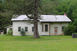
Pennsdale, one of three remaining stations from the railroad.
It was the Great Depression that ultimately finished off the Williamsport and North Branch. The Eagles Mere Railroad had been abandoned in 1926 after flood damage, but it no longer supplied any significant traffic for the W&NB. After 1930, the logging and wood products industry had essentially shut down, leaving only the coal mines as regular generators of freight traffic north of Picture Rocks. The furniture factories lower in the valley also suffered during the Depression.[21] During the 1930s, the railroad just scraped along, able to pay its operating expenses but unable to maintain track or equipment. By 1937, it was in so decrepit a state that the owners decided to abandon it. The last train ran on October 11, 1937, and tracks were removed by summer 1938.[22]
Little remains of the railroad, although the Pennsdale[23] and Sonestown stations are now private residences, the Nordmont station stands vacant,[24] and part of the grade has been incorporated into the Loyalsock Trail.
Sullivan County is a county located in the U.S. state of Pennsylvania. As of the 2010 census, the population was 6,428, making it the second-least populous county in Pennsylvania. Its county seat is Laporte. The county was created on March 15, 1847, from part of Lycoming County and named for Charles C. Sullivan, leader of the Pennsylvania Senate at that time.
Lycoming County is a county located in the U.S. Commonwealth of Pennsylvania. As of the 2010 census, the population was 116,111. Its county seat is Williamsport.
Loyalsock Township is a township in Lycoming County, Pennsylvania, United States. The population was 11,026 at the 2010 census. It is part of the Williamsport, Pennsylvania Metropolitan Statistical Area. It is the second largest municipality in Lycoming County, in terms of population, behind the county seat Williamsport.
Plunketts Creek Township is a township in Lycoming County, Pennsylvania, United States. It includes the villages of Barbours and Proctor. The population was 771 at the 2000 census. It is part of the Williamsport, Pennsylvania Metropolitan Statistical Area.
Laporte is a borough in Sullivan County, Pennsylvania, United States. The population was 316 at the 2010 census. It is the county seat of Sullivan County. Laporte is surrounded by Laporte Township. It was named for John Laporte. It is the smallest county seat in Pennsylvania by population, and in 1969 was one of the two smallest in the United States.
The West Branch Susquehanna River is one of the two principal branches, along with the North Branch, of the Susquehanna River in the northeastern United States. The North Branch, which rises in upstate New York, is generally regarded as the extension of the main branch, with the shorter West Branch being its principal tributary. The West Branch, which is 243 miles (391 km) long, is entirely within the state of Pennsylvania, draining a large mountainous area within the Allegheny Plateau in the western part of the state. Along most of its course it meanders along mountain ridges and through water gaps, forming a large zigzag arc through central Pennsylvania around the north end of the Allegheny Ridge. In colonial times the river provided an important water route to the Ohio River valley. In the 18th century, its lower valley became a significant industrial heartland of Pennsylvania. In the 20th century, the upper reaches of the West Branch turned a yellow/orange color due to sulfurous drainage from nearby and abandoned deep bituminous coal mines.
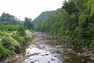
Muncy Creek is a tributary of the West Branch Susquehanna River in Sullivan County and Lycoming County, at Pennsylvania, in the United States. It is approximately 34.5 miles (55.5 km) long. The watershed of the creek has an area of 216 square miles (560 km2). The creek's discharge averages 49 cubic feet per second (1.4 m3/s) at Sonestown, but can be up to a thousand times higher at Muncy. The headwaters of the creek are on the Allegheny Plateau. Rock formations in the watershed include the Chemung Formation and the Catskill Formation.
Worlds End State Park is a 780-acre (316 ha) Pennsylvania state park in Sullivan County, Pennsylvania, in the United States. The park, nearly surrounded by Loyalsock State Forest, is in the Loyalsock Creek valley on Pennsylvania Route 154, in Forks and Shrewsbury Townships southeast of the borough of Forksville. The name Worlds End has been used since at least 1872, but its origins are uncertain. Although it was founded as Worlds End State Forest Park by Governor Gifford Pinchot in 1932, the park was officially known as Whirls End State Forest Park from 1936 to 1943.
Loyalsock Creek is a 64-mile-long (103 km) tributary of the West Branch Susquehanna River located chiefly in Sullivan and Lycoming counties in Pennsylvania in the United States. As the crow flies, Lycoming County is about 130 miles (209 km) northwest of Philadelphia and 165 miles (266 km) east-northeast of Pittsburgh.
The Loyalsock Trail (LT) is a 59.2 mi (95.3 km) hiking trail along Loyalsock Creek in Lycoming and Sullivan counties in north central Pennsylvania in the United States.
The Lycoming Valley Railroad is a short line that operates 38 miles (61 km) of track in Lycoming and Clinton counties in Pennsylvania in the United States. It is part of the North Shore Railroad System.
The West Branch Susquehanna Valley of central Pennsylvania, United States, in the Ridge-and-valley Appalachians, is the low-lying area draining into the West Branch Susquehanna River southeast of the Allegheny Front, northeast of the Bald Eagle Valley, southwest of the Wyoming Valley and north of the water gap formed between Shamokin Mountain and Montour Ridge.
This article details a history of Lycoming County, Pennsylvania.
Plunketts Creek is an approximately 6.2-mile-long (10 km) tributary of Loyalsock Creek in Lycoming and Sullivan counties in the U.S. state of Pennsylvania. Two unincorporated villages and a hamlet are on the creek, and its watershed drains 23.6 square miles (61 km2) in parts of five townships. The creek is a part of the Chesapeake Bay drainage basin via Loyalsock Creek and the West Branch Susquehanna and Susquehanna Rivers.
The Old Loggers Path (OLP) is a 27.1 mi (43.6 km) loop hiking trail in Lycoming County in north-central Pennsylvania in the United States. Marked with international orange blazes, the Old Loggers Path is located entirely within the Loyalsock State Forest. Most hikers take two and a half to three days and two nights to complete the Old Loggers Path, making it popular for weekend hikes. Highlights of the trail include waterfalls, several scenic streams and creeks, and panoramic vistas.
The Susquehanna and Eagles Mere Railroad was a logging railroad operating from 1902 to 1930 in Sullivan and Lycoming Counties in Pennsylvania in the United States.
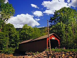
The Sonestown Covered Bridge is a covered bridge over Muncy Creek in Davidson Township, Sullivan County, Pennsylvania built around 1850. It is 110 ft (34 m) long and was placed on the National Register of Historic Places (NRHP) in 1980. It is named for the nearby unincorporated village of Sonestown in Davidson Township, and is also known as the Davidson Covered Bridge. It was built to provide access to a grist mill which operated until the early 20th century.
Plunketts Creek Bridge No. 3 was a rubble masonry stone arch bridge over Plunketts Creek in Plunketts Creek Township, Lycoming County in the U.S. state of Pennsylvania. It was built between 1840 and 1875, probably closer to 1840, when the road along the creek between the unincorporated villages of Barbours and Proctor was constructed. Going upstream from the mouth, the bridge was the third to cross the creek, hence its name.
The Bloomsburg and Sullivan Railroad, (e.1888-d.1972) also called the B & S Railroad, was a long-lived independent shortline railroad that existed under that name operating independently from 1888 to 1928 in Columbia County, Pennsylvania, when it was made a subsidiary of the Reading Company, which closed it in 1972. The shortline railroad was 29 miles long, running from south of Bloomsburg, Pennsylvania past the town, then northwards to Jamison City, Pennsylvania, with 4.45 miles of yard tracks. The Bloomsburg and Sullivan Railroad was one of five railroads serving Bloomsburg near the turn of the 20th century. The Bloomsburg and Sullivan Railroad Company's headquarters was in Williamsport, Pennsylvania, and the managers of the company were James Corcoran and Thomas Wheeler. The Bloomsburg and Sullivan Railroad owned five locomotives and seven cars in 1917.
The Eagles Mere Railroad was a 3 ft narrow gauge railroad in Sullivan County, Pennsylvania, built in 1892 to connect the resort of Eagles Mere with the standard gauge Williamsport and North Branch Railroad at Sonestown, 8 miles (13 km) away by rail. It was leased to the connecting Williamsport & North Branch in 1901, which continued to operate it as a narrow gauge, and extended it in 1902–3 to Eagles Mere Park and a connection with the narrow gauge Susquehanna and Eagles Mere Railroad, a logging railroad. The line went through a receivership and reorganization in 1911–2, and a second in 1920, due to increasing competition with automobiles for traffic to Eagles Mere. It was reorganized again in 1922 as the Eagles Mere Railway, operating independently of the W&NB, but ended passenger service in 1923 and freight service in 1927. It was abandoned in 1928.
References
Taber, Thomas T. III (1995), Muncy Valley Lifeline, Muncy, Pennsylvania: Thomas T. Taber III
This page is based on this Wikipedia article Text is available under the CC BY-SA 4.0 license; additional terms may apply. Images, videos and audio are available under their respective licenses.