Picture Rocks, Pennsylvania

Last updated
Picture Rocks, Pennsylvania
Picture Rocks, Pennsylvania 1.jpg
Heading north on US Route 220 into Picture Rocks
Lycoming County Pennsylvania Incorporated and Unincorporated areas Picture Rocks Highlighted.svg
Location of Picture Rocks in Lycoming County, Pennsylvania.
Map of Pennsylvania highlighting Lycoming County.svg
Map of Pennsylvania highlighting Lycoming County
Coordinates: 41°16′48″N76°42′42″W / 41.28000°N 76.71167°W / 41.28000; -76.71167
Country United States
State Pennsylvania
County Lycoming
Settled1848
Incorporated1857
Area
[1]
  Total1.00 sq mi (2.59 km2)
  Land0.97 sq mi (2.52 km2)
  Water0.03 sq mi (0.07 km2)
Elevation
[2]
646 ft (197 m)
Population
 (2020) [3]
  Total643
  Density660.16/sq mi (254.77/km2)
Time zone UTC-5 (Eastern (EST))
  Summer (DST) UTC-4 (EDT)
ZIP code
17762
Area code 570
FIPS code 42-60136 [4]
GNIS feature ID1193116 [2]
Website https://picturerocksborough.com

Picture Rocks is a borough in Lycoming County, Pennsylvania, United States. The 2020 census measured the population at 640. [5] It is part of the Williamsport, Pennsylvania Metropolitan Statistical Area.

Contents

Notable person

Picture Rocks is the birthplace of Warren Sprout, who won a shooting gold medal at the 1912 Olympics.

History

Picture Rocks was incorporated as a borough on September 27, 1875 from land formerly included in Wolf Township. However, its recorded history began a century earlier. [6] The earliest settlers arrived in 1773 and observed Indian pictographs (no longer extant) in the Muncy Creek valley. The borough occupies the site of a Munsee Indian village, evidenced by arrowheads and other relics found in the vicinity of the creek.

The borough hall in Picture Rocks Picture Rocks, Pennyslvania 2.jpg
The borough hall in Picture Rocks

The Province of Pennsylvania issued the first warrant for property in the Picture Rocks area to Henry Rody on June 3, 1773. The land remained largely undeveloped passing through several hands until it was sold in 1848 to A. R. Sprout and Amos Burrows. The two founded Picture Rocks. Sprout and Burrows cleared the land of the rocks, logs and brush. They also rebuilt an abandoned sawmill and established a factory that manufactured sashes, doors, and window blinds. This factory, the first of its kind in the area, caused a stir among local carpenters who believed that the ready made building materials would curtail their craft. The factory was later used by the Burrows Brothers Furniture Company before becoming the Handle and Excelsior Company. Another factory, located at the present intersection of U.S. Route 220 and Factory Street, manufactured ladders. Picture Rocks continues as a wood processing center. [7]

The town grew as other manufacturers arrived to harness water power provided by Muncy Creek. The prohibitionist organizers of the town required persons purchasing lots in Picture Rocks to sign an agreement stating that they would not open a saloon or engage in the trafficking of liquor. The borough remains a dry municipality. [8]

The Baptists of Picture Rocks organized an 1840 meeting at the school house. A traveling minister arrived in Picture Rocks one Saturday evening and found the school to be unfit for Sunday gatherings. After preaching the following morning, he rallied the members of the congregation to the cause of building a proper house of worship. Under the guidance of their new pastor, the members of the Baptist Church built a log church. Twenty-five years later the congregation replaced it with a larger facility.

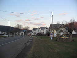
At the time of the borough's creation, Center Street was the primary thoroughfare. The stately homes built by the Burrows and Sprout families remained along Center Street and were identified by their square shape with low pitched roofs some with a widow's watch.

Borough resident John Wesley Little achieved international fame for his watercolor landscapes and images of rural farms and animals. His former studio and home is located along Water Street. His paintings remain highly sought after in the regional market. [9]

The borough boasts two churches, a Baptist Church on Elm Street and a United Methodist Church on Laurel Street.

Located within the East Lycoming School District, Picture Rocks is home to George A. Ferrell Elementary School. This K-6 elementary school is recognized as a National Blue Ribbon School. The school was originally a fully inclusive school for students in first through twelfth grades with its own sports program. In 1946 the school joined with others in neighboring Hughesville and nearby Lairdsville to form the East Lycoming School District.

Geography

Picture Rocks is located at 41°16′48″N76°42′42″W / 41.28000°N 76.71167°W / 41.28000; -76.71167 (41.280066, -76.711731), [10] in southeastern Lycoming County. It is bordered by Wolf Township to the west, Shrewsbury Township to the north and Penn Township to the east and south. [11] As the crow flies, Lycoming County is approximately 130 miles (209 km) northwest of Philadelphia and 165 miles (266 km) east-northeast of Pittsburgh.

According to the United States Census Bureau, the borough has a total area of 0.9 square mile (2.4 km2), all land.

Demographics

Historical population
CensusPop.Note
1880 321
1890 51058.9%
1900 61420.4%
1910 576−6.2%
1920 526−8.7%
1930 5484.2%
1940 537−2.0%
1950 5696.0%
1960 5944.4%
1970 570−4.0%
1980 6157.9%
1990 6607.3%
2000 6935.0%
2010 678−2.2%
2020 640−5.6%
2021 (est.)636 [5] −0.6%
Sources: [4] [12] [13]

As of the census [4] of 2000, there were 693 people, 274 households, and 198 families residing in the borough. The population density was 740.3 inhabitants per square mile (285.8/km2). There were 288 housing units at an average density of 307.7 per square mile (118.8/km2). The racial makeup of the borough was 98.41% White, 0.29% Native American, 0.43% Asian, and 0.87% from two or more races.

There were 274 households, out of which 35.4% had children under the age of 18 living with them, 60.2% were married couples living together, 9.5% had a female householder with no husband present, and 27.4% were non-families. 24.1% of all households were made up of individuals, and 13.9% had someone living alone who was 65 years of age or older. The average household size was 2.53 and the average family size was 2.99.

In the borough the population was spread out, with 25.4% under the age of 18, 6.3% from 18 to 24, 31.5% from 25 to 44, 23.7% from 45 to 64, and 13.1% who were 65 years of age or older. The median age was 37 years. For every 100 females there were 94.7 males. For every 100 females age 18 and over, there were 88.7 males.

The median income for a household in the borough was $36,375, and the median income for a family was $45,568. Males had a median income of $31,103 versus $21,667 for females. The per capita income for the borough was $15,402. About 8.5% of families and 11.4% of the population were below the poverty line, including 16.7% of those under age 18 and 12.0% of those age 65 or over.

See also

Related Research Articles

<span class="mw-page-title-main">Lycoming County, Pennsylvania</span> County in Pennsylvania, United States

Lycoming County is a county in the Commonwealth of Pennsylvania. As of the 2020 census, the population was 114,188. Its county seat is Williamsport.

<span class="mw-page-title-main">Duboistown, Pennsylvania</span> Borough in Pennsylvania, United States

Duboistown is a borough in Lycoming County, Pennsylvania, United States. The population was 1,198 at the 2020 census. It is part of the Williamsport, Pennsylvania Metropolitan Statistical Area.

<span class="mw-page-title-main">Fairfield Township, Lycoming County, Pennsylvania</span> Township in Pennsylvania, United States

Fairfield Township is a township in Lycoming County, Pennsylvania, United States. The population was 2,833 at the 2020 census. It is part of the Williamsport Metropolitan Statistical Area.

<span class="mw-page-title-main">Franklin Township, Lycoming County, Pennsylvania</span> Township in Pennsylvania, United States

Franklin Township is a township in Lycoming County, Pennsylvania, United States. The population was 901 at the 2020 census. It is part of the Williamsport Metropolitan Statistical Area.

<span class="mw-page-title-main">Hughesville, Pennsylvania</span> Borough in Pennsylvania, United States

Hughesville is a borough in Lycoming County, Pennsylvania, United States. The population was 2,155 at the 2020 census. It is part of the Williamsport, Pennsylvania Metropolitan Statistical Area.

<span class="mw-page-title-main">Jordan Township, Lycoming County, Pennsylvania</span> Township in Pennsylvania, United States

Jordan Township is a township in Lycoming County, Pennsylvania, United States. The population was 850 at the 2020 census. It is part of the Williamsport metropolitan statistical area.

<span class="mw-page-title-main">Mill Creek Township, Lycoming County, Pennsylvania</span> Township in Pennsylvania, United States

Mill Creek Township is a township in Lycoming County, Pennsylvania, United States. The population was 580 at the 2020 census. It is part of the Williamsport Metropolitan Statistical Area.

<span class="mw-page-title-main">Montgomery, Pennsylvania</span> Borough in Pennsylvania, United States

Montgomery is a borough in Lycoming County, Pennsylvania, United States. The population was 1,570 at the 2020 census. It is part of the Williamsport, Pennsylvania Metropolitan Statistical Area.

<span class="mw-page-title-main">Montoursville, Pennsylvania</span> Borough in Pennsylvania, United States

Montoursville is a borough in Lycoming County, Pennsylvania. The 2020 census reported its population as 4,745. It forms part of the Williamsport, Pennsylvania Metropolitan Statistical Area. The Williamsport Regional Airport is in Montoursville.

<span class="mw-page-title-main">Moreland Township, Pennsylvania</span> Township in Pennsylvania, United States

Moreland Township is a township in Lycoming County, Pennsylvania, United States. The population was 1,021 at the 2020 census. It is part of the Williamsport Metropolitan Statistical Area.

<span class="mw-page-title-main">Muncy, Pennsylvania</span> Borough in Pennsylvania, United States

Muncy is a borough in Lycoming County, Pennsylvania. The name Muncy comes from the Munsee Indians who once lived in the area. The population was 2,442 at the 2020 census. It is part of the Williamsport, Pennsylvania Metropolitan Statistical Area. Muncy is located on the West Branch Susquehanna River, just south of the confluence of Muncy Creek with the river. Currently the borough president is Bill Scott and the mayor is Jon Ort.

<span class="mw-page-title-main">Muncy Township, Lycoming County, Pennsylvania</span> Township in Pennsylvania, United States

Muncy Township is a township in Lycoming County, Pennsylvania, United States. The population was 1,177 at the 2020 census. It is part of the Williamsport Metropolitan Statistical Area.

<span class="mw-page-title-main">Muncy Creek Township, Lycoming County, Pennsylvania</span> Township in Pennsylvania, United States

Muncy Creek Township is a township in Lycoming County, Pennsylvania, United States. The population was 3,575 at the 2020 census. It is part of the Williamsport Metropolitan Statistical Area. The unincorporated village of Clarkstown is in Muncy Creek Township.

<span class="mw-page-title-main">Penn Township, Lycoming County, Pennsylvania</span> Township in Pennsylvania, United States

Penn Township is a township in Lycoming County, Pennsylvania, United States. The population was 892 at the 2020 census. It is part of the Williamsport Metropolitan Statistical Area.

<span class="mw-page-title-main">Salladasburg, Pennsylvania</span> Borough in Pennsylvania, United States

Salladasburg is a borough in Lycoming County, Pennsylvania, United States. The population was 252 at the 2020 census, making it the smallest borough in Lycoming County. It is part of the Williamsport, Pennsylvania Metropolitan Statistical Area.

<span class="mw-page-title-main">Shrewsbury Township, Lycoming County, Pennsylvania</span> Township in Pennsylvania, United States

Shrewsbury Township is a township in Lycoming County, Pennsylvania, United States. The population was 419 at the 2020 census. It is part of the Williamsport Metropolitan Statistical Area.

<span class="mw-page-title-main">South Williamsport, Pennsylvania</span> Borough in Pennsylvania, United States

South Williamsport is a borough in Lycoming County, Pennsylvania, United States. It is famous for hosting the Little League World Series. The population was 6,259 at the 2020 census. It is part of the Williamsport, Pennsylvania Metropolitan Statistical Area.

<span class="mw-page-title-main">Upper Fairfield Township, Pennsylvania</span> Township in Pennsylvania, United States

Upper Fairfield Township is a township in Lycoming County, Pennsylvania, United States. The population was 1,807 at the 2020 census. It is part of the Williamsport Metropolitan Statistical Area.

<span class="mw-page-title-main">Wolf Township, Pennsylvania</span> Township in Pennsylvania, United States

Wolf Township is a township in Lycoming County, Pennsylvania, United States. The population was 3,109 at the 2020 census. It is part of the Williamsport Metropolitan Statistical Area.

<span class="mw-page-title-main">Muncy School District</span> School district in Pennsylvania

The Muncy School District is small, rural, public school district located in southern Lycoming County. The school serves the borough of Muncy, plus the affiliated townships of Muncy Township and Muncy Creek Township. The mascot of the school is the Indian, or Native American. Muncy School District encompasses approximately 36 square miles (93 km2). According to 2000 federal census data, it served a resident population of 7,209. By 2010, the district's population declined to 7,042 people. But according to the 2020 federal census data, the districts population increased to 7,370 The educational attainment levels for the population 25 and over were 94.4% high school graduates and 19.8% college graduates. The school colors are White and Navy Blue In the year 2019, construction went underway for a new addition to the high school. They added many amenities such as a new library, weight room, a room downstairs for wrestling practice, and many more. The total cost of all of this cost around $15,000,000. This took almost 2 years to finish, starting in April of 2019 and being finished in December of 2020. The school has a student body population of 959 students. the student teacher ratio is 14:1

References

  1. "ArcGIS REST Services Directory". United States Census Bureau. Retrieved October 16, 2022.
  2. 1 2 "US Board on Geographic Names". United States Geological Survey. 2007-10-25. Retrieved 2008-01-31.
  3. "Census Population API". United States Census Bureau. Retrieved Oct 12, 2022.
  4. 1 2 3 "U.S. Census website". United States Census Bureau . Retrieved 2008-01-31.
  5. 1 2 Bureau, US Census. "City and Town Population Totals: 2020-2021". Census.gov. US Census Bureau. Retrieved 16 July 2022.
  6. "History – Picture Rocks Borough".
  7. "Our History".
  8. https://www.lcb.pa.gov/Licensing/Topics-of-Interest/Documents/Dry_Municipalities_List.pdf [ bare URL PDF ]
  9. "John Wesley Little".
  10. "US Gazetteer files: 2010, 2000, and 1990". United States Census Bureau. 2011-02-12. Retrieved 2011-04-23.
  11. "2007 General Highway Map Lycoming County Pennsylvania" (PDF) (Map). 1:65,000. Pennsylvania Department of Transportation, Bureau of Planning and Research, Geographic Information Division. Archived from the original (PDF) on 2011-07-05. Retrieved 2009-12-27.
  12. "Census of Population and Housing". U.S. Census Bureau. Retrieved 11 December 2013.
  13. "Incorporated Places and Minor Civil Divisions Datasets: Subcounty Resident Population Estimates: April 1, 2010 to July 1, 2012". Population Estimates. U.S. Census Bureau. Archived from the original on 11 June 2013. Retrieved 11 December 2013.

Meginness, John Franklin (1892). "Borough of Picture Rocks". History of Lycoming County, Pennsylvania: including its aboriginal history; the colonial and revolutionary periods; early settlement and subsequent growth; organization and civil administration; the legal and medical professions; internal improvement; past and present history of Williamsport; manufacturing and lumber interests; religious, educational, and social development; geology and agriculture; military record; sketches of boroughs, townships, and villages; portraits and biographies of pioneers and representative citizens, etc. etc (1st ed.). Chicago: Brown, Runk & Co. ISBN   0-7884-0428-8 . Retrieved 2007-02-22. (Note: ISBN refers to Heritage Books July 1996 reprint. URL is to a scan of the 1892 version with some OCR typos).