Cammal, Pennsylvania

Last updated

Cammal, Pennsylvania
McHenry Township Community Center.jpg
McHenry Township Community Center in Cammal (2012)
USA Pennsylvania location map.svg
Red pog.svg
Cammal
Usa edcp location map.svg
Red pog.svg
Cammal
Coordinates: 41°24′12″N77°27′47″W / 41.40333°N 77.46306°W / 41.40333; -77.46306
Country United States
State Pennsylvania
County Lycoming
Township McHenry
Elevation
[1]
705 ft (215 m)
Time zone UTC-5 (Eastern (EST))
  Summer (DST) UTC-4 (EDT)
ZIP
17723
Area code 570
GNIS feature ID1193709 [1]

Cammal is an unincorporated community in McHenry Township, Lycoming County, in the U.S. state of Pennsylvania. [1] It lies along Pine Creek in the Pine Creek Gorge, upstream of Waterville, along Pennsylvania Route 414. Mill Run, which flows through the nearby Tiadaghton State Forest, enters Pine Creek at Cammal. [2] The Pine Creek Rail Trail passes through Cammal. [3]

History

Cammal is a contraction of Campbell, the last name of early settlers in the region. Around 1820, Michael Campbell began farming about 1 mile (2 km) upstream from Cammal along Pine Creek. His brothers, Abner and George, built a mill along Mill Run. [4]

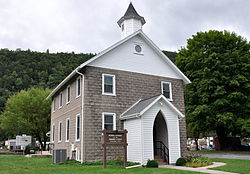
Subsistence farming, the economic mainstay in the early decades, was joined by other enterprises after the arrival of the railroads in the latter part of the 19th century. A post office opened in the village in 1884. The New York Central Railroad built a line through the Pine Creek Gorge, and by the 1890s three logging railroadsthe Trout Run Railroad, the Cammal and Black Forest Railroad, and the Oregon and Texas Railway (named for two nearby mountains) connected to the main line at Campbell. During these boom years, the village had stores, four hotels with saloons, four churches, an International Order of Odd Fellows meeting hall (which sometimes doubled as a church), and a weekly newspaper, the Pine Creek Pioneer. Local industries included a hemlock sawmill and other forest-products companies. [4]

In 1905, after the supply of local timber dwindled, the sawmill and other timber-related industries closed. Residents who remained in Cammal found new sources of income: growing and selling ginseng through about 1940 to Chinese buyers from Philadelphia, providing services to tourists and sportsmen, and working for the railroad or the state forestry or highway departments. [4]

In 2002 the post office closed. However, in the early 21st century, the village still has a few businesses including a saloon and restaurant, a campground, and a community center in the former Odd Fellows hall. [4]

Related Research Articles

<span class="mw-page-title-main">Brown Township, Lycoming County, Pennsylvania</span> Township in Pennsylvania, United States

Brown Township is a township in Lycoming County, Pennsylvania, United States. The population was 92 at the 2020 census. It is part of the Williamsport, Pennsylvania Metropolitan Statistical Area.

<span class="mw-page-title-main">Cummings Township, Lycoming County, Pennsylvania</span> Township in Pennsylvania, United States

Cummings Township is a township in Lycoming County, Pennsylvania, United States. The population was 264 at the 2020 census, down from 273 in 2010. It is part of the Williamsport, Pennsylvania Metropolitan Statistical Area. Cummings Township is home to Little Pine State Park and Upper Pine Bottom State Park.

<span class="mw-page-title-main">Westboro, Wisconsin</span> Town in the United States

Westboro is a town in Taylor County, Wisconsin, United States. The population was 660 at the 2000 census. The census-designated place of Westboro is located in the town. The unincorporated community of Queenstown is also located in the town.

<span class="mw-page-title-main">Larrys Creek</span> Tributary of the West Branch Susquehanna River

Larrys Creek is a 22.9-mile-long (36.9 km) tributary of the West Branch Susquehanna River in Lycoming County in the U.S. state of Pennsylvania. A part of the Chesapeake Bay drainage basin, its watershed drains 89.1 square miles (231 km2) in six townships and a borough. The creek flows south from the dissected Allegheny Plateau to the Ridge-and-valley Appalachians through sandstone, limestone, and shale from the Devonian, Mississippian, and Pennsylvanian periods.

<span class="mw-page-title-main">Pine Creek (Pennsylvania)</span> Creek in Pennsylvania, United States

Pine Creek is a tributary of the West Branch Susquehanna River in Potter, Tioga, Lycoming, and Clinton counties in Pennsylvania. The creek is 87.2 miles (140.3 km) long. Within Tioga County, 23.25 miles (37.42 km) of Pine Creek are designated as a Pennsylvania Scenic River.

<span class="mw-page-title-main">White Deer Hole Creek</span> Tributary of the West Branch Susquehanna River

White Deer Hole Creek is a 20.5-mile (33.0 km) tributary of the West Branch Susquehanna River in Clinton, Lycoming and Union counties in the U.S. state of Pennsylvania. A part of the Chesapeake Bay drainage basin, the White Deer Hole Creek watershed drains parts of ten townships. The creek flows east in a valley of the Ridge-and-valley Appalachians, through sandstone, limestone, and shale from the Ordovician, Silurian, and Devonian periods.

<span class="mw-page-title-main">Anderson Creek (Pennsylvania)</span> Stream in Pennsylvania, USA

Anderson Creek is a 23.6-mile-long (38.0 km) tributary of the West Branch Susquehanna River in Clearfield County, Pennsylvania, in the United States.

<span class="mw-page-title-main">Little Pine State Park</span> State park in Pennsylvania, United States

Little Pine State Park is a Pennsylvania state park on 2,158 acres (873 ha) in Cummings Township, Lycoming County, Pennsylvania in the United States. Little Pine State park is along 4.2 miles (6.8 km) of Little Pine Creek, a tributary of Pine Creek, in the midst of the Tiadaghton State Forest. A dam on the creek has created a lake covering 94 acres (38 ha) for fishing, boating, and swimming. The park is on Pennsylvania Route 4001, 4 miles (6.4 km) northeast of the unincorporated village of Waterville or 8 miles (13 km) southwest of the village of English Center. The nearest borough is Jersey Shore, Pennsylvania, about 15 miles (24 km) south at the mouth of Pine Creek on the West Branch Susquehanna River.

<span class="mw-page-title-main">Upper Pine Bottom State Park</span> State park in Lycoming County, Pennsylvania, United States

Upper Pine Bottom State Park is a 5-acre (2.0 ha) Pennsylvania state park in Lycoming County, Pennsylvania in the United States. The park is in Cummings Township on Pennsylvania Route 44 and is surrounded by the Tiadaghton State Forest. It is on Upper Pine Bottom Run, which gave the park its name and is a tributary of Pine Creek. Upper Pine Bottom State Park is in the Pine Creek Gorge, where the streams have cut through five major rock formations from the Devonian and Carboniferous periods.

<span class="mw-page-title-main">Colton Point State Park</span> State park in Pennsylvania, US

Colton Point State Park is a 368-acre (149 ha) Pennsylvania state park in Tioga County, Pennsylvania, in the United States. It is on the west side of the Pine Creek Gorge, also known as the Grand Canyon of Pennsylvania, which is 800 feet (240 m) deep and nearly 4,000 feet (1,200 m) across at this location. The park extends from the creek in the bottom of the gorge up to the rim and across part of the plateau to the west. Colton Point State Park is known for its views of the Pine Creek Gorge, and offers opportunities for picnicking, hiking, fishing and hunting, whitewater boating, and camping. Colton Point is surrounded by Tioga State Forest and its sister park, Leonard Harrison State Park, on the east rim. The park is on a state forest road in Shippen Township 5 miles (8 km) south of U.S. Route 6.

<span class="mw-page-title-main">Leonard Harrison State Park</span> Park in Pennsylvania, USA

Leonard Harrison State Park is a 585-acre (237 ha) Pennsylvania state park in Tioga County, Pennsylvania, in the United States. It is on the east rim of the Pine Creek Gorge, also known as the Grand Canyon of Pennsylvania, which is 800 feet (240 m) deep and nearly 4,000 feet (1,200 m) across here. It also serves as headquarters for the adjoining Colton Point State Park, its sister park on the west rim of the gorge. Leonard Harrison State Park is known for its views of the Pine Creek Gorge, and offers hiking, fishing and hunting, whitewater boating, and camping. The park is in Shippen and Delmar Townships, 10 miles (16 km) west of Wellsboro at the western terminus of Pennsylvania Route 660.

<span class="mw-page-title-main">Little Fishing Creek</span> Creek in Columbia County, Pennsylvania

Little Fishing Creek is a tributary of Fishing Creek in Sullivan County, Lycoming County, and Columbia County, in Pennsylvania, in the United States. It is approximately 23.5 miles (37.8 km) long and flows through eight townships. The watershed of the creek has an area of 68.1 square miles (176 km2). The creek has six named tributaries, of which the largest are Spruce Run and West Branch Run.

The Susquehanna Boom was a system of cribs and chained logs in the West Branch Susquehanna River, designed to catch and hold floating timber until it could be processed at one of the nearly 60 sawmills along the river between Lycoming and Loyalsock Creeks in Lycoming County, Pennsylvania in the United States. The Susquehanna Boom was originally built under the supervision of James H. Perkins, and operated from 1851 to 1909, when it shut down for lack of timber.

<span class="mw-page-title-main">Pine Creek Rail Trail</span> Rail trail in Pennsylvania, United States

The Pine Creek Rail Trail is the only rail trail in the Appalachian Mountains of north-central Pennsylvania.

<span class="mw-page-title-main">Cedar Run, Pennsylvania</span> Unincorporated community in Pennsylvania, United States

Cedar Run is an unincorporated community in Brown Township, Lycoming County, Pennsylvania, United States. Cedar Run, a stream with the same name as the community, enters Pine Creek at Cedar Run, in the Pine Creek Gorge. The stream is one of a half-dozen tributaries entering from the western side of Pine Creek, along with nearby Slate Run. The Pine Creek Rail Trail passes through Cedar Run. The village is linked to Pennsylvania Route 414 by a spur road crossing a bridge over Pine Creek.

<span class="mw-page-title-main">West Rim Trail</span> Hiking trail in Lycoming County, Pennsylvania, United States

The West Rim Trail is a 30.5 mi (49.1 km) linear hiking trail in Lycoming and Tioga Counties in north central Pennsylvania. The trail mostly follows the edge of Pine Creek Gorge, also known as the Grand Canyon of Pennsylvania, which is up to 1,000 feet (300 m) deep and about 2,000 feet (610 m) wide from rim to rim in the area traversed by the trail. The trail is entirely within Tioga State Forest and is known for its large number of vistas overlooking the gorge, which is a National Natural Landmark and one of the deepest gorges in the eastern United States.

<span class="mw-page-title-main">Pine Creek Gorge</span> A gorge carved by Pine creek in Pennsylvania, United States

Pine Creek Gorge, sometimes called The Grand Canyon of Pennsylvania, is a 47-mile (76 km) gorge carved into the Allegheny Plateau by Pine Creek in north-central Pennsylvania.

<span class="mw-page-title-main">Slate Run, Pennsylvania</span> Unincorporated community in Pennsylvania, United States

Slate Run is an unincorporated community in Brown Township, Lycoming County, in the U.S. state of Pennsylvania. It lies between Blackwell and Waterville along Pennsylvania Route 414. Slate Run, a stream with the same name as the community, enters Pine Creek at Slate Run, in the Pine Creek Gorge. The Pine Creek Rail Trail passes through the village.

<span class="mw-page-title-main">Jersey Mills, Pennsylvania</span> Unincorporated community in Pennsylvania, United States

Jersey Mills is an unincorporated community in McHenry Township, Lycoming County, in the U.S. state of Pennsylvania. It lies along Pine Creek in the Pine Creek Gorge upstream of Waterville along Pennsylvania Route 414. Callahan Run enters Pine Creek at Jersey Mills. The Pine Creek Rail Trail passes through the village.

<span class="mw-page-title-main">Leetonia, Pennsylvania</span> Unincorporated community in Pennsylvania, United States

Leetonia is an unincorporated community in Elk Township, Tioga County, in the U.S. state of Pennsylvania. It lies along Leetonia Road, in the Tioga State Forest between Pennsylvania Route 414 and U.S. Route 6.

References

  1. 1 2 3 "Cammal". Geographic Names Information System . United States Geological Survey, United States Department of the Interior. August 30, 1990. Retrieved September 5, 2012.
  2. United States Geological Survey. "United States Topographic Map". TopoQuest. Retrieved September 5, 2012..
  3. "Pine Creek Rail Trail Map" (PDF). Tioga County Visitors Bureau. Archived from the original (PDF) on March 24, 2012. Retrieved September 5, 2012.
  4. 1 2 3 4 Kagan, David Ira (2008). Pine Creek Villages. Charleston, South Carolina: Arcadia Publishing. pp. 59–76. ISBN   978-0-7385-5663-5.