Willoughby East Sydney, New South Wales | |||||||||||||||
---|---|---|---|---|---|---|---|---|---|---|---|---|---|---|---|
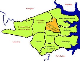
Map of North Willoughby/Willoughby East | |||||||||||||||
Population | 1,822 (2016 census) [1] | ||||||||||||||
Postcode(s) | 2068 | ||||||||||||||
Location | 9 km (6 mi) north of Sydney CBD | ||||||||||||||
LGA(s) | City of Willoughby | ||||||||||||||
State electorate(s) | Willoughby | ||||||||||||||
Federal Division(s) | North Sydney | ||||||||||||||
|
Willoughby East is a suburb on the lower North Shore of Sydney, in the state of New South Wales, Australia. Willoughby East is located 9 kilometres north of the Sydney central business district, in the local government area of the City of Willoughby.
In the 2016 Census, there were 1,822 people in Willoughby East. 72.0% of people were born in Australia and 79.9% of people spoke only English at home. The most common responses for religion were No Religion 30.9%, Catholic 29.6% and Anglican 19.0%. [1]
A bus depot is located in Stan Street.
Gordon is a suburb on the Upper North Shore of Sydney in the state of New South Wales, Australia 14 kilometres (9 mi) north-west of the Sydney Central Business District and is the administrative centre for the local government area of Ku-ring-gai Council. East Gordon is a locality within Gordon and West Gordon within West Pymble.
St Leonards is a suburb on the lower North Shore of Sydney, in the state of New South Wales, Australia. St Leonards is located 5 km north-west of the Sydney central business district and lies across the local government areas of Municipality of Lane Cove, North Sydney Council and the City of Willoughby.
Clontarf is a suburb of northern Sydney, in the state of New South Wales, Australia. Clontarf is located 13 kilometres north-east of the Sydney central business district in the local government area of Northern Beaches Council, in the Northern Beaches region.
Crows Nest is a suburb on the lower North Shore of Sydney, New South Wales, Australia. It is also part of the North Sydney region, 5 kilometres north of the Sydney central business district, in the local government area of North Sydney Council.
Lakemba is a suburb south west of Sydney, in the state of New South Wales, Australia. Lakemba is located 12 kilometres south west of the Sydney central business district, in the local government area of the City of Canterbury-Bankstown.
Lavender Bay is a harbourside suburb on the lower North Shore of Sydney, New South Wales, Australia. Lavender Bay is located 3 kilometres north of the Sydney central business district, in the local government area of North Sydney Council.
Artarmon is a suburb on the lower North Shore of Sydney, in the state of New South Wales, Australia, 9 kilometres north-west of the Sydney central business district, in the local government area of the City of Willoughby.
Castle Cove is a suburb on the lower North Shore of Sydney, in the state of New South Wales, Australia. Castle Cove is located 11 kilometres north of the Sydney central business district, in the local government area of the City of Willoughby. Castle Cove is situated on the western side of Middle Harbour.
Willoughby is a suburb located on the lower North Shore of Sydney, in the state of New South Wales, Australia 8 kilometres north of the Sydney central business district, in the local government area of the City of Willoughby.
Roseville is a suburb on the Upper North Shore of Sydney in the state of New South Wales, Australia 12 kilometres (7.5 mi) north-west of the Sydney central business district, in the local government areas of Ku-ring-gai and Willoughby. Roseville Chase is a separate suburb to the east.
Queenscliff is a suburb of northern Sydney, in the state of New South Wales, Australia. Queenscliff is located 16 kilometres north-east of the Sydney central business district, in the local government area of Northern Beaches Council and is part of the Northern Beaches region.
Middle Cove is a suburb on the Lower North Shore of Sydney, in the state of New South Wales, Australia 9 kilometres north of the Sydney central business district, in the local government area of the City of Willoughby.
Padstow Heights, a suburb of local government area City of Canterbury-Bankstown, located 23 kilometres south-west of the Sydney central business district, in the state of New South Wales, Australia. It is a part of the South-western Sydney region. Padstow is a separate suburb to the north and One Tree Point is a locality within Padstow Heights.
Chatswood West is a suburb on the Lower North Shore of Sydney, in the state of New South Wales, Australia. Chatswood West is located 11 kilometres north-west of the Sydney central business district, in the local government areas of the City of Willoughby and City of Ryde. Chatswood is a separate suburb. The area of Chatswood located west of the Pacific Highway is informally known as West Chatswood, which should not be confused with the separate suburb of Chatswood West, nor should it be confused with the West Chatswood Post Office on Railway Street in the Suburb of Chatswood. Chatswood West shares the same postcode as Chatswood which is 2067.
East Lindfield is a suburb on the Upper North Shore of Sydney in the state of New South Wales, Australia. East Lindfield is located 13 kilometres north-west of the Sydney Central Business District in the local government area of Ku-ring-gai Council. Lindfield is a separate suburb to the west sharing the postcode of 2070.
East Killara is a suburb on the Upper North Shore of Sydney in the state of New South Wales, Australia. East Killara is located 15 kilometres north of the Sydney Central Business District in the local government area of Ku-ring-gai Council. Killara is a separate suburb to the south-west, which shares the postcode of 2071.
Henley is a suburb on the lower North Shore of Sydney, in the state of New South Wales, Australia. Henley is located 9 kilometres west of the Sydney central business district, in the local government area of the Municipality of Hunter's Hill. Henley sits on the northern side of the Parramatta River.
Lane Cove North is a suburb on the Lower North Shore of Sydney of Sydney, in the state of New South Wales, Australia. Lane Cove North is located 11 kilometres north-west of the Sydney central business district, in the local government areas of the Municipality of Lane Cove and the City of Willoughby. Lane Cove and Lane Cove West are separate suburbs.
North Willoughby is a suburb on the Lower North Shore of Sydney, in the state of New South Wales, Australia 9 kilometres north of the Sydney central business district, in the local government area of the City of Willoughby. Willoughby and Willoughby East are separate suburbs.
Huntleys Cove is a suburb 0n the Lower North Shore of Sydney, in the state of New South Wales, Australia. Huntleys Cove is located 9 kilometres north-west of the Sydney central business district, in the local government area of the Municipality of Hunter's Hill. Huntleys Cove sits on the peninsula between Tarban Creek and the Parramatta River.
Coordinates: 33°47′56″S151°12′22″E / 33.799°S 151.206°E
This article related to the geography of Sydney is a stub. You can help Wikipedia by expanding it. |