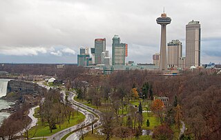
Niagara Falls is a city in Ontario, Canada. It is on the western bank of the Niagara River in the Golden Horseshoe region of Southern Ontario, with a population of 94,415 at the 2021 census. It is part of the St. Catharines - Niagara Census Metropolitan Area (CMA). Incorporated on 12 June 1903, the city is across the river from Niagara Falls, New York. The Niagara River flows over Niagara Falls at this location, creating a natural spectacle which attracts millions of tourists each year.

Niagara-on-the-Lake is a town in Ontario, Canada. It is located on the Niagara Peninsula at the point where the Niagara River meets Lake Ontario, across the river from New York, United States. Niagara-on-the-Lake is in the Niagara Region of Ontario and is the only town in Canada that has a lord mayor. It had a population of 19,088 as of the 2021 Canadian census.

Lewiston is a village in Niagara County, New York, United States. The population was 2,701 at the 2010 census. The village is named after Morgan Lewis, an early 19th-century governor of New York. It is part of the Buffalo–Niagara Falls Metropolitan Statistical Area.
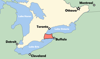
The Niagara Peninsula is an area of land lying between the southwestern shore of Lake Ontario and the northeastern shore of Lake Erie, in Ontario, Canada. Technically an isthmus rather than a peninsula, it stretches from the Niagara River in the east to Hamilton, Ontario, in the west. The peninsula is located in the Golden Horseshoe region of Southern Ontario, and has a population of roughly 1,000,000 residents. The region directly across the Niagara River and Lake Erie in New York State is known as the Niagara Frontier.

Queenston is a compact rural community and unincorporated place 5 kilometres (3.1 mi) north of Niagara Falls in the Town of Niagara-on-the-Lake, Ontario, Canada. It is bordered by Highway 405 to the south and the Niagara River to the east; its location at the eponymous Queenston Heights on the Niagara Escarpment led to the establishment of the Queenston Quarry in the area. Across the river and the Canada–US border is the village of Lewiston, New York. The Lewiston-Queenston Bridge links the two communities. This village is at the point where the Niagara River began eroding the Niagara Escarpment. During the ensuing 12,000 years the Falls cut an 11 kilometres (6.8 mi) long gorge in the Escarpment southward to its present-day position.
Chippawa is a community located within the city of Niagara Falls, Ontario.

Welland County is a historic county in the Canadian province of Ontario.

The Welland River is a river in the Golden Horseshoe that passes through the Southern Ontario cities of Welland and Niagara Falls. It flows from its source, a Drainage Basin just south of Hamilton, Ontario to meet the Niagara River.
The Battle of Cook's Mills was the last engagement between U.S. and British armies in the Niagara, and the penultimate engagement on Canadian soil during the War of 1812. After about a half-hour, American forces out-maneuvered the British column and destroyed all grain and flour.
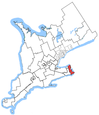
Niagara Falls is a federal electoral district in Ontario, Canada, that has been represented in the House of Commons of Canada since 1953.

Niagara Centre is a federal electoral district in the Niagara Region of Ontario that has been represented in the House of Commons of Canada from 1867 to 1988 and since 1997.
The Niagara Parkway, formerly known as Niagara Boulevard and historically as the Niagara Road, is a scenic road in the province of Ontario that travels on the Canadian side of the Niagara River from the town of Fort Erie to Niagara-on-the-Lake. The portion north of Table Rock in the city of Niagara Falls is designated as an Ontario Scenic Highway. Niagara Boulevard originally referred only to the section from Fort Erie to Chippawa.

Sir Adam Beck Hydroelectric Generating Stations are two hydroelectric generating stations in Niagara Falls, Ontario, Canada. Sir Adam Beck Generating Station I, Sir Adam Beck Generating Station II and the Sir Adam Beck Pump Generating Station are all owned by Ontario Power Generation. Following the development of several smaller generating stations around Niagara Falls in the late 19th and early 20th centuries, the Province of Ontario authorized the construction of the first major publicly owned generating station in the province. At the time it was built, it was the largest hydroelectric generating station in the world.
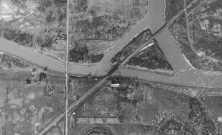
The Montrose Swing Bridge is located on the Welland River at the junction with the Queenston Power Canal in the southeast portion of the City of Niagara Falls, Ontario, Canada. It was built ca. 1910 to carry the Canada Southern Railway over the river. It is a two-track bridge, although only one track remains in use today. It crosses the river at roughly a 45-degree angle.

Stamford Township is a former incorporated and now geographic township in Upper Canada, later Ontario, on the Niagara Peninsula. It was originally designated Township #2 in the Home District of the Quebec Colony in Canada. Following the creation of Upper Canada in 1791, Township #2 was renamed Stamford and placed within the newly created County of Lincoln. When Lincoln county was divided into Lincoln (north) and Welland (south) counties in 1851, Township #2 was placed in Welland County.

Griffin House is a house built in 1827 by Englishmen in Ancaster. It was purchased, along with 50 acres of farmland, by Enerals Griffin and his wife Priscilla in 1834. The Griffins were enslaved in their early lives, but self-liberated by escaping to Canada in the early 1800s. The Griffins were some of the first Black Settlers in the area, and the site remains an important part of Black history in Canada. . It offers Underground Railroad tours and history-related programs.

Queen Victoria Park is the main parkland located in Niagara Falls, Ontario, Canada opposite the American and Canadian Horseshoe Falls. Established by the Niagara Falls Park Act in 1885 and opened in 1888, the park is operated by the Niagara Parks Commission and is considered the centerpiece of the Niagara Falls recreational tourist area.
Das Haus und Der Stahl, also known as Das Haus Museum, are a small campus of buildings containing artifacts that represent the early years of German Lutheran settlers in Western New York originating from Prussia in northern Germany. The buildings were restored and maintained by the Historical Society of North German Settlements in Western New York as a museum of area German heritage. The museum is located in Niagara Falls, New York on the site where Das Haus was originally built. Potter Charles August Mehwaldt created his fired-clay decorative and functional items across the street from the campus.
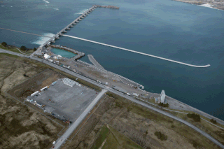
The International Control Dam, also known as the International Control Structure, operated by Ontario Power Generation, is a weir that controls the water diversions from the Niagara River and dispatches the water between the New York Power Authority and Ontario Power Generation in accordance with the terms of the 1950 Niagara Treaty. It was completed in 1954.

The Niagara Falls History Museum is a local history museum in the city of Niagara Falls, Ontario, Canada.
